Monday, April 2, 2012

Croggan Pier

I've been published! Well not quite but I do have my name in print in a book that's just been published, namely, Alistair Deayton's West Highland Piers

Top - MacBrayne's cruise steamer King George V (1936-74) at Fort William; bottom - the Corran Ferry
My contribution was two from my postcard collection, namely, the north terminus of Kylesku ferry (page 85):-

... and the north terminus of the old Bonawe Ferry across Loch Etive (page 92):-


I like piers. They're places where you can watch boats and sometimes even get on one which is always a good thing.  If not, then you're often surrounded by water on three sides and can pretend you're on a boat. You can also go fishing. When I was young, I remember being invited to go "beach fishing" and thinking, "What's that all about - surely you can only go fishing from a pier?" As a child (late 60s, early 70s), we were more likely to say "Can we go to the pier?" than to the beach.

Armadale on Skye - a pier which ticks a lot of boxes
In the introduction to his book, Alistair makes the point that piers used to be a vital part of the transport infrastructure because, before the advent of the internal combustion engine and decent roads in the first few decades of the 20th century, many remote areas, even on the mainland, depended on delivery of goods by sea. This was summed up by an article I once read in the online archive of "the Scotsman" about transport problems to Gairloch in Wester Ross in (I think) the 1930s. The locals were campaigning, not for improvements to the road from Inverness, as you'd expect nowadays, but for improvements to the pier so that cargo steamers would not be prevented so often from calling due to low tide.

MacBrayne's cargo steamer SS Claymore (1881-1931) at Gairloch Pier
But unless they happened to coincide with a railhead, a fishing port (as at Gairloch) or a modern car ferry terminal (e.g. Uig on Skye), the majority of these piers were abandoned in the mid 20th century as the transport of goods was moved to the roads. Only a few of the rest have survived, often on islands now served by car ferries operating to slipways (e.g. Jura, Lismore & Gigha) where the old style pier has been retained in case of a load which can't come on the back of a vehicle. This load of electricity poles to replace ones felled in the December storms of 2011 was touch and go for getting to Lismore on the back of truck via a slipway:-


Anyway, one of my favourite abandoned "local piers" (although it's not in Alistair's book because I'm guessing there's a sequel to come called "Western Isles Piers") is the one at Croggan on the south shore of Loch Spelve in Mull.


 In such a very remote location, the pier seems incongruously imposing. There are just a handful of crofts at Croggan (now, of course, mostly holiday houses) although it was no doubt designed also to serve the needs of the village of Lochbuie a mile or two to the west which is too exposed to the prevailing south westerly winds to allow reliably regular calls by steamers.

Photo credit ceeyefaitch
 
Croggan - picture credit Graham Maxwell
I don't know anything about the history of the pier at Croggan, when or in what circumstances it was built. But with both having a little stone building at the pier head and concrete supports for the bridge out to the berthing head, Croggan looks very similar to the abandoned pier at Black Mill Bay on the island of Luing just across the Firth of Lorne from Mull. I'd guess they were both built around the same time as part of an early 20th century programme of providing remote communities in this part of Argyll with piers.

 
Black Mill Bay, Luing

The ship in the postcard view of Black Mill Bay pier above is MacBrayne's cargo steamer, SS Handa. She was sold out the fleet in 1917 which I think helps date Croggan Pier to before that year.

EDIT - also just noticed that the pier is marked on the 1897 edition of the Ordnance 6 inch map.


Anyway, this is all by way of a very long introduction to a series of photos of Croggan Pier in use which I was fasconated to see on the Ships of Calmac forum. They were taken by forum member Craig McDowall's grandfather who grew up in Croggan (his grandmother from Lochbuie although they all now live in the north of Mull) and with Craig's permission I reproduce them here and let them speak for themselves:-


In the first three pictures above, the ship is MacBrayne's MV Lochshiel. Built in 1929, she carried cargo from Glasgow, round the Mull of Kintyre (significant because previous ships on the route went through the Crinan Canal) to points on the Sound of Jura, Firth of Lorne, Loch Linnhe, Sound of Mull and as far north as Loch Sunart (including Glencripesdale). The Lochshiel was sold for scrap in 1952 when she was replaced by a later, post WW2 generation of cargo boats. It's one of these at the pier in the fourth photo above, I think the Loch Carron (1951).


I don't know exactly when Croggan Pier closed for business, but in Duckworth & Langmuir's "West Highland Steamers", I read that, from July 1953, "further road transport and cargo trans-shipment  was introduced so that Glasgow goods for Luing, Lismore and Croggan were conveyed via Oban." I don't know how that would have worked in practice, though - were goods for Croggan off-loaded at Oban, transferred there to the Mull mail steamer, then off-loaded again at Salen (the first pier on Mull up the Sound of Mull before Craignure Pier was built in 1963) and eventually taken by lorry to Croggan and Lochbuie? If so, I'm not sure how that fits with the fact that D&L tell us in the next sentence that goods for Bunessan and Fionnphort, further west on Mull, were to be conveyed by road from the cargo steamer at Tobermory. Anyway, I'm guessing the changes in 1953 spelt the end for Croggan Pier (and Black Mill Bay on Luing). Cargo services to the Western Isles finally ended in 1976 with all the islands by then being linked by ro-ro ferries.

Picture credit tobers

Wednesday, March 28, 2012

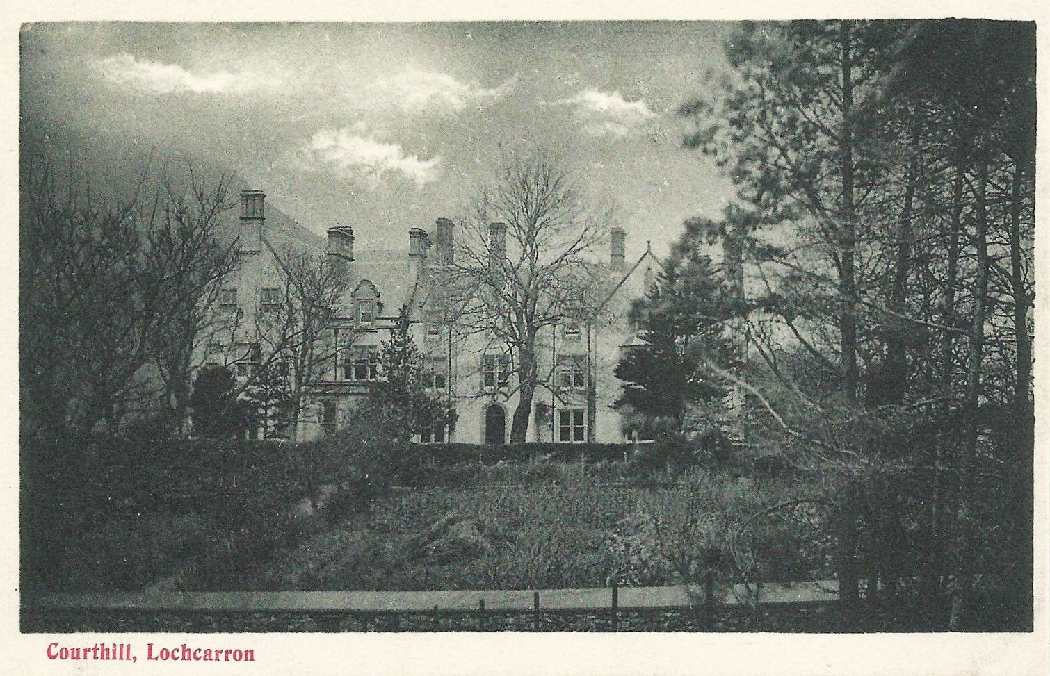
Courthill

Courthill is a derelict Victorian mansion house at Kishorn in Wester Ross. I went for quick look round the outside of it on a very wet (and unsuitable for photography) day in December 2011.


I remember Courthill from the 1960s when we used to go on holiday to a cottage in nearby Achintraid when I was a child. I remember my parents telling me the roof was deliberately taken off after the War because the lead was more valuable than the house. That sort of thing that gets a 6 year old thinking - what's so good about lead that it's more expensive than a house? Especially a very big one like Courthill - are you sure it wasn't roofed with gold?


Below is the only picture I've ever seen of Courthill when it was still in use. It was taken in July 1931 and comes from the collection of Robert M Adam held by St Andrews University Photo Archive. [See Update at the end of this post for two more pictures.]


I had to look long and hard at that photograph to reassure myself it was indeed Courthill. But it is - what's in the centre of my photo at the top is off to the left behind the trees but the right hand bit in my photo is what's on the left of the 1931 pic.

As to the history of the house, around the turn of the 18th and 19th centuries, Courthill was the smallest of the three estates which comprised the parish of Lochcarron. It belonged to Major Alexander Macdonald: a great grandson of Sir James Macdonald, 9th chief of the Macdonalds of Sleat, and married to a niece (by another account, a great grand-daughter) of Flora Macdonald, he was also tacksman (tenant) of Monkstadt in Trotternish on Skye where he lived.

An interesting snippet is that this well connected member of Clan Donald held Courthill as feudal vassal of the Earl of Seaforth, the chief of the MacKenzies - in earlier centuries, that might have caused a conflict of clan loyalties but was an irrelevance by the late 18th century.

Major Alexander Macdonald of Courthill & Monkstadt
An overtly English name like "Courthill" in the overwhelmingly Gaelic world of 19th century Wester Ross usually betrays an interesting story. I've not been able to find any explanation except that the name was in existence as early as 1807 when it's marked on Aaron Arrowsmith's map of that year.-

It's interesting to note that it's marked as "Court Hill or Laggandown" on the Arrowsmith map (above). Laggandown also appears on the Roy Maps of the 1740s-50s:-


So Laggandown - which I think is Gaelic for "brown hollow" - was the original name of a place which became known as Courthill. I'd guess an 18th century laird who'd made some money abroad settled there but decided its Gaelic name was too uncouth so he changed it to the name of his English wife's parents' house - or something like that. It's the reverse equivalent today of people buying a house in Wester Ross called "Sea View" and deciding that's too pedestrian and renaming it something more couthy like "Sealladh na Mara" (which I believe to be the Gaelic for "view of the sea").

Who changed the name, I can't discover but we read in a footnote to page 276 of Alexander Mackenzie's magisterial "History of the Macdonalds and Lords of the Isles" (1881) that Major Macdonald of Courthill's eldest son, another Alexander, "was never married. He became insane when a young man by an operation performed on his ears for deafness, and lived principally with his brother Hugh [at Monkstadt], and was quite harmless." Whether that tragic circumstance had anything to do with it, I don't know, but the New Statistical Account for the Parish of Lochcarron compiled in 1836 recorded that there were now only two landowners in the parish which indicates that the Macdonalds had sold Courthill to their neighbours, the MacKenzies of Applecross. (The other landowner was Matheson of Attadale.)

In 1854, Thomas MacKenzie, 9th laird of Applecross, sold the whole of his estates, including Courthill, to the splendidly named Francis Godolphin D'Arcy D'Arcy Osborne, 7th Duke of Leeds.

Arsy-D'Arcy D'Arcy to his friends
The sale was part of a common pattern in the mid 19th century in which native families who had owned their lands for generations sold out to Victorian nouveaux riches. But the Duke of Leeds didn't enjoy his new Scottish estate for long. In 1859, only five years after he had bought it, he died and Applecross passed to his nephew, the equally splendidly named Sackville George Lane Fox, Lord Conyers. Two years later, in 1861, Conyers sold the Applecross estate in lots. The central portion - which included Courthill and became known as Lochcarron Estate extending to 32,450 acres - was bought by Sir John Stuart.  

Approximate boundaries of Lochcarron Estate bought by Sir John Stuart in 1861
Stuart was the son of a family from Ballachulish in Argyll who became a barrister in London, then an MP before becoming a senior judge in the English courts. He retired in 1871 and died in 1876. His grave in the old cemetry next to Courthill House can still be seen.

Sir John Stuart of Lochcarron's grave - photo credit Roddie Macpherson
Sir John was succeeded by his son Dugald Stuart but in 1882, only six years after he came in to his inheritance, he sold Lochcarron Estate to Charles James Murray, the MP for Hastings (as in "Battle of ...". He later moved to be MP for Coventry 1895-1906.)

As to the history of Courthill House (as opposed to its surrounding estate), my main source of information is the scottisharchitects.org website. This merely records that "alterations and repairs" were carried out in 1856 by architect Alexander Ross. I suspect that understates what happened in 1856. I'd guess that hitherto Courthill was an unpretentious Georgian farm house and what Ross did was convert it into a Victorian mansion house. I suspect the Duke of Leeds, having just bought the whole Applecross Estate in 1854, fixed on Courthill as his seat and commissioned Ross to transform it into something befitting his ducal station (perhaps as a conscious departure from the MacKenzies' seat at Applecross itself)

The architects.org website records further additions in 1883 after the Murrays acquired the house and more in 1901 including the addition of a conservatory. Extensions to Courthill can be seen between the 1875 and 1902 editions of the Ordnance Survey Map below. Generally, it seems to have expanded east and north (that's to the right and behind in the photos above):-


Provost of Inverness 1889-95, the architect Alexander Ross, was responsible for a number of Victorian buildings in this part of Scotland including Gairloch Hotel and Duncraig Castle. There's more about him, with a photo, here.

In 1885, Charles Murray's daughter, Elspeth, died aged just 4. In 1900, tragedy afflicted the family again when his eldest son, Lieutenant Alastair Murray of the Grenadier Guards, was killed in action during the Boer War aged 22. Amongst the 1901 additions to Courthill was a chapel which included stained glass windows in memory of Elspeth and Alastair. More information about the chapel with pictures on Undiscovered Scotland.

Picture credit James Yardley

According to the Undiscovered Scotland website linked to above, the Murrays lost part of their fortune during World War I and came to live at Courthill full time as a result. This sort of suggests they were "slumming it in the holiday home" but I don't know what other estates or houses they had. Maybe it was just a case of having to sell the Edinburgh and/or London townhouses. 

C J Murray died in 1929 and his wife four years later. Despite their wealth and privilege, they'd had their fair share of tragedy and worry and apparently the death of Mrs Murray in 1933 was when Courthill was abandoned. [See Update at the end] The Murrays' surviving son, Charles, junior, had meantime [See Update] built himself another, no doubt smaller and more manageable house elsewhere on the estate. I don't know, but I'm guessing that house is Couldoran, a few miles north of Courthill on the road to Shieldaig.

Couldoran with the hills of Applecross behind

Charles Murray, junior, died in 1945 and that was the catalyst for the sale of Lochcarron Estate. It was sold in lots in 1946 and the purchaser of the lot with Courthill House on it, having no use for the house and finding it a liability, took the roof off and sold the lead to avoid having to pay rates on it. I don't know who the ruin belongs to now but the Murray family retained the chapel in 1946 and eventually gifted it to the Scottish Episcopal Church in 1979. It's still in business as a church (with wheelchair access as well) - further details here.

 
 Above is the partially blocked main gate of Courthill. The three stars in the crest are a feature (yellow on blue) in the arms of both the Dukes of Atholl and the Earls of Dunmore, both peerages held by Murrays. The Courthill family are descended from the Dunmores except that the stars in the Atholl and Dunmore arms are both two on top and one underneath contrary to the pattern at the gate of Courthill. I wonder if C J Murray unofficially adopted an ancient Murray motif with a minor adaptation so as not tousurp the arms of his more exalted cousins? Below the crest on the gate is an inscription in Gaelic (I think) but I don't know what it means.

Courthill seen from Google Earth
As I've typed this story about Courthill, I couldn't help thinking about Downton Abbey. The TV series portrays an image of these country houses as being somehow timeless, permanent and enduring. But so often when you dig in to the history, you discover just how ephemeral many of them actually were. Courthill has now stood empty and ruinous for almost as long as it was in use - just 75 years or so from the 1850s to the 1930s.

Picture credit Joe Dunckley
UPDATE 19 February 2018 - thanks very much to all those who've taken the trouble to comment on this post. From these we can deduce that Courthill was abandoned in 1943 rather than 1933. And according to Couldoran Estate's website, that house was built in 1929. Below are two further postcards of Courthill while still complete I've found since I wrote this post:-


Wednesday, February 22, 2012

Map Update

The National Library of Scotland has recently released a further batch of old Ordnance Survey maps available to view (free) online at their website.

This includes later editions of the six and twenty five inch maps (mostly early 20th century to add to the mostly 1870s-80s editions already there) and, for the first time, 1:25,000 from the 1950s and 60s and the 7th series of the one inch map from the 1950s. Coverage of the twenty five inch and 1:25k isn't complete over the whole of Scotland yet (I assume it's a work in progress scanning them all) but there's more than enough to feast the eyes on meantime.

The NLS website is also very user-friendly. Basically, there's two options for navigating the maps. The first is the Sheet Viewer:-

  
That shows the coverage of the 1890-1960 25 inch maps in purple but you select the map series you want on the left, zoom in, click on the area you are interested in and it will show you the sheets for that location. Click on that and the sheet in question opens in a new window. Simple!

The second option is the Mosaic Viewer which lays the maps seamlessly over the Google Map or satellite image.


That shows the coverage of the 1950s 1:25k maps. I find the Mosaic Viewer tends to load rather slowly when panning and zooming but it has two huge plus points. Firstly, the maps are seamless. You can see the joins, obviously, but it's a vast improvement because what OS map lover hasn't been frustrated by his area of interest being on the horizontal fold or, worse, sliced right down the middle by two adjacent sheets.

South Harris in one piece at last!
Not all maps are visible on the Mosaic Viewer, notably the 6 and 25 inch. But equally, some are only available on the Mosaic including the 1:25k and also the lovely Bartholomew half inch maps (although there's a separate list of them here).

The second advantage of the Mosaic viewer is you can fade the map out with a slider to reveal the underlying Google satellite image or map. This is fantastic for comparing then and now:-

Glascarnoch Dam reveals itself behind the Aultguish Inn
What blows me away about this is how accurate the OS got it back in the 1870s. Now that you can compare their laboriously surveyed boundaries with the empirical evidence of the aerial view, you find they were absolutely spot on.

When you consider Google Streetview allows you to go and have a look at it "on the ground" as well, I can spend HOURS with this - it's definitely NSFW!

Aultguish

Monday, January 16, 2012

Stromeferry (again)

A couple of years ago, I wrote a series of articles about the Wester Ross village of Stromeferry - how it had enjoyed a brief heyday from 1875 as the only railhead on the west coast of Scotland outside the Firth of Clyde until it was eclipsed in 1897 by the railway being extended to Kyle of Lochalsh; how it had come back to life somewhat in the early 20th century when the motor era gave new trade to the ferry across Loch Carron; and how Stromeferry was plunged back into obscurity for a second time in 1970 when the ferry was replaced by a road round the loch which by-passed the village itself and left it noted only for its famous road sign (which most people drive past).

Photo credit Micheal Macintyre
I find myself revisiting this subject to report that - incredibly! - the sign has been rendered temporarily inaccurate and the Strome Ferry has re-opened! This is because the road round the south shore of Loch Carron which replaced the ferry in 1970 (the A890) has been closed by a rockfall.


This happens periodically and usually the road can be re-opened in a day or two but this time it's been closed virtually continuously since 22 December 2011. Highland Council have been advised that the danger of further landslides is so great that the road will have to remain closed until some some radical surgery to the rockface is undertaken which could take weeks if not months.

Road closed at point "X"
What gives this particular urgency is the fact that children from the village of Lochcarron on the north side of the loch go to school at Plockton on the south side. Absent the road round Loch Carron, the only alternative is a 140 mile detour via Inverness. Hence why the Council have been forced to re-open the Strome Ferry across the loch with effect from Monday 16 January 2012.

Two vessels are being used - the first is the Sula Mhor, a boat which normally operates summer seal and dolphin spotting cruises out of Plockton (see Calum's Plockton Seal Trips):-

Picture credit trawlerphotos.co.uk
The Sula Mhor will carry passengers on just a couple of runs morning and afternoon on a schedule designed round the school run - full timetable downloadable here.

The other vessel will be the car ferry Glenachulish. She is the six car turntable ferry which normally operates the summer only Kylerhea ferry to Skye and is laid up in winter at the former oil rig construction site in nearby Loch Kishorn. She was originally built for the Ballachulish Ferry in 1969 but superseded by the Ballachulish Bridge in 1975. The Glenachulish will shuttle across the Strome Ferry between 9am and 5pm. See this link for the Council's arrangements for marshalling vehicles at the Golf Course on the north side and "at the cattle grid" on the south side. I must say, I can't quite visualise how this is going to work - and I'm not sure the Council can either. In the old days, you just drove up and joined the queue. There was no "marshalling" involved! I bet calling 40 year old infrastructure back in to use at short notice is causing a few Health & Safety grey hairs!

 Below is the only photo or Youtube I've been able to discover online so far. I believe it shows the Glenachulish conducting a berthing trial at North Strome last week rather than on actual service this week:-


The only remaining turntable ferry, the Glenachulish is of exactly the same configuration as the last ferries to operate at Strome Ferry in 1970:-


That is the Pride of Strome whose remains are still visible beached a short distance up the loch:-

So, to me, seeing a turntable ferry draw up to the slipway at Strome again is like travelling back in time. If anyone's got any photos or videos of the ferry in action, then do leave a comment linking to them.

EDIT - a nice series of the Glenachulish's first day in operation by Donald Morrison here

Picture credit - Donald Morrison

Friday, November 4, 2011

Glencripesdale Estate - Part 4

I see from the estate agent's website that Glencripesdale is now under offer so I need to wrap this story up.

In Part 3, we'd reached early 2005 when, six weeks before the opening of a public local enquiry into his plans, estate owner Hugh Whittle threw in the towel on his second attempt to get planning permission for a lodge and worker's house and an upgrade to the pier formed by an old barge beached on the shore to enable extraction of timber by sea rather than by road.

Glencripesdale House bottom and the barge pier top
The next development was that, in April 2005, the planners granted a five year extension to the existing time limited planning permission for the barge pier (as distinct from the previous applications to upgrade it which had been refused) to permit extraction of a further 50-80,000 tonnes of timber. This was granted despite the efforts of serial objectors Mr Colville (owner of holiday accommodation locally who believed there was no need for any further holiday accommodation and fretted that the pier's retention would "permanently damage the amenity, scenic value and ecology of Loch Sunart") and Mr Besterman (owner of Glencripesdale House whose lawyers had drafted a lawyerishly pettifogging objection to the effect the application was flawed because it requested extension of the life of a jetty when what was being discussed was a barge.)

But Mr Whittle didn't attempt to lay siege to the planning citadel in earnest again until August 2008 when he lodged four new applications for: (1) extension and permanent retention of the barge pier; (2) estate worker's house; (3) agricultural/forestry store; and (4) "estate manager's house" - i.e. lodge - on the site of the demolished 1870s mansion house.


There's nothing in the public domain to explain the delay of nearly two years before these applications came before the Lochaber Planning Committee in June 2010 but what we do have this time is the planning officer's report to the committee which you can download here (scroll down to "Planning Applications to be Determined"). What's noticeable from this is the statement that the only reason the officials were bringing the applications before the councillors of the committee (as opposed to deciding them themselves under delegated powers) was "minor departure from development plan and number of representations". This was despite - or perhaps because of - the number of reports Mr Whittle lodged in support of his applications including:-

*Supporting Planning Statement by Brindley Consulting dated June 2008.
*Estate Plan dated 4 July 2008.
*Building Design Statement by Iain Dawson Architecture dated 12.10.07.
*Landscape Strategy.

*Ecological Survey Report by Mackenzie Bradshaw Environmental Consulting date June 2008.
*Drainage and Ground Assessment by JIG Environment Ltd dated May 2007.
*Sea Access Background Information, including Condition Survey (Aug.06),
*Options and Recommendations, and Method Statement by Arch Henderson
*Consulting Engineers and Mackenzie Bradshaw Environmental Consulting.
*Operational Needs Assessment by Smiths Gore dated December 2009.


How eye-wateringly expensive does that lot sound?


 There was also media coverage in the Scotsman and Press and Journal focussing on Hugh Whittle's claim to be the only laird in Scotland without a house on his estate - which is a little bit disingenuous considering he's got another estate, Glenfeochan just south of Oban, which has a very nice house on it:-

 
What was no different this time round, though, were the massed ranks of NIMBYs - there were 57 objections. The planning report doesn't tell us who they were although it did record a statement on behalf of Mr Whittle that "a large number of objectors do not live in the neighbouring communities and/or have responded to a factually incorrect flyer circulated out of Glencripesdale House". They included such perennial nanny state, bottom of barrel scraping chestnuts as:-

*Concerns over servicing due to remote location.
*Impacts on the remote wilderness quality of the area through visual impact of buildings and increased activity associated with agricultural and tourism uses.
*Precedent these proposals would set for further development, both locally and nationally.
*Impacts on local biodiversity.
*Development does not offer significant employment to local people.
*Concerns that applications are motivated by personal financial gain.
*Area is inhospitable for a large part of the year and strategically unsuitable for family life.
*Concerns raised over animal welfare due as veterinary visits would be commercially prohibitive.
*Increased light pollution.
*Increased noise pollution.
*Increased traffic and inadequate access.
*Impact of sewerage disposal on the local environment.
*Pollution from dust.
*Inappropriate size of properties proposed.
*Impact on landscape quality.
*Impact on protected species.
*Estate could be managed by someone living on the northern side of the loch, travelling to work by boat.


That last point is particularly egregious considering an objection to previous applications was the health and safety implications of living alone on the otherwise deserted south shore of Loch Sunart - what are the H&S implications of travelling to work every day across the loch in a boat? The only thing missing is the statutory bat colony (although maybe that's implicit in "impact on protected species").

Estate worker's house - nice work if you can get it
But despite (or - again - perhaps because of) all these objections, the final battle with the planners was less of a bang than a whimper: this time, there was no site visit or public hearing and the minutes of the planning committee record simply that it accepted the planning officer's recommendation that all four applications be granted subject to the conditions that they may not be sold separately from the estate and that the estate itself may not in future ever be subdivided. Both houses must be occupied only by the owner of, or a person employed by, Glencripesdale Estate (no allowance for letting to stalking parties which the committee had been prepared to concede in 2004). This time round, Mr Whittle was obviously not of a mood to argue with these conditions which had proved such a stumbling block previously.

The "estate manager's house"
So what's to be made of all this? Is Hugh Whittle a shrewd operator who achieved his goal of an upmarket country sports retreat amongst virgin wilderness by deliberately playing the long game with Highland Council and running rings round them with talk of "estate manager's houses"? (Tiresome conditions can always be lifted at a later stage.) Or is he someone who's suffered from the very worst of everything that's wrong with big government and nanny statism - why shouldn't anyone be allowed to build what they want on their own land?

Glencripesdale Estate sale plan
I suppose you have to rationalise it by saying that, if you accept there has to be a planning system at all, then that involves some people being refused permission. If there were no planning system (or there were but it was too easy to get permission), then presumably the south shore of Loch Sunart would now be lined with houses to its general detriment. But would that be so bad and/or would the problem be as bad in practice as might be feared? There were no planning laws in the 18th century when Glencripesdale Farmhouse was built and it's a listed building. And I bet the Newton Brothers' Victorian mansion would be as well if it were still standing. But having said that, I know from experience here in the Azores what happens when planning laws are lax and the fees for "building permits" form a significant part of local authorities' budgets:-

That's a development by the shore at Faja Grande on the island of Flores where I live. It was begun at the height of the southern European property bubble without a thought being given to whether anyone would buy the apartments. The universal reaction is "How on EARTH could they have given permission to build THAT in such a beautiful environment?". It may not appear from a glance at the photo, but the apartments are not finished and work stopped about a year ago. Now the bubble has burst, they never will be finished, no-one will ever buy them, and they will form a blot on the landscape for years to come.

I used to argue with locals here who were averse to development, saying they should count themselves lucky because in Scotland it's practically impossible to get planning permission. I've since modified my view a bit but there's balance to be struck. I'm not sure it's being struck in the right place, whether on the shores of Loch Sunart or of Flores.

Friday, October 21, 2011

Glencripesdale Estate - Part 3

Before carrying on from Part 2, I've discovered another historical nugget in the meantime. Until 1952, MacBraynes ran a cargo steamer to Loch Sunart every 10 days from Glasgow. Called the MV Lochshiel, she called at Glencripesdale amongst a number of other places along the way:-

Scan from "MacBrayne Steamers" by Alistair Deayton which you can buy here
With no pier at Glencripesdale, it was a ferry call involving the Lochshiel lying off and being tendered to by the estate launch. It's an interesting reflection on how small remote settlements used to be served by sea and that the mere fact there wasn't a road to your front door wasn't an insuperable barrier. 

Anyway, back in the 21st century, we'd got to the point where, in 2003, the new owner of Glencripesdale, Hugh Whittle, had developed a plan to restore the estate from the Forestry Commission's 1950s mono-culture forestry plantation back to farming cattle among native broadleaves rather as it had been operated by the Newton family in its Victorian and Edwardian hey-day. Changes to forestry and farming management don't require planning permission (p/p) but Mr Whittle also envisaged a new lodge, an estate worker's house and improvements to the "beached barge" pier, all of which do require p/p.


The three planning applications were lodged with Highland Council in spring 2003 but first, a general word about planning. Applications for p/p are decided by reference to the prescriptions of local plans. A feature of the Lochaber Local Plan 1999, the ruling document for the Sunart area in 2003, was "a strong presumption against" new houses in spots as remote as Glencripesdale with exceptions only being permitted where ESSENTIAL (yes, in capitals in the Plan!) for the management of the land. So there was going to be a heavy burden on Mr Whittle to convince the Council that his plans for the estate justified two houses.

As it happened, the planning officials recommended the estate worker's house and the pier upgrade for approval but not the lodge. Presumably intending to keep his powder dry for a future battle on that, Mr Whittle withdrew the lodge application so that only the estate worker's house and pier went before the Lochaber Planning Committee for the first time on 23 June 2003. On that date, the applications were deferred to a site visit and hearing to be held on 1 September 2003.

Looking west down Glen Cripesdale to Loch Sunart and Ardnamurchan

Come the day, only three of the eight members of the planning committee (including the Chairman and the local councillor, Dr Michael Foxley) turned up for the site visit. But they were accompanied by an impressive array of officials and local worthies for the hearing held in Ardnamurchan High School at Strontian afterwards. Along with delegates from both of Morvern and Sunart Community Councils, these included the prime objector to Hugh Whittle's proposals, Adam Besterman, the owner (but not resident) of Glencripesdale Farmhouse who was doubtless very concerned at the prospect of the idyll of his remote holiday home being spoilt by more houses being built nearby.

Oban local historian Iain Thornber was appointed to speak for the majority of the objectors and the NIMBY-ist humbug advanced against the proposals (including the canard that development prejudices tourism) seemed to do the trick - by a majority of two to one (Cllr. Foxley in the majority, the Chairman in the minority) the committee overturned the advice of its officials and rejected both applications. To judge from the obscurely worded minutes of the meeting (you can access the minutes of all the meetings in this saga here), it would seem that, as regards the proposed estate worker's house, the majority were swayed by:-

inappropriate siting with reference to the cumulative impact on adjacent archaeology, or wildlife conservation issues, the amenity of the potential occupier and the visual impact, particularly from Glencripesdale House. 

That seems to suggest that one new house at Glencripesdale was acceptable in principle but not on the exact site applied for. The refusal to allow upgrading of the "barge pier" is more mystifying:-

due to the adverse impact on existing private access road, as a right of way and the conflict of existing users 

Surely the whole point of the pier was to remove impacts on the private access road to Glencripesdale along the shore of Loch Sunart through the nature reserve and its existing users?   

Looking up Glen Cripesdale from the north west.
Hugh Whittle responded with a two-pronged counter attack: he appealed against rejection of the pier and estate worker's house applications and also, the following year, lodged two new applications for both houses. This time, the planning officials had changed their tune and were now prepared to recommend both houses - i.e. the "estate owner's house" (the lodge) as well as "the estate worker's house". But, crucially, this was provided Mr Whittle agreed to a condition that they only ever be occupied by the owner of or a worker on Glencripesdale and that the estate could never be split up - in other words, so that the houses could never be opportunistically sold off as holiday houses separate from management of the estate.

These new applications came before a hearing of the planning committee on 26 April 2004. Once again, the NIMBYs were out in force: the Area Convenor expressed her concern at the number of letters and phone calls she'd received from objectors;  Adam Besterman, the owner of Glencripesdale Farmhouse, placed himself on record that he didn't trust Mr Whittle's motives;  Whittle's agent retorted that he felt the Council had given unjustified attention to Besterman's objections; a Mr Tom Colville, the owner of holiday accommodation in the area pointed out that there was no need for any more holiday homes in the area; and Iain Thornber, the local historian, was back to point out there had never been a large farm on Glencripesdale. That's an odd view of the history but it fell to Mr Thornber to make what was perhaps the shrewdest suggestion of the day: that the Council suspend the grant of p/p for two years to see how Mr Whittle's plans were coming along - in other words to be sure that the grand scheme wasn't just a ruse he'd lose interest in as soon as the permission for the two houses had been secured.

The shore of Loch Sunart at Glencripesdale
After the public had withdrawn, the planning committee members retired to consider their decision. Contrary to his position the previous year, the local member, Michael Foxley, was now in favour of both houses. This was on the basis that, if Mr Whittle successfully appealed to the Scottish Government (a scenario Cllr. Foxley considered likely), the Council would lose control over the conditions to be imposed.

The decision reached was that the estate worker's house was refused (again, apparently, for reasons of the precise siting of the house applied for rather than the principle of a house at Glencripesdale) but the owner's house (i.e. lodge) was approved provided it was single storey and no more than 2,000 square feet. It was also subject to the occupancy by owner and no sub-division of the estate conditions. To meet Mr Thornber's point, the p/p would not be suspended but there would be regular monitoring of progress with the estate business plan (pretty toothless as the Council couldn't revoke the p/p if it wasn't satisfied with the progress). The details of these and a number of other detailed conditions were to be thrashed out between the planning department and Mr Whittle's agents and brought back to the Area Committee Meeting on 17 May 2004 for final approval.

Lower Glen Cripesdale from the air in 2007

Let's take a breather at this point in this planning marathon to review where we've reached after more than a year:-

- "barge pier" upgrade - relatively uncontroversial - REFUSED
- estate worker's house - controversial - REFUSED
- estate owner's house - very controversial - APPROVED

The meeting on 17 May 2004 received the depressing news that Mr Whittle's agents and the planning department were still a long way apart on the detailed conditions for the house. The committee therefore agreed (somewhat reluctantly, one detects from the minutes) that the house might be one and a half storeys and 3,000 square feet and that, despite the requirement that it be only for the estate owner's use, up to ten weeks holiday letting would be allowed. The frequency of monitoring the business plan was also reduced and it was remitted back to the officials to continue the negotiations.

The next development in the saga was something of a bomb-shell - Adam Besterman brought an action for judicial review of the Council's decision in principle in favour of the house. But he could have saved his legal fees because, in September 2004, exasperated at Whittle's heel-dragging in the negotiations over the detailed terms of the conditions, the Council brought matters to a head by formally REFUSING the application for the estate owner's house.

Adam Besterman's Glencripesdale House - photo credit Gordon Brown
At their meeting on 1 November 2004, the planning committee noted glumly that the Council was now the respondent in three appeals to the Scottish Government (the other two being the pier and the estate worker's house from back in 2003 - remember them?). They were all going to be conjoined in a single public local inquiry and the committee members noted that a specialist planning lawyer from Council headquarters would attend to put their case. The PLI was scheduled for 25 April 2005 but, six weeks before that date, Mr Whittle withdrew his appeals on the basis that his landscape architect had identified less controversial sites for his proposals, these presumably to be the subject of a third round of planning applications. 

Again this post has become too long. I'm going to break here but promise to bring the Glencripesdale planning saga to a conclusion in Part 4. Meanwhile I leave you with a picture of the 5th Duke of Argyll (1770-1806)


Something tells me that, when he planned changes at Glencripesdale in the late 18th century, he didn't have to employ landscape architects to dance to the tune of a planning committee. He probably WAS the planning committee.