Sunday, July 1, 2012

Stornoway ferry

As mentioned before, I periodically go to Flickr and enter search terms such as "Mallaig", "Kyle of Lochalsh" and "MacBrayne" in the hope of uncovering some transport gem. The other day, I was rewarded with a couple of absolute crackers which between them tell a little bit of transport history in the Kyles and Western Isles.


That picture by Robert Chappell shows a car being hoisted off MacBrayne's MV Loch Seaforth. From 1947 to 1972, she was the ferry (as we would say nowadays; at the time they would have said "steamer" even though the Loch Seaforth wasn't a steamship) which served Stornoway, sailing daily from the railheads of Mallaig and Kyle of Lochalsh. Her sailings were designed around passengers joining her off trains from Glasgow and Inverness. Passengers driving from Glasgow to Lewis (a tiny minority in the 1950s) had to have their cars craned on and off as seen above. (Robert's picture is actually taken at Armadale on Skye: between her Stornoway sailings in the late 50s, the Loch Seaforth crossed from Mallaig for the conveyance of cars as an alternative to the car ferries to Skye at Kyle of Lochalsh. Exactly as today's Mallaig-Armadale ferry continues to provide an alternative to the bridge to Skye at Kyle.)


The second picture I found shows the next development - the first car ferry on the Stornoway run. George Woods' picture above shows the Loch Seaforth's successor from May 1972, the MV Iona, at Kyle of Lochalsh.

What makes George's picture so interesting is that the Iona sailing from Mallaig and Kyle was just a short term stopgap measure. The long term plan was to move the Stornoway sailings to Ullapool and this duly commenced in March 1973. It was one of the outermost ripples of the move from rail to road based transport which swept through Britain in the 1960s. There's no railway to Ullapool but it's much the most convenient port to Stornoway for the motorist.

To bring this story down to date, a contract has just been placed for the latest ferry to operate the Ullapool-Stornoway route:-

 An ugly looking brute (although I remember saying exactly the same when I saw the Iona for the first time in the 1970s). More details about the new Stornoway ferry on CMAL's website. It is not uncontroversial. As I understand it, much the better option to replace the aging (1995) existing vessel would have been to commission two smaller ships to shuttle back and forward giving greater frequency of service. But "two small" is more expensive than "one big" (particularly paying two crews) so considerations of affordability have prevailed over the preferred option.

I've digressed a bit from the original subject of discoveries on Flickr so to get us back on topic, I'll finish with another beauty from that source:-

The Loch Seaforth at Kyle by Colin Duncan

Wednesday, April 25, 2012

Inverness' Cromwellian Fort


I bet 99% of people driving along Lotland Street in Inverness seeing this grassy bank behind Roy Homes' car park think it's just a bund enclosing the oil tanks behind.

But in fact what they're looking at (if they notice it all) is a Scheduled Ancient Monument because this is all that remains of the ramparts of a fort built in the 1650s on the orders of Oliver Cromwell.

Like the fort at Fort William I wrote about a couple of years ago (can it be that long ago?), I'd no idea there was anything left to see of the fort at Inverness. But if it's not very well known to the general public (despite local clues such as this part of the town being called "Citadel"), it's well known to the conservation authorities as disclosed by the veritable forest of hatchings and markings over the map of Inverness in this area on the PASTMAP website (registration necessary but it's free).

The red bit is the grassy mound which is scheduled as an Ancient Monument

The historical context of the fort at Inverness is the same as the one at Fort William. Everyone's heard of the English Civil War in the 1640s when Parliament took up arms against King Charles I. The gripe was the king's high handed attitude to levying taxes. What's less well known is there was a also parallel civil war in Scotland in which the king's enemies - called the Covenanters - had a gripe about his religious policies. The long and short is that Oliver Cromwell got fed up with all of them, closed down Parliament, executed the king (1649) and invaded and conquered Scotland (1651). In Scotland, the clans had been particularly active on behalf of Charles so Cromwell decreed a fort at Inverness, a key location for control of the Highlands. (Note, incidentally, that Cromwellian forts didn't have names like William, Augustus, George etc. In the 17th century, Fort William was called simply Inverlochy.) 

Rotated 90 degrees clockwise to get it "north up". Note how the main entrance appears to have been a bridge from a gate-house on the opposite side of the River Ness.

Construction of the fort at Inverness began under the direction of Major-General Deane in May 1652 but it wasn't completed until 1658, having cost £80,000. It was built with stone from Inverness' Greyfriars and St Mary’s churches and the medieval priories of Beauly and Kinross. It also incorporated timber from neighbouring Strathglass as well as oak imported from England. Within the ramparts were a church, magazine, stores and accommodation for a thousand men.

Despite all this, the Inverness fort was demolished soon after the restoration of King Charles II in 1660, just two years after it had been completed. But it has nonetheless left its footprint, fading gradually as Inverness developed round about it but still just visible to the present day. There's a wealth of further information about the fort at Highland Council's Historic Environment Record here. Note particularly the 2001 report which contains a series of historical maps of Inverness showing the fort. One of them is the Ordnance Survey 1870 25 inch map below:-

Another of the old maps referenced in the report is John Home's 1774 map of Inverness which you can see in detail at the excellent Am Baile website.


The star shaped pattern of the fort was still visible in an aerial photo taken in 1950 which you can see on the National Libraries of Scotland website:-


And the footprint is still just visible on today's Google Earth with the land to the east and north (which was a grass aerodrome in the 1930s) now totally built over. On the GE extract below, the red X is the location of the rampart which is the grassy bank in the photo at the top.

Though never likely to qualify as a UNESCO World Heritage Site, the vestigial remains of Inverness' Cromwellian fort are a good example of fascinating history to be found amongst the most mundane of surroundings. And in fact the fort is just a part of a bigger story inasmuch that history proved it was premature to have dismantled it in the 1660s. Only 30 years later, Inverness found itself once again in the cockpit of warfare over deposed Stuart monarchs in the shape of the Jacobite risings. This led to the town being re-fortified in the 18th century on the site of its medieval castle where the sheriff court now stands - this was the original Fort George (complimenting Fort William and Fort Augustus). It was blown up by the Jacobites in 1746 shortly before they were finally defeated at the Battle of Culloden and this led to the present Fort George being built 10 miles east. (I typed the last two sentences without checking my facts and I feel more postings on this subject coming on once I have ...)

I leave you with a final picture of the only other remaining vestige of the Cromwellian fort at Inverness - the clock tower on the not uncoincidentally named Cromwell Street. (It's immediately west (left) of the upside down Olympic pattern of oil tanks in the GE photo above.)


I gather there's some doubt about whether the clock tower was an original part of the 17th century fort (see for e.g. here and here) but it's a lot older than the oil tanks. I wonder if archaeologists will be puzzling over them when sifting the layers of civilisation 1,000 years from now ...

Monday, April 2, 2012

Croggan Pier

I've been published! Well not quite but I do have my name in print in a book that's just been published, namely, Alistair Deayton's West Highland Piers

Top - MacBrayne's cruise steamer King George V (1936-74) at Fort William; bottom - the Corran Ferry
My contribution was two from my postcard collection, namely, the north terminus of Kylesku ferry (page 85):-

... and the north terminus of the old Bonawe Ferry across Loch Etive (page 92):-


I like piers. They're places where you can watch boats and sometimes even get on one which is always a good thing.  If not, then you're often surrounded by water on three sides and can pretend you're on a boat. You can also go fishing. When I was young, I remember being invited to go "beach fishing" and thinking, "What's that all about - surely you can only go fishing from a pier?" As a child (late 60s, early 70s), we were more likely to say "Can we go to the pier?" than to the beach.

Armadale on Skye - a pier which ticks a lot of boxes
In the introduction to his book, Alistair makes the point that piers used to be a vital part of the transport infrastructure because, before the advent of the internal combustion engine and decent roads in the first few decades of the 20th century, many remote areas, even on the mainland, depended on delivery of goods by sea. This was summed up by an article I once read in the online archive of "the Scotsman" about transport problems to Gairloch in Wester Ross in (I think) the 1930s. The locals were campaigning, not for improvements to the road from Inverness, as you'd expect nowadays, but for improvements to the pier so that cargo steamers would not be prevented so often from calling due to low tide.

MacBrayne's cargo steamer SS Claymore (1881-1931) at Gairloch Pier
But unless they happened to coincide with a railhead, a fishing port (as at Gairloch) or a modern car ferry terminal (e.g. Uig on Skye), the majority of these piers were abandoned in the mid 20th century as the transport of goods was moved to the roads. Only a few of the rest have survived, often on islands now served by car ferries operating to slipways (e.g. Jura, Lismore & Gigha) where the old style pier has been retained in case of a load which can't come on the back of a vehicle. This load of electricity poles to replace ones felled in the December storms of 2011 was touch and go for getting to Lismore on the back of truck via a slipway:-


Anyway, one of my favourite abandoned "local piers" (although it's not in Alistair's book because I'm guessing there's a sequel to come called "Western Isles Piers") is the one at Croggan on the south shore of Loch Spelve in Mull.


 In such a very remote location, the pier seems incongruously imposing. There are just a handful of crofts at Croggan (now, of course, mostly holiday houses) although it was no doubt designed also to serve the needs of the village of Lochbuie a mile or two to the west which is too exposed to the prevailing south westerly winds to allow reliably regular calls by steamers.

Photo credit ceeyefaitch
 
Croggan - picture credit Graham Maxwell
I don't know anything about the history of the pier at Croggan, when or in what circumstances it was built. But with both having a little stone building at the pier head and concrete supports for the bridge out to the berthing head, Croggan looks very similar to the abandoned pier at Black Mill Bay on the island of Luing just across the Firth of Lorne from Mull. I'd guess they were both built around the same time as part of an early 20th century programme of providing remote communities in this part of Argyll with piers.

 
Black Mill Bay, Luing

The ship in the postcard view of Black Mill Bay pier above is MacBrayne's cargo steamer, SS Handa. She was sold out the fleet in 1917 which I think helps date Croggan Pier to before that year.

EDIT - also just noticed that the pier is marked on the 1897 edition of the Ordnance 6 inch map.


Anyway, this is all by way of a very long introduction to a series of photos of Croggan Pier in use which I was fasconated to see on the Ships of Calmac forum. They were taken by forum member Craig McDowall's grandfather who grew up in Croggan (his grandmother from Lochbuie although they all now live in the north of Mull) and with Craig's permission I reproduce them here and let them speak for themselves:-


In the first three pictures above, the ship is MacBrayne's MV Lochshiel. Built in 1929, she carried cargo from Glasgow, round the Mull of Kintyre (significant because previous ships on the route went through the Crinan Canal) to points on the Sound of Jura, Firth of Lorne, Loch Linnhe, Sound of Mull and as far north as Loch Sunart (including Glencripesdale). The Lochshiel was sold for scrap in 1952 when she was replaced by a later, post WW2 generation of cargo boats. It's one of these at the pier in the fourth photo above, I think the Loch Carron (1951).


I don't know exactly when Croggan Pier closed for business, but in Duckworth & Langmuir's "West Highland Steamers", I read that, from July 1953, "further road transport and cargo trans-shipment  was introduced so that Glasgow goods for Luing, Lismore and Croggan were conveyed via Oban." I don't know how that would have worked in practice, though - were goods for Croggan off-loaded at Oban, transferred there to the Mull mail steamer, then off-loaded again at Salen (the first pier on Mull up the Sound of Mull before Craignure Pier was built in 1963) and eventually taken by lorry to Croggan and Lochbuie? If so, I'm not sure how that fits with the fact that D&L tell us in the next sentence that goods for Bunessan and Fionnphort, further west on Mull, were to be conveyed by road from the cargo steamer at Tobermory. Anyway, I'm guessing the changes in 1953 spelt the end for Croggan Pier (and Black Mill Bay on Luing). Cargo services to the Western Isles finally ended in 1976 with all the islands by then being linked by ro-ro ferries.

Picture credit tobers

Wednesday, March 28, 2012

Courthill

Courthill is a derelict Victorian mansion house at Kishorn in Wester Ross. I went for quick look round the outside of it on a very wet (and unsuitable for photography) day in December 2011.


I remember Courthill from the 1960s when we used to go on holiday to a cottage in nearby Achintraid when I was a child. I remember my parents telling me the roof was deliberately taken off after the War because the lead was more valuable than the house. That sort of thing that gets a 6 year old thinking - what's so good about lead that it's more expensive than a house? Especially a very big one like Courthill - are you sure it wasn't roofed with gold?


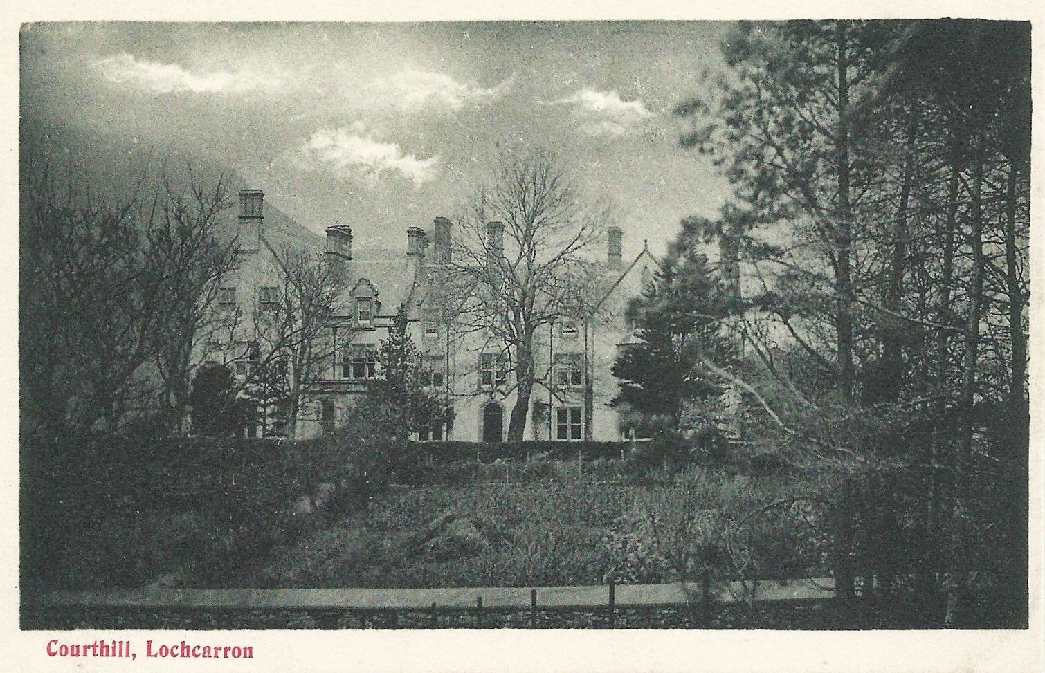
Below is the only picture I've ever seen of Courthill when it was still in use. It was taken in July 1931 and comes from the collection of Robert M Adam held by St Andrews University Photo Archive. [See Update at the end of this post for two more pictures.]


I had to look long and hard at that photograph to reassure myself it was indeed Courthill. But it is - what's in the centre of my photo at the top is off to the left behind the trees but the right hand bit in my photo is what's on the left of the 1931 pic.

As to the history of the house, around the turn of the 18th and 19th centuries, Courthill was the smallest of the three estates which comprised the parish of Lochcarron. It belonged to Major Alexander Macdonald: a great grandson of Sir James Macdonald, 9th chief of the Macdonalds of Sleat, and married to a niece (by another account, a great grand-daughter) of Flora Macdonald, he was also tacksman (tenant) of Monkstadt in Trotternish on Skye where he lived.

An interesting snippet is that this well connected member of Clan Donald held Courthill as feudal vassal of the Earl of Seaforth, the chief of the MacKenzies - in earlier centuries, that might have caused a conflict of clan loyalties but was an irrelevance by the late 18th century.

Major Alexander Macdonald of Courthill & Monkstadt
An overtly English name like "Courthill" in the overwhelmingly Gaelic world of 19th century Wester Ross usually betrays an interesting story. I've not been able to find any explanation except that the name was in existence as early as 1807 when it's marked on Aaron Arrowsmith's map of that year.-

It's interesting to note that it's marked as "Court Hill or Laggandown" on the Arrowsmith map (above). Laggandown also appears on the Roy Maps of the 1740s-50s:-


So Laggandown - which I think is Gaelic for "brown hollow" - was the original name of a place which became known as Courthill. I'd guess an 18th century laird who'd made some money abroad settled there but decided its Gaelic name was too uncouth so he changed it to the name of his English wife's parents' house - or something like that. It's the reverse equivalent today of people buying a house in Wester Ross called "Sea View" and deciding that's too pedestrian and renaming it something more couthy like "Sealladh na Mara" (which I believe to be the Gaelic for "view of the sea").

Who changed the name, I can't discover but we read in a footnote to page 276 of Alexander Mackenzie's magisterial "History of the Macdonalds and Lords of the Isles" (1881) that Major Macdonald of Courthill's eldest son, another Alexander, "was never married. He became insane when a young man by an operation performed on his ears for deafness, and lived principally with his brother Hugh [at Monkstadt], and was quite harmless." Whether that tragic circumstance had anything to do with it, I don't know, but the New Statistical Account for the Parish of Lochcarron compiled in 1836 recorded that there were now only two landowners in the parish which indicates that the Macdonalds had sold Courthill to their neighbours, the MacKenzies of Applecross. (The other landowner was Matheson of Attadale.)

In 1854, Thomas MacKenzie, 9th laird of Applecross, sold the whole of his estates, including Courthill, to the splendidly named Francis Godolphin D'Arcy D'Arcy Osborne, 7th Duke of Leeds.

Arsy-D'Arcy D'Arcy to his friends
The sale was part of a common pattern in the mid 19th century in which native families who had owned their lands for generations sold out to Victorian nouveaux riches. But the Duke of Leeds didn't enjoy his new Scottish estate for long. In 1859, only five years after he had bought it, he died and Applecross passed to his nephew, the equally splendidly named Sackville George Lane Fox, Lord Conyers. Two years later, in 1861, Conyers sold the Applecross estate in lots. The central portion - which included Courthill and became known as Lochcarron Estate extending to 32,450 acres - was bought by Sir John Stuart.  

Approximate boundaries of Lochcarron Estate bought by Sir John Stuart in 1861
Stuart was the son of a family from Ballachulish in Argyll who became a barrister in London, then an MP before becoming a senior judge in the English courts. He retired in 1871 and died in 1876. His grave in the old cemetry next to Courthill House can still be seen.

Sir John Stuart of Lochcarron's grave - photo credit Roddie Macpherson
Sir John was succeeded by his son Dugald Stuart but in 1882, only six years after he came in to his inheritance, he sold Lochcarron Estate to Charles James Murray, the MP for Hastings (as in "Battle of ...". He later moved to be MP for Coventry 1895-1906.)

As to the history of Courthill House (as opposed to its surrounding estate), my main source of information is the scottisharchitects.org website. This merely records that "alterations and repairs" were carried out in 1856 by architect Alexander Ross. I suspect that understates what happened in 1856. I'd guess that hitherto Courthill was an unpretentious Georgian farm house and what Ross did was convert it into a Victorian mansion house. I suspect the Duke of Leeds, having just bought the whole Applecross Estate in 1854, fixed on Courthill as his seat and commissioned Ross to transform it into something befitting his ducal station (perhaps as a conscious departure from the MacKenzies' seat at Applecross itself)

The architects.org website records further additions in 1883 after the Murrays acquired the house and more in 1901 including the addition of a conservatory. Extensions to Courthill can be seen between the 1875 and 1902 editions of the Ordnance Survey Map below. Generally, it seems to have expanded east and north (that's to the right and behind in the photos above):-


Provost of Inverness 1889-95, the architect Alexander Ross, was responsible for a number of Victorian buildings in this part of Scotland including Gairloch Hotel and Duncraig Castle. There's more about him, with a photo, here.

In 1885, Charles Murray's daughter, Elspeth, died aged just 4. In 1900, tragedy afflicted the family again when his eldest son, Lieutenant Alastair Murray of the Grenadier Guards, was killed in action during the Boer War aged 22. Amongst the 1901 additions to Courthill was a chapel which included stained glass windows in memory of Elspeth and Alastair. More information about the chapel with pictures on Undiscovered Scotland.

Picture credit James Yardley

According to the Undiscovered Scotland website linked to above, the Murrays lost part of their fortune during World War I and came to live at Courthill full time as a result. This sort of suggests they were "slumming it in the holiday home" but I don't know what other estates or houses they had. Maybe it was just a case of having to sell the Edinburgh and/or London townhouses. 

C J Murray died in 1929 and his wife four years later. Despite their wealth and privilege, they'd had their fair share of tragedy and worry and apparently the death of Mrs Murray in 1933 was when Courthill was abandoned. [See Update at the end] The Murrays' surviving son, Charles, junior, had meantime [See Update] built himself another, no doubt smaller and more manageable house elsewhere on the estate. I don't know, but I'm guessing that house is Couldoran, a few miles north of Courthill on the road to Shieldaig.

Couldoran with the hills of Applecross behind

Charles Murray, junior, died in 1945 and that was the catalyst for the sale of Lochcarron Estate. It was sold in lots in 1946 and the purchaser of the lot with Courthill House on it, having no use for the house and finding it a liability, took the roof off and sold the lead to avoid having to pay rates on it. I don't know who the ruin belongs to now but the Murray family retained the chapel in 1946 and eventually gifted it to the Scottish Episcopal Church in 1979. It's still in business as a church (with wheelchair access as well) - further details here.

 
 Above is the partially blocked main gate of Courthill. The three stars in the crest are a feature (yellow on blue) in the arms of both the Dukes of Atholl and the Earls of Dunmore, both peerages held by Murrays. The Courthill family are descended from the Dunmores except that the stars in the Atholl and Dunmore arms are both two on top and one underneath contrary to the pattern at the gate of Courthill. I wonder if C J Murray unofficially adopted an ancient Murray motif with a minor adaptation so as not tousurp the arms of his more exalted cousins? Below the crest on the gate is an inscription in Gaelic (I think) but I don't know what it means.

Courthill seen from Google Earth
As I've typed this story about Courthill, I couldn't help thinking about Downton Abbey. The TV series portrays an image of these country houses as being somehow timeless, permanent and enduring. But so often when you dig in to the history, you discover just how ephemeral many of them actually were. Courthill has now stood empty and ruinous for almost as long as it was in use - just 75 years or so from the 1850s to the 1930s.

Picture credit Joe Dunckley
UPDATE 19 February 2018 - thanks very much to all those who've taken the trouble to comment on this post. From these we can deduce that Courthill was abandoned in 1943 rather than 1933. And according to Couldoran Estate's website, that house was built in 1929. Below are two further postcards of Courthill while still complete I've found since I wrote this post:-