In the 1970s, I recall sailing out from Tobermory north west for the Outer Hebrides into a westerly. The destination was ideally Castlebay on Barra but Lochboisdale on South Uist or even Lochmaddy on North Uist were possibilities if we couldn't point Castlebay. Several hours into a not entirely pleasant experience, I remember calling out in a mixture of triumph and relief "I can see the lighthouse on Oigh-sgeir!" (Wrongly pronouncing it "Oy Skeer" - it's actually "Hesker") And my father replied "Aye, but it's not Oigh-sgeir we need to worry about, it's the Mills Rocks."
These are an unmarked reef about 2 miles south west of the lighthouse - potentially right in the path of a yacht bound for Castlebay inevitably being deflected northwards by the wind, tide and lee-way in the days before GPS.
I can't remember now whether we made Castlebay or ended up in Lochboisdale - the Acarseid Mor (Gaelic for "big anchorage") on Eriskay in between the two is another possibility. But the name of "the Mills Rocks" has stuck in my mind ever since.
Not least because of the overtly English name of this reef compared with others I recall from my sailing days in the 70s and 80s such as Bo Faskadale, Bo Vich Chuan, Sgeir Inoe, Dhubh Hirteach et al.
There is another English named rock I can think of - the Lady Rock at the southern entrance to the Sound of Mull. It's allegedly so called because some MacLean chief of old abandoned his faithless Campbell wife (might be the other way round) there to be drowned by the incoming tide. But I've always assumed this to be apocryphal because, if true, why is the name of the rock English rather than Gaelic as reflecting the times?
But there's no doubting the provenance of the name of the Mills Rocks as I chanced upon while browsing maps at National Libraries of Scotland website the other day: Thomas Kitchin's A new and complete map of Scotland and islands thereto belonging of 1773 tells us exactly why the Mills Rocks are so called:-
Another old map on the NLS website notes the rocks were discovered in 1731 rather than 1733 but I can't remember which map that was so can't link to it - if you've got the time to spare, you could probably while away a pleasant few hours looking for it.
Meanwhile, back in the 20th century, I recall in 1988 being on a Calmac ferry (the MV Claymore (1978)) en route from Lochboisdale to Oban and she passed to the north of Oigh-sgeir which is a slight deviation north of the direct route. I wonder if that was due to a desire to be sure of avoiding Mills Rocks to the south of Oigh-sgeir? Do today's ferries with the benefit of GPS still make a similar detour? (Can they pronounce it correctly?)
Actually, now that I think about this, there are other English named rocks. There's a Jemima Rock on the chart above and I can think of Eugenie Rock and Comet Rock between Skye and Harris. All doubtless have tales to tell.
Thursday, October 11, 2012
Monday, September 17, 2012
Lochboisdale
A few years ago, I wrote a series of articles about Peter's Port, the pier built in 1896 to serve the island of Benbecula in the Outer Hebrides.
The plan was to avoid traffic for Benbecula having to land at Lochboisdale or Lochmaddy piers and then brave the hazardous crossing of "the fords", as the tidal strands separating the island from its neighbours are known. But Peter's Port Pier ended up being a bit of a white elephant due to MacBrayne's refusing
to call there on account of it not being equipped with any
navigation lights or marks and consequently difficult of approach for
their steamers. This most local of spats even led to regular questions being asked in the House of Commons until the issue was eventually overtaken by construction of
a road bridge linking Benbecula to South Uist in 1939.
Another criticism levelled at Peter's Port Pier in its early years was that it wasn't actually on Benbecula at all. In fact, it was on an off-lying islet which, for the first decade of the pier's existence, wasn't even connected to its parent island by a bridge or causeway! And the reason for harking back to Peter's Port is that I've found another example of this apparently most bizarre of all creatures - a pier with no road to it. By coincidence, it's at Lochboisdale:-
Zooming out a bit puts that in context and shows it's not the present ferry pier before surrounding present day detail, such as the Lochboisdale Hotel etc., had been filled in. The map extract below from the OS 25 inch map of 1903 (click to enlarge) shows the "roadless pier" at bottom right with the present day ferry pier and hotel at top right.
The old pier is still clearly visible on Bing Maps (which I note in passing has just recently added some new high resolution aerial imagery of this part of the Outer Hebrides):-
It's even still marked on modern OS maps as a "jetty":-
The old pier at Lochboisdale is not, however, recorded on the Pastmap website of antiquities which I suspect maybe a bit of an omission. So I have no idea what its history is and it's pure guess-work when I conjecture it could date to the kelping era of the late 18th/early 19th centuries.
Kelping was the gathering of seaweed and burning it to derive a material ("kelp") from which chemicals were extracted for industrial processes such as the manufacture of soap and glass. A topic deserving a blog entry of its own (a book indeed), kelping had a profound effect on the economy of the western seaboard of Scotland before it collapsed in the 1820s when it became cheaper to import the same chemicals from countries Britain had hitherto been at war with in the Napoleonic Wars. During its heyday c.1790-1820, kelping was responsible for creating the crofts (allotments for part time kelpers, essentially) which remain such a feature of north west Scotland to the present day.
Let's not digress in to kelping too much - my guess is the old pier in Loch Boisdale was a trans-shipment point to where kelp (the crystalline product of burnt raw seaweed) was brought in small boats from around the coast of South Uist to be loaded on to bigger boats - sailing smacks most likely - for transport south to Glasgow or Liverpool.The point is that kelping, being an essentially coastal business, had no need of roads to any piers. It was only later in the 19th century, in changed economic circumstances when roads were built on South Uist, that the village of Lochboisdale we know today developed around its road/shipping trans-shipment point at the pier which remains as today's ro-ro ferry terminal.
The point is a pier with no road is not as daft an idea as it sounds if you go back to an era before travel by road - facilitated by the internal combustion engine from the beginning of the 20th century - became the norm. (The problem with Peter's Port pier was it was built just as road transport was coming in to vogue.)
This is all very topical as far as Lochboisdale is concerned because planning permission was granted in October 2011 for the construction of a new harbour on the island of Gasaigh (the one at top left of the photo above).
Clearly having learnt the lessons of Peter's Port, the plans include a causeway out to the island via Rubha Bhuailt (Gaelic for "cattle fold peninsula", I believe) past the site of our old roadless pier:-
Promoted by Storas Uibhist, the community landowner of South Uist, the project includes breakwaters to enclose pontoons for fishing and leisure use. It's going to cost about £10m to be paid for by a variety of public and lottery etc. sources. Last I heard was the funding package had been assembled but I'm not sure when work actually begins or when it's planned to be completed. I was going to suggest looking at Storas Uibhist's website for the latest news but I see they haven't updated since December 2011. I'm not sure if that's good news or means the thing's stalled, or what ...
I gather also that these proposals are just the first phase of a bigger plan involving the ferry terminal being moved out from its current location together with housing and industrial units and even a cruise ship terminal on Gasaigh.
I understand that CMAL (the Scottish Government owned company which owns the ships and ports operated by Calmac) have objected to the application for a statutory Harbour Order for the project - could this be an echo of MacBrayne's refusal to countenance Peter's Port? And has the County Archivist insisted on a condition to protect the historical significance of the old road-less pier on Rubha Bhuailt?
Could the Lochboisdale scheme end up going the same way as the ambitious plans for Kyle of Lochalsh in 1950 (pictured above) I wrote about a couple of years ago (link to that here), that's to say only partially completed and not fulfilling its whole potential?
Whatever, I leave you with an exceptional picture of Loch Boisdale (taken by South Uist native and very nice man Allan Macdonald) showing the Calmac ferry MV Lord of the Isles steaming down the loch bound for Castlebay and Oban. That's the island of Gasaigh behind the ferry where the new harbour etc. is planned.
I wonder what the view in Allan's photo will look like in five year's time? Maybe these guys know:-
![]() |
| OS Quarter Inch Map, 1922 |
Another criticism levelled at Peter's Port Pier in its early years was that it wasn't actually on Benbecula at all. In fact, it was on an off-lying islet which, for the first decade of the pier's existence, wasn't even connected to its parent island by a bridge or causeway! And the reason for harking back to Peter's Port is that I've found another example of this apparently most bizarre of all creatures - a pier with no road to it. By coincidence, it's at Lochboisdale:-
![]() |
| OS 25 inch scale map, surveyed 1878 |
![]() |
| Map by National Libraries of Scotland |
It's even still marked on modern OS maps as a "jetty":-
The old pier at Lochboisdale is not, however, recorded on the Pastmap website of antiquities which I suspect maybe a bit of an omission. So I have no idea what its history is and it's pure guess-work when I conjecture it could date to the kelping era of the late 18th/early 19th centuries.
Kelping was the gathering of seaweed and burning it to derive a material ("kelp") from which chemicals were extracted for industrial processes such as the manufacture of soap and glass. A topic deserving a blog entry of its own (a book indeed), kelping had a profound effect on the economy of the western seaboard of Scotland before it collapsed in the 1820s when it became cheaper to import the same chemicals from countries Britain had hitherto been at war with in the Napoleonic Wars. During its heyday c.1790-1820, kelping was responsible for creating the crofts (allotments for part time kelpers, essentially) which remain such a feature of north west Scotland to the present day.
Let's not digress in to kelping too much - my guess is the old pier in Loch Boisdale was a trans-shipment point to where kelp (the crystalline product of burnt raw seaweed) was brought in small boats from around the coast of South Uist to be loaded on to bigger boats - sailing smacks most likely - for transport south to Glasgow or Liverpool.The point is that kelping, being an essentially coastal business, had no need of roads to any piers. It was only later in the 19th century, in changed economic circumstances when roads were built on South Uist, that the village of Lochboisdale we know today developed around its road/shipping trans-shipment point at the pier which remains as today's ro-ro ferry terminal.
The point is a pier with no road is not as daft an idea as it sounds if you go back to an era before travel by road - facilitated by the internal combustion engine from the beginning of the 20th century - became the norm. (The problem with Peter's Port pier was it was built just as road transport was coming in to vogue.)
![]() |
| Red arrow shows the old pier in relation to the modern Lochboisdale village and pier: photo credit RCAHMS |
Clearly having learnt the lessons of Peter's Port, the plans include a causeway out to the island via Rubha Bhuailt (Gaelic for "cattle fold peninsula", I believe) past the site of our old roadless pier:-
Promoted by Storas Uibhist, the community landowner of South Uist, the project includes breakwaters to enclose pontoons for fishing and leisure use. It's going to cost about £10m to be paid for by a variety of public and lottery etc. sources. Last I heard was the funding package had been assembled but I'm not sure when work actually begins or when it's planned to be completed. I was going to suggest looking at Storas Uibhist's website for the latest news but I see they haven't updated since December 2011. I'm not sure if that's good news or means the thing's stalled, or what ...
I gather also that these proposals are just the first phase of a bigger plan involving the ferry terminal being moved out from its current location together with housing and industrial units and even a cruise ship terminal on Gasaigh.
I understand that CMAL (the Scottish Government owned company which owns the ships and ports operated by Calmac) have objected to the application for a statutory Harbour Order for the project - could this be an echo of MacBrayne's refusal to countenance Peter's Port? And has the County Archivist insisted on a condition to protect the historical significance of the old road-less pier on Rubha Bhuailt?
Could the Lochboisdale scheme end up going the same way as the ambitious plans for Kyle of Lochalsh in 1950 (pictured above) I wrote about a couple of years ago (link to that here), that's to say only partially completed and not fulfilling its whole potential?
Whatever, I leave you with an exceptional picture of Loch Boisdale (taken by South Uist native and very nice man Allan Macdonald) showing the Calmac ferry MV Lord of the Isles steaming down the loch bound for Castlebay and Oban. That's the island of Gasaigh behind the ferry where the new harbour etc. is planned.
I wonder what the view in Allan's photo will look like in five year's time? Maybe these guys know:-
Friday, September 7, 2012
Shuna Castle
![]() |
| Picture credit extra-minty |
Something I've always been interested in is small islands with disproportionately large and grandiose houses on them. At 1,100 acres (450ha), the island of Shuna, 15 miles (25km) south of Oban, is relatively big compared to its house in the spectrum I'm thinking about but Shuna House is the only example of the genre I've ever had afternoon tea in.
![]() |
| Mapping from National Libraries of Scotland |
![]() |
| The north end of Shuna before the "castle" was built as seen on the OS 6 inch map of 1880 |
![]() |
| Mr Speaker Gully as cariacatured in Vanity Fair in 1896 |
Said to have cost £300,000 (about £30 million in today's prices), the architect of Shuna House, according to the Buildings at Risk Register, was a local, Neil Gillies from Lochgilphead. He is said to have died on the Titanic - more about him here where it's interesting to note his connection to the nearby Crinan Hotel.
![]() |
| Picture credit Andy Holmfirth |
An attractive, vivacious lady in her mid 30s, a native of Iona, Fiona wasn't Viscountess Selby. Her husband was the younger brother of the then Viscount. I don't know what internal family arrangements had led to this "cadet branch" of the Gullys living on Shuna while the Viscount Selby of the day lived nearby on mainland Argyll. It doesn't matter because the Hon. Mrs James Gully (to give her her formal title) welcomed us into Shuna House irrespective of the details of her tenure.
We were given cups of tea in a cluttered but homely room. It obviously wasn't "the drawing room" and Fiona made no bones about the fact that the deteriorating condition of the house which her family were having increasing difficulty maintaining obliged them to retreat progressively into an ever smaller number of habitable rooms. I vividly recall a toddler trundling round the room on a tricycle ramming the furniture. Fiona interrupted the conversation to admonish the child: "Darling, please don't do that!" before turning back to her guests and saying, in a tone of charming self deprecation "It's Queen Anne, you know!"
![]() |
| Shuna House on Google Earth - the fact the road runs to the farm buildings but doesn't continue to the house suggests nobody's at home anymore. |
According to this website, it's the fact that Shuna House was flat roofed that had a lot to do with it being such a nightmare to maintain. In the course of googling information for this blog, I discovered an article in the Glasgow Herald in 1987. It reports that Edward Gully was being challenged by the Council for not having planning permission for the caravan he kept on the adjacent mainland to sleep in on the nights when he couldn't get over to Shuna (no public ferry) and it was too long a drive back round home to Seil. The point of mentioning this is the horrid irony that the article is next to an advert for "A permanent answer to leaking flat roofs":-
Too late for Shuna House, alas!
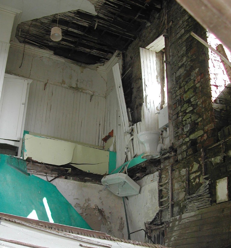
I was prompted to write this blog post by having chanced on this set of photos on Flickr showing the empty Shuna House in an advanced state of decay. Of these, the most arrestingly sad was the one below of the bathroom furniture clinging precariously to the walls after the floor beneath them had collapsed:-
![]() | |
| Photo credit extra minty |
Also in the course of googling the "research" for this post, I was sorry to find that Fiona Gully died in May 2012, far too young at 68. Another rather sad little coda to the tale was to learn of the death in a car crash in 2001 of Fiona's husband's nephew, Edward, the 5th Viscount Selby at the even younger age of 33. Noting that he was living on Mull at the time while his mother occupied the "family seat" at Ardfern, on mainland Argyll close to Shuna, Lord Selby's obituary in the Glasgow Herald also recorded that, having been a financier, he had been working latterly as a check out operator in the Tobermory and Oban branches of the Co-op.
![]() |
| Shuna House - photo credit rosyb |
So far as I know, Fiona Gully's husband still owns Shuna and farms it in partnership with their sons. You can hire a holiday cottage there - see the island's website.
![]() |
| Photo credit extra-minty |
Monday, August 6, 2012
Tobermory
I've found what I think must be the second earliest (I'll come to the earliest later) picture of Tobermory I've ever seen.
It's a vignette on an 1847 Admiralty Chart of Tobermory Harbour showing the southern entrance to the harbour.
What caught my eye about it is, note how the buildings along the seafront stop half way along looking from left to right (south west to north east). Compare with the present day view from roughly the same angle where the buildings go all the way along:-
The chart the vignette appears on (pictured above) shows buildings along the whole length of the present sea front as far as Mishnish Pier instead of stopping where it says "Inn" at the long narrow pier half way along which is where the vignette shows the buildings stopping. This all suggests to me that the vignette was drawn many years before 1847 when the chart was drawn for reasons that are hinted at by Tobermory's history.
The village was developed in the 1780s by the ponderously named "British Society for Extending the Fisheries and Improving the Sea Coasts of the United Kingdom". Incorporated by Act of Parliament and usually known as the British Fisheries Society (BFS) for short, it operated by buying land at sites it thought would make good fishing ports and leasing plots to fishermen and tradesmen associated with the fishing industry to build houses and fish curing sheds etc. The BFS also established Ullapool and Wick on the same basis.
At Tobermory, then virtually a virgin site, the BFS bought 2,000 acres of land in two adjoining parcels - one at the west (inner, left hand) end of the bay from the Duke of Argyll and the other, at the east (outer, right hand) end, from Mishnish Estate. The dividing line between the two was at the long thin pier which projects south on the chart (the one opposite the clock tower and the Co-op - I don't know if it has a name locally).
It was only the first of these two parcels - the west one acquired from the Duke of Argyll - which was originally developed by the BFS in the 1780s. This is confirmed by the picture which I think must be the earliest of Tobermory (although I think it's more of an artist's impression of how the village would look rather than an actual "as built" view as I believe the vignette on the chart is).
The rest of the buildings along the seafront - those to the east (right) on the land acquired from Mishnish Estate - were not developed until the 1820s. This most recognisably "Balamory" part of Tobermory (pictured below) was, in fact, a "Phase 2" of the village and it's no coincidence that it's this part that includes Mishnish Pier and the Mishnish Hotel (the yellow building).
Although it became a thriving commercial centre, Tobermory was never particularly successful as a fishing village. For that reason, the BFS sold it in 1844 back to the two estates it had originally acquired the land from - Aros Estate to the south east (though no longer owned by the Duke of Argyll in the 1840s) and Mishnish Estate to the north west.
After various changes of ownership, Aros Estate - still including the west and original part of Tobermory - was bought by the Forestry Commission in 1971. It always strikes me as one of these ironies of history that land bought in the 1780s by a body incorporated by Act of Parliament for the purposes of fishing ended up being bought nearly 200 years later by a body incorporated by Act of Parliament for the purposes of forestry. I suspect the north of Mull ended up being more fertile territory for forestry than fishing but it's harder to judge which body brought more lasting long term benefits ...
Below is a map (taken from the excellent map viewer on the Forestry Commission's website) showing in green the land the FC still owns around the village as parts of Aros Estate. Many areas have been sold off but note the north east boundary at the old pier opposite the Co-op preserving to this day the historical dividing line between the two phases of development of Tobermory in the late 18th and early 19th centuries:-
[Boring technical note it's not complulsory to read - the map shows a lot of the centre of Tobermory shaded green as if the FC owned all the houses etc. This is more illusory than real. What the BFS sold in 1844 was the freehold (i.e. landlord's interest) of the house etc. plots held on long lease by the villagers. In the late 19th/early 20th century, when Aros Estate was owned by the Allan family, most of these leaseholds were converted to feus. A peculiarly Scottish institution, feus were, in effect, perpetual leases held for a ground rent known as feuduty (usually just a few pounds a year for a house). The freehold of a feu (the right to receive the feuduty) was called the "superiority" and the leaseholders were known as "feuars". What the FC acquired in 1971 was the superiorities of the village. Superiorities were abolished in 2004 (meaning the feuars became the freeholders) so in due course the FC will have to update the map to remove the parts they were only the superiors of]
It's a vignette on an 1847 Admiralty Chart of Tobermory Harbour showing the southern entrance to the harbour.
What caught my eye about it is, note how the buildings along the seafront stop half way along looking from left to right (south west to north east). Compare with the present day view from roughly the same angle where the buildings go all the way along:-
![]() |
| Photo credit dplatten |
![]() |
| The buildings at the east end of Tobermory and Mishnish Pier which are missing from the vignett |
The village was developed in the 1780s by the ponderously named "British Society for Extending the Fisheries and Improving the Sea Coasts of the United Kingdom". Incorporated by Act of Parliament and usually known as the British Fisheries Society (BFS) for short, it operated by buying land at sites it thought would make good fishing ports and leasing plots to fishermen and tradesmen associated with the fishing industry to build houses and fish curing sheds etc. The BFS also established Ullapool and Wick on the same basis.
![]() |
| Tobermory Bay in 1775 before development of the village by the BFS. Plan by Murdoch MacKenzie viewable on the National Libraries of Scotland websit |
At Tobermory, then virtually a virgin site, the BFS bought 2,000 acres of land in two adjoining parcels - one at the west (inner, left hand) end of the bay from the Duke of Argyll and the other, at the east (outer, right hand) end, from Mishnish Estate. The dividing line between the two was at the long thin pier which projects south on the chart (the one opposite the clock tower and the Co-op - I don't know if it has a name locally).
It was only the first of these two parcels - the west one acquired from the Duke of Argyll - which was originally developed by the BFS in the 1780s. This is confirmed by the picture which I think must be the earliest of Tobermory (although I think it's more of an artist's impression of how the village would look rather than an actual "as built" view as I believe the vignette on the chart is).
![]() |
| Scan of Plate 2 in "The British Fisheries Society" 1786-1893 by Jean Dunlop |
The rest of the buildings along the seafront - those to the east (right) on the land acquired from Mishnish Estate - were not developed until the 1820s. This most recognisably "Balamory" part of Tobermory (pictured below) was, in fact, a "Phase 2" of the village and it's no coincidence that it's this part that includes Mishnish Pier and the Mishnish Hotel (the yellow building).
![]() |
| Photo credit Yorkshire Girl |
Although it became a thriving commercial centre, Tobermory was never particularly successful as a fishing village. For that reason, the BFS sold it in 1844 back to the two estates it had originally acquired the land from - Aros Estate to the south east (though no longer owned by the Duke of Argyll in the 1840s) and Mishnish Estate to the north west.
After various changes of ownership, Aros Estate - still including the west and original part of Tobermory - was bought by the Forestry Commission in 1971. It always strikes me as one of these ironies of history that land bought in the 1780s by a body incorporated by Act of Parliament for the purposes of fishing ended up being bought nearly 200 years later by a body incorporated by Act of Parliament for the purposes of forestry. I suspect the north of Mull ended up being more fertile territory for forestry than fishing but it's harder to judge which body brought more lasting long term benefits ...
Below is a map (taken from the excellent map viewer on the Forestry Commission's website) showing in green the land the FC still owns around the village as parts of Aros Estate. Many areas have been sold off but note the north east boundary at the old pier opposite the Co-op preserving to this day the historical dividing line between the two phases of development of Tobermory in the late 18th and early 19th centuries:-
[Boring technical note it's not complulsory to read - the map shows a lot of the centre of Tobermory shaded green as if the FC owned all the houses etc. This is more illusory than real. What the BFS sold in 1844 was the freehold (i.e. landlord's interest) of the house etc. plots held on long lease by the villagers. In the late 19th/early 20th century, when Aros Estate was owned by the Allan family, most of these leaseholds were converted to feus. A peculiarly Scottish institution, feus were, in effect, perpetual leases held for a ground rent known as feuduty (usually just a few pounds a year for a house). The freehold of a feu (the right to receive the feuduty) was called the "superiority" and the leaseholders were known as "feuars". What the FC acquired in 1971 was the superiorities of the village. Superiorities were abolished in 2004 (meaning the feuars became the freeholders) so in due course the FC will have to update the map to remove the parts they were only the superiors of]
Tuesday, July 31, 2012
Hynish
At the end of the B8066 at the south west end of Tiree, you come across a group of early-Victorian buildings with an incongruously instutional look about them in the surrounding Hebridean crofting landscape:-
Looking like a cross between a prison camp and a work house, if this was in the Channel Islands, you could imagine they held some dark secret of the Nazi occupation but this is, in fact, Hynish, the shore base for the construction of the Skerryvore Lighthouse.
Built between 1838 and 1844 under the supervision of engineer Alan Stevenson (uncle of the author of Treasure Island, Robert Louis Stevenson), Skerryvore is built of granite quarried on Mull which was brought to Hynish to be shaped into blocks before being shipped out to the reef 10 miles (16km) south west of Tiree and incorporated into the rising structure of the lighthouse.
I first learnt about Hynish in 1994 when I visited Tiree on holiday. The signal tower which communicated by semaphore with the workers on the rock is a museum about the construction of the lighthouse while the keepers' houses are now affordable homes for Tiree residents. The remainder of the buildings form the Hynish Centre run by the Hebridean Trust for holding conferences and courses etc.
But what I didn't know about Hynish until the other day is that the harbour there (pictured above) was a wet dock. I've seen it referred to as a dry dock but it was exactly the opposite - a wet dock - because it could be kept full of water when the tide was out by closing lock gates (which have since disappeared) across the mouth of the dock. You can see the grooves the gates were located in in the photo below.
The point of it being a wet dock was that it was much easier to load boats with the heavy granite blocks for the lighthouse if they could be kept afloat at a constant level next to the pier rather than going up and down with the tide and drying out at low water.
Even more interesting is that the wet dock at Hynish didn't rely on a high tide to be filled up but was equipped with an onshore reservoir of fresh water to fill it. You can see the whole arrangement clearly on the OS 25 inch map of 1878 when the wet dock was apparently still in operation:-
What always strikes me about these things is that Victorian engineers like Stevenson - with no GPS or internet or software and presumably just pencil and paper - had to think about stuff like the shore base as well as the lighthouse on the rock. The wet dock would have been quite an achievement on its own!
The reservoir with its associated dam and sluice are also still clearly visible on Google Earth:-
You can see them quite clearly on the ground as well:-
The point of this post is I think it's fascinating to discover examples of such quintessential Victorian engineering as a wet dock (albeit on a small scale) in such a remote location as Tiree. And in such a state of preservation. Also, how it's possible to go for a virtual look round the past and the present without leaving my seat here in the Azores courtesy of such resources as Google Earth and National Libraries of Scotland Maps. But if you are actually going to Tiree any time soon, do go up on that dam and take a few photos and add them to Canmore.
Looking like a cross between a prison camp and a work house, if this was in the Channel Islands, you could imagine they held some dark secret of the Nazi occupation but this is, in fact, Hynish, the shore base for the construction of the Skerryvore Lighthouse.
Built between 1838 and 1844 under the supervision of engineer Alan Stevenson (uncle of the author of Treasure Island, Robert Louis Stevenson), Skerryvore is built of granite quarried on Mull which was brought to Hynish to be shaped into blocks before being shipped out to the reef 10 miles (16km) south west of Tiree and incorporated into the rising structure of the lighthouse.
![]() |
| Hynish and Skerryvore on the Scotland - West Coast admiralty chart |
![]() |
| Skerryvore Lighthouse - photo credit Ian Cowe |
I first learnt about Hynish in 1994 when I visited Tiree on holiday. The signal tower which communicated by semaphore with the workers on the rock is a museum about the construction of the lighthouse while the keepers' houses are now affordable homes for Tiree residents. The remainder of the buildings form the Hynish Centre run by the Hebridean Trust for holding conferences and courses etc.
![]() |
| Hynish Wet Dock - picture credit Clyde Cruising Club |
![]() |
| Hynish by Niall Corbet |
Even more interesting is that the wet dock at Hynish didn't rely on a high tide to be filled up but was equipped with an onshore reservoir of fresh water to fill it. You can see the whole arrangement clearly on the OS 25 inch map of 1878 when the wet dock was apparently still in operation:-
What always strikes me about these things is that Victorian engineers like Stevenson - with no GPS or internet or software and presumably just pencil and paper - had to think about stuff like the shore base as well as the lighthouse on the rock. The wet dock would have been quite an achievement on its own!
The reservoir with its associated dam and sluice are also still clearly visible on Google Earth:-
You can see them quite clearly on the ground as well:-
The point of this post is I think it's fascinating to discover examples of such quintessential Victorian engineering as a wet dock (albeit on a small scale) in such a remote location as Tiree. And in such a state of preservation. Also, how it's possible to go for a virtual look round the past and the present without leaving my seat here in the Azores courtesy of such resources as Google Earth and National Libraries of Scotland Maps. But if you are actually going to Tiree any time soon, do go up on that dam and take a few photos and add them to Canmore.
![]() |
| Extract from OS 1 inch sheet 44 Coll & Tiree |
Sunday, July 29, 2012
Another trawl through Flickr: The Outer Isles Mail
I've uncovered another absolute cracker of a photo in the course of another of my periodic sessions on Flickr
That picture by Sandy Stevenson shows a car being craned off MacBrayne's MV Lochmor (1930) at Tarbert, Harris. It's interesting to contrast it with vehicles coming off a Calmac ship at a Hebridean port in the 21st century:-
I uploaded a picture to my own Flickr photostream the other night of a scan of a 1955 MacBrayne's brochure. What caught my eye was that it said - almost as an afterthought - "MOTOR CARS. These can be conveyed by
prior arrangement on most steamer routes." How times have changed!
Going back to the picture of the Lochmor at Tarbert at the top, there's a detail in it that allows the photo to be dated quite closely. Note how the hull of the ship (the bit round the three round portholes at bottom left) is grey rather than the usual MacBrayne's black. That tells us the photo was taken in 1930 or 1931 when the Lochmor was brand new.
The reason is that the 1920s had seen MacBrayne's in financial difficulties culminating in their withdrawing their tender for the vital mail contract to the Western Isles in 1928. As nobody else had tendered either, that would be the equivalent today of nobody - not even Calmac - bidding for the subsidy to run the car ferry services to the islands. The government therefore brokered a solution whereby MacBrayne's was taken over from the MacBrayne family by a consortium between Coast Lines (a shipping company specialising in trade around the Irish Sea; it was eventually taken over by P&O in the early 70s) and the London Midland & Scottish Railway. This new management attempted a rebranding exercise (as we would call it today) of re-painting the fleet's hulls light grey but it didn't catch on and they reverted to the traditional black in 1931.
The Lochmor also called at Lochmaddy but sailed from Mallaig and Kyle of Lochalsh rather than Uig on a 24 hour circuit round Skye (clockwise and anti-clockwise on alternate days) known as "the Outer Isles Mail". It also included calls at Scalpay, Stockinish (Harris), Rodel (these last two being ferry calls), Lochboisdale, Canna, Rum and Eigg.
The Outer Isles Mail service ceased in 1964 when it was replaced by the new car ferry service running from Uig to just Tarbert and Lochmaddy. Scalpay and the Small Isles (Eigg, Rum & Canna) got their own dedicated services. The Lochmor was sold for further service in the Aegean. Her replacement on the new "Uig Triangle" service was the Hebrides (II) which served the route until 1985 and, as we're in a "then and now" mood, I'll finish with a picture of her followed by one of the current ferry to Tarbert and Lochmaddy, the Hebrides (III) both in the same position canting (turning) to approach the pier at Uig.
That picture by Sandy Stevenson shows a car being craned off MacBrayne's MV Lochmor (1930) at Tarbert, Harris. It's interesting to contrast it with vehicles coming off a Calmac ship at a Hebridean port in the 21st century:-
![]() |
| MV Clansman at Castlebay by Michael McIntyre |
Going back to the picture of the Lochmor at Tarbert at the top, there's a detail in it that allows the photo to be dated quite closely. Note how the hull of the ship (the bit round the three round portholes at bottom left) is grey rather than the usual MacBrayne's black. That tells us the photo was taken in 1930 or 1931 when the Lochmor was brand new.
The reason is that the 1920s had seen MacBrayne's in financial difficulties culminating in their withdrawing their tender for the vital mail contract to the Western Isles in 1928. As nobody else had tendered either, that would be the equivalent today of nobody - not even Calmac - bidding for the subsidy to run the car ferry services to the islands. The government therefore brokered a solution whereby MacBrayne's was taken over from the MacBrayne family by a consortium between Coast Lines (a shipping company specialising in trade around the Irish Sea; it was eventually taken over by P&O in the early 70s) and the London Midland & Scottish Railway. This new management attempted a rebranding exercise (as we would call it today) of re-painting the fleet's hulls light grey but it didn't catch on and they reverted to the traditional black in 1931.
![]() |
| A grey hulled Lochmor at Kyle of Lochalsh in the early 30s |
![]() | ||||
| The Outer Isles Mail timetable in 1934 (click to enlarge) |
![]() | ||
| The route of the Outer Isles Mail service |
![]() |
| The Lochmor with traditional black hull at Lochmaddy |
The Outer Isles Mail service ceased in 1964 when it was replaced by the new car ferry service running from Uig to just Tarbert and Lochmaddy. Scalpay and the Small Isles (Eigg, Rum & Canna) got their own dedicated services. The Lochmor was sold for further service in the Aegean. Her replacement on the new "Uig Triangle" service was the Hebrides (II) which served the route until 1985 and, as we're in a "then and now" mood, I'll finish with a picture of her followed by one of the current ferry to Tarbert and Lochmaddy, the Hebrides (III) both in the same position canting (turning) to approach the pier at Uig.
![]() |
| MV Hebrides (II) (1964) approaching Uig pier |
![]() |
| MV Hebrides (III) (2001) at Uig - picture credit Alpha Deux Cents |
Subscribe to:
Posts (Atom)