Friday, April 19, 2013

Cabuie Lodge (Loch Fannich)

I've always been fascinated by the changes to the landscape brought about by the North of Scotland Hydro Electricity Board's schemes in the 1940s and 50s.

The most obvious impacts were the dams and flooding of glens to create reservoirs; the power stations and the pylons. But of equal, if not more, interest to me are the more minor things like the rivers, roads and even railways that were diverted to make way for the rising waters. And the houses which were demolished, from shepherds' cottages to shooting lodges.

Picture reproduced by kind permission of Helen Murchison of Achintraid
Such was the fate of Cabuie Lodge, pictured above, which was demolished in about 1950 when the loch it stood at the head of, Loch Fannich in Wester Ross, was converted into a hydro-electric reservoir.


Despite the conversion, the site of the lodge and its associated estate buildings appear to have remained "high and dry" with piles of rubble representing their remains being still clearly visible on aerial photography:-


Below is Cabuie Lodge the OS 6 inch map of 1902:-

OS 6 inch Ross & Cromarty Sheet LX, Publication date: 1905; Date revised: 1902
It's interesting to compare with the earlier, 1875 6 inch map below which shows that the lodge hasn't been built yet - right enough, it does look to be of a late Victorian style of architecture:-

Ross-shire & Cromartyshire (Mainland), Sheet LX Survey date: 1875; Publication date: 1881
The chances are, therefore, if it was built around 1890 as the maps suggest, that Cabuie Lodge has now been gone for longer than it existed.

I was disappointed the Geograph website didn't have an up close ground level photo of the remains of Cabuie but it does have a good picture of the site at the head of the loch from up on the hillside to the south:-

Photo credit Andrew Spenceley
And a splendid picture of an old cast iron way marker to the lodge near the south shore of the loch - I've never seen one of these before:-

Picture credit John Allan
Meanwhile, half way along the north shore on a different estate, Fannich Lodge was high enough above the shoreline to survive the loch's "hydro-fication":-

Picture credit jwvdh

Ross & Cromarty Sheet LXXIII, Publication date: 1905; Date revised: 1902
Now, until recently, I have to confess to astonishing ignorance about hydro-electric reservoirs. I'd always assumed they just generated electricity from the pressure of water at the foot of the dam, thus:-

Laggan Dam - picture credit John Stewart
But if that were so, then why is there never a power station next to the dam? Hydro power stations are usually a few miles away from the reservoirs which supply them. And to judge from the Google Earth imagery, it looks as if the water level in Loch Fannich seldom, if ever reaches the dam so how does it ever generate electricity?:-


Fannich Dam - picture credit Hugh Venables
In fact, hydro-electric generation is not about how much water you can pile up behind a dam but rather a function of the vertical drop between the water and the turbine - the bigger the drop, the more the power. Thus, the ideal arrangement is for the power station (containing the turbine) to be in a neighbouring but lower glen and with the water being led to it through a tunnel like so:-

Apologies for that somewhat artless graphic but I hope it illustrates why the power station which generates electricity from the water in Loch Fannich is the one at Grudie Bridge, 3 miles (5 km) away, on the A832 between Garve and Achnasheen in neighbouring Strath Bran, some 500 feet (160 metres) below the level of Loch Fannich. The loch and the power station are connected by a tunnel for most of the distance and surface pipes down the side of the hill for the final 500 yards.


The RCAHMS entry for Grudie Power Station includes scans of the original 1940s architect drawings showing the thoughtful touches that went into these buildings including the Pictish bear motif above a window:-


But as well as the drop, it's still useful to have a large reservoir of water to make the descent and keep the turbine turning. That's what dams are really about - quantity rather than quality, as it were, in hydro-electric terms. In fact Loch Fannich is unusual in that its water level seldom reaches the dam (and hence why Cabuie Lodge perhaps didn't need to be demolished and its footprint remains visible.) But Fannich exemplifies another thing I hadn't properly realised about Scottish hydro reservoirs which is that they didn't just rely on the natural water catchment area of dammed lochs. In many cases, the Hydro Board artificially enlarged these by diverting the flow of rivers from adjacent catchments to help keep the reservoirs topped up.

Thus, in the case of Loch Fannich, it's natural catchment area is shown outlined in red on the map below. But the areas outlined in orange have been added by trapping streams which would otherwise have flowed off east and west and leading them through pipes (blue lines) back into Loch Fannich.

Below is a picture of the pipe which carries the water flowing off the west-most off the two orange areas east back to Loch Fannich instead of west to Loch Maree where it would naturally flow to:-

Picture credit John Allan
And next is a picture of one of the abstraction points where water from the east-most orange area (which would naturally have flowed down the River Grudie to the Conon) is trapped and sent back west through a pipe into Loch Fannich (visible in the background on the right).

Picture credit Hugh Venables
I'm sorry if this post digressed somewhat from a drowned shooting lodge into hydro-electrics, but I've driven past the Grudie Bridge Power Station more times than I care to remember without ever realising all the interesting stuff going on out of sight in the next glen.

I leave you with a fabulous picture looking west up Loch Fannich from Moray Mountaineering Club's website. Fannich Lodge is clearly visible on the opposite shore of the loch and the site of Cabuie Lodge is at the far top right end of the loch.


Thursday, January 31, 2013

Little Garve Bridge (Wade, Caulfeild and the road to Ullapool)


Little Garve Bridge is something of a hidden treasure. Considering you can drive to (though not across) it and it's less than half a mile from a trunk road, I'm surprised it's not better known. I think it deserves one of these brown tourist attraction signs off the trunk road concerned - the A835 to Ullapool, just past Garve and the junction with the A832 west to Kyle of Lochalsh and Gairloch.

The bridge was built across the River Blackwater (a tributary of the Conon) in about 1762 by Major Caulfeild (that's not a typo - his name was spelt "e before i") as part of a military road from Contin to Poolewe which in the 18th century was the mainland "packet station" (ferry terminus) for Stornoway.

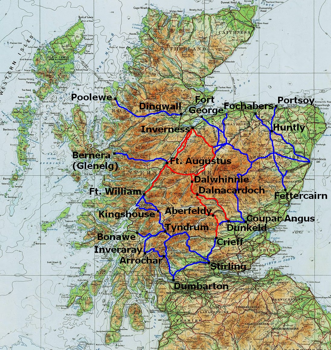
The name of General Wade is synonymous with military roads in the Highlands of Scotland but, in fact, Wade was only responsible for a minority of them. A much greater mileage was executed by his lesser known successor, Major Caulfeild. On the map below, the roads marked red are the Wade roads while the blue ones are Caulfeild's:-

Note that in this map I've mistakenly shown the road to Poolewe as beginning at Dingwall whereas I believe that, in fact, it began at Contin, about 6 miles west of Dingwall

The Wade Roads were built in the 1720s and 1730s. They were a response to the Jacobite Rebellions of 1715 and 1719 when the main theatre of war had been the Highlands but where there were simply no roads (or bridges) along which the army could be deployed to counter the Highland clans which formed the back-bone of the rebel forces. It's often said the principal beneficiary of Wade's roads were, in fact, the Jacobites who used them to move their army around the Highlands during the final rebellion of 1745-46 (Bonnie Prince Charlie, Battle of Culloden). But that didn't deter further military road building under Caulfeild in the 1740s, 50s and 60s.

As peace returned to the Highlands in the later 18th century, many of the less important military roads stopped being maintained. The Contin-Poolewe road seems to have been one of the last to be built and one of the earlier to be abandoned. It's certainly the most elusive in that Little Garve Bridge appears to be the only vestige of it that remains. I can't find the road marked on any map - not even Robert Campbell's "A new and correct map of Scotland or North Britain, with all the post and military roads" published 1790 (pictured above) - and I don't even know its exact route: did it go along the west or east side of Loch Maree, for example? (Note that the Campbell map shows a road along both sides!)


William Taylor in "The Military Roads in Scotland" goes so far as to say "Perhaps the only simple and certain fact about the [Contin-Poolewe] road is that, if it was ever made, it was not built by General Wade". The only other notice I've ever found of it is in "New Ways Through the Glens" by A R B Haldane: he records that the Countess of Seaforth, when travelling in 1799 between (presumably) her home at Brahan Castle (just east of Contin) and Poolewe for the packet (boat) to her husband's estates on Lewis, "could only get as far Loch Achanalt, fifteen miles from Contin, where her coach became a complete wreck".

I think the reason why Little Garve Bridge survived while the rest of the road decayed - although, once again, this is just educated guesswork - is that it was incorporated into a new road built in the mid 1790s at the behest of the British Fisheries Society to their new fishing village of Ullapool established in 1788. But this would only have reprieved the bridge for about 20 years because, when the Highland Roads and Bridges Commission (established in 1803) built its new road from Dingwall to Kyle of Lochalsh ("Kyle-Haken" as it was known then) in the 1810s, it bridged the River Blackwater 6 miles downstream from Little Garve at Contin and went along the south side of the Blackwater and Loch Garve, the route of the present day A835. Presumably, the military road on the north side (blue on the map below) was thereupon abandoned. 


It's worth noting that the original Ullapool road, built in the 1790s, went straight across the hills as shown roughly in red on the map above instead of following the Blackwater as today's A835 does. I'll conclude this post with a description of the old road in George & Peter Anderson's "Guide to the Highlands and Islands of Scotland, including Orkney and Zetland" published in 1842:-

The district road to Loch Broom, and the village of Ullapool on the shores of that loch, strikes off near Garve Inn, proceeding over the high ascent of the Dirie More. Its course may be seen for a mile or so, tending to the north-east of Loch Garve; and then it bends suddenly westward over a very long and bleak ascent, instead of keeping due north, along the Dirie Water [i.e. the River Blackwater] by Achnaclerach and the deer forest of Kirkan, through which it is now proposed to carry an amended line. The distance to Ullapool is about thirty-seven miles. This road was made about fifty years ago, at the expense of government, and cost about £4500, and it was then one of the best roads in the Highlands; but it has for many years been neglected, and is sadly broken down in innumerable places, so as to be passable only to foot passengers and horsemen It conducts across a dreary district called Strath Dirie and the Dirie More, (the long road or step) to the glen at the head of the larger Loch Broom. There are two very indifferent public-houses on the way, the first at Glascarnock, about twelve miles from Strathgarve, and the other at Braemore, a like distance from the former, at which also provisions are not always to be had; ... The mountain torrents which cross the Ullapool road are exceedingly annoying to travellers; and the largest one; the Torran-du river, a little beyond Glascarnock, is not always fordable with safety; but we are glad to hear that this shocking road will not be permitted to remain long in its present condition to disgrace the county of Ross and that the district trustees have at length fairly commenced building bridges, and improving the worst parts. ... At present no vehicle can pass it, and the only expeditious mode of travelling is by riding a country pony or garron. 

Fording the Torran-du (Abhainn an Torrain Duibh) in the 21st century

Tuesday, January 22, 2013

Aros Hotel (Salen Pier)

I have a list of topics to write about on this blog but all too often I find that, in the course of researching a post, I uncover other interesting stuff with the consequence that one topic gets crossed off the list but two have been added! This post attempts to cover two of these extra subjects at once and thereby try to re-establish a bit of equilibrium to the list!

Aros Hotel by George Washington Wilson
I found the photo above of the "Aros Hotel" in the George Washington Wilson archive. Aros is on the east coast of Mull, a couple of miles north of Salen but I found myself thinking "Aros Hotel? Never heard of such an establishment!"


My first thought was it must be the Salen Hotel under a previous name but although the two buildings are similar, the gables, dormers and chimney stacks don't match:-

Salen Hotel - built 1862
Therefore, I think GWW's "Aros Hotel" has to be what's today a private house called the White House of Aros just north of Aros Castle with an alteration to the left-most windows at ground and first floor level and the addition of a new wing on the left hand side:-

White House of Aros - compare the right hand end of this building with the GWW photo.
The identification of the Aros Hotel with the White House is suggested by the Ordnance Survey 6 inch map of 1875 which shows an inn on the site of the White House:-

OS 6 inch map, 1875

The footprint of the building marked as the inn is clearly smaller than that of either GWW's Aros Hotel or today's White House. I suspect it was just the rear (left) wing of the building in the GWW photo. Next, note how the 1897 edition of the 6 inch map shows a building with a much larger footprint which is no longer an inn but is now Aros Lodge. Note also that the pier just to the north is now "Old Pier":-

OS 6 inch map, 1897
note the old pier at top right

What I think happened - and this is no more than educated guess-work - is this: There was a pier with associated inn ("ferry house") at Rudha Ard Ealasaid at Aros established in the late 18th or early 19th century. This would have been one of the principal landings for Mull (especially for traffic crossing from Morvern) but the terminus was moved a mile south to the site of the present day pier at Salen at some point around 1875 (for the OS map of that year does show a pier at Salen). At the same time, the inn at Aros closed and was converted to a private house (and extended). The move was doubtless due to the trend towards piers that steamers could get alongside as opposed to waiting off for a ferry to come out from and perhaps the old pier at Rudha Ard Ealasaid was incapable of improvement. Many West Highland steamer piers were built or improved in the last quarter of the 19th century.

White House of Aros

There's a contemporary account of the Aros Inn in "A Descriptive Tour in Scotland" by the splendidly named Chauncy Townshend who travelled through the west of Scotland in the early 1830s in search, as was fashionable at the time, of places popularised by Sir Walter Scott. Having arrived at Tobermory by steamship (which Townshend snootily dismissed as "floating cake houses" packed with "tiresome tasteless mobs"), he and his companion resolved to continue their voyage to Staffa and Iona then north to Skye on a locally chartered sailing boat. But, as is so often the case, then and now, the weather conspired against the plan and, although they did manage to land on Staffa, the sailing trip had to be abandoned at Bunessan after a miserable two days and a night at sea. From Bunessan, they walked to Aros:- 

Another steep was yet to be surmounted before we reached the neat little inn of Aross [sic.] which looked quiet and comfortable in the moonlight and very inviting to weary travellers. It was now ten o' clock and we had been incessantly on the move since twelve, Henry only occasionally getting a lift on my steed and you know how wretchedly we had past the preceding night. Right glad therefore were we to hear we could be accommodated and to receive the warm welcome of a very model of a Boniface [archaic word for inn-keeper] who, bowing and smiling, showed us into a large room where three tourists were just preparing to take their tea. They had arrived like ourselves weary and hungry but a short time before. ... 

The servant girl here told us last night that, if we wished to go to Skye, the Maid of Ilay steamer would pass Aross at five in the morning, Did we wish to be called? The very thought of such a thing was horrible to us and we begged to be allowed to sleep as long and as late as we possibly could. The very mention of steam boats and voyages redoubled our qualms and made the carpet heave but the girl as if of malice prepense kept assuring us that ths Maid of Ilay was a very braw boat and almost seemed as anxious to speed us on our way as other folks at an inn are generally desirous to keep one stationary. ... The night before we left Aross, we began to think that the people of the house really meant to force us away by incivility. After ringing and ordering supper at least twenty times we gave up the matter in pure despair and at last actually went supperless to bed. The next morning the girl apologised for our having been so badly waited on and accounted for it by telling us that all the time we had been ringing and scolding, her mistress was bringing forth a man child into the world.

More recently, the White House of Aros (with associated estate (42ac/17ha), cottages and salmon fishing on the River Aros) was for sale through estate agents Savills during 2012 at offers over £1.5 million. I assume it must have been sold as it no longer appears on their website.


The picture above - and indeed all of the colour pictures of the White House in this post - are from the Savills sale brochure (which I have in pdf if anyone's interested to see). The vendor must have spent a lot of money on the house because I also have a copy of a brochure from when it was sold in the mid 90s and you can tell the agents then were really struggling to get a semi respectable photo of it!


Now, I began this post by saying I was going to cover two topics and you're maybe wondering by now what the second one is. It's the pier at Salen which replaced the one at Aros. The first Salen pier (seen above on the OS 25 inch map of 1877) was replaced in, I think, the early 20th century by the present one which is at 90 degrees clockwise to the first. But the stumps of the original pier are still clearly visible.

Picture credit kamai00 The White House of Aros is visible directly above the right-most post.
The respective positions of the previous and current piers at Salen. Note that the Bing Maps imagery has a distortion which suggests the bridge out to the berthing head of the current pier has a bend in it when, in fact, it's straight.

Salen was a port of call for MacBrayne's mail steamer which sailed every day from Tobermory to Oban with stops along the way at Drimnin, Lochaline, Craignure and Lismore as well as Salen. The vessel which operated this route from 1908 to 1955 (and intermittently thereafter until she was sold in 1960) was the MV Lochinvar. She is seen below departing from the second (current) Salen Pier in a postcard view dating, I think, from the 1930s:-


From 1955, the regular ship on the Sound of Mull mail service was the Lochearn and she is seen at Salen below:-

Photo credit Craig McDowall
Passenger sailings to Salen would have ceased in 1964 when the Sound of Mull mail service was replaced by the car ferry service from Oban to the new purpose built pier at Craignure. I'm guessing - but don't know - that Salen Pier was kept in commission to serve MacBrayne's cargo sailings but would have been abandoned when these ceased in 1976 (all cargo thereafter going on lorries on the car ferries). At all events, by the 2000s the pier had deteriorated to the point where its buildings had collapsed and it wasn't in much better shape than its predecessor:-

Salen Pier 2008 - picture credit littlebluetortoise

Hence, I was very pleasantly surprised to discover recently (and this is the point of the post) that Salen Pier has been refurbished and brought back into use. You can read about it on their website (which includes some historical photos). This has all, so far as I can tell, been privately funded with no public or lottery money involved. Calmac ships won't ever be calling again but fish farming well-boats can be expected.

loading salmon smolts - picture credit Bentalla
To draw the strands of this post to a close, our 1830s tourist, Chauncy Townshend, crossed from Aros to Lochaline after spending a couple of days at the inn. Of course, it's still possible to cross from Mull to Lochaline but not from Aros or even Salen but now from the slipway at Fishnish 5 miles to the east - the third generation of pier connecting this part of Mull to the mainland.

Fishnish slipway - photo credit Andrew Kesterton

Thursday, November 29, 2012

George Washington Wilson

Remaining with the theme of recording the past but moving on from aquatint to photography, George Washington Wilson (1823-1893) was a commercial photographer from Aberdeen responsible for tens of thousands of photographs taken worldwide including a substantial proportion in Scotland.

His business got an early boost from securing a contract to photograph the Royal Family at the then new Balmoral Castle. The well known photo of Queen Victoria on a pony with her Scottish servant John Brown is a GWW:-

As portrayed in the film "Mrs Brown" (Judi Dench/Billy Connolly), she was alleged to have enjoyed a relationship with Brown more intimate than would be expected between a queen and her servant. You'd never guess from this photo.

Another contender for the most famous GWW must be "the St Kilda Parliament":-


38,000 of GWW's "plates" (I think that's the 19th century equivalent of negatives although we're not far away now from a generation who don't know what "negatives" are either!) were donated by a successor in GWW's business to Aberdeen University in 1958 at a time when they had ceased to have commercial value but their archival value was still pretty latent.

The GWW archive has been available to view online at Aberdeen University's website for some years but, until recently, only in pretty small images not much bigger than a thumbnail. Recently, however, the GWW archive has been re-launched in very high definition allowing you to zoom in on fascinating detail. Go and have a look here.

Needless to say, I've been concentrating on the west coast of Scotland. So far, I've only scratched the surface of the thousands of fascinating images available to view but one particular photo has been a standout for me to date: it's of Oban before the railway arrived in 1880.


Click to go large or go and look at the original where you can zoom in here.

The whole dried out bit on the right hand side of the bay there was built over to form the railway station and railway pier - where the Calmac ferry terminal is now. The street along the seafront on the right (still called "Shore Street" to this day) is now a good 100 metres back from the sea. Note also how few houses there are on the hillside behind - and no McCaig's Tower (built 1897-1902).

To compliment the GWW photo, you can also explore Oban before the railway at very large 1:500 scale via the National Libraries of Scotland website here.


On the subject of west coast railway termini, another cracker of a GWW my eye alighted on in the Aberdeen Uni archive was this one of Kyle of Lochalsh:-


Now, has anyone noticed anything? I gave GWW's dates as 1823-93, but when did the railway reach Kyle? It was 1897, four years after his death! It was a revelation to me that not all GWW photos were taken by the man himself as I'd fondly imagined. In fact, from about 1870 on, the photos were increasingly taken by members of his staff and GWW's business (his "brand" as we'd say nowadays) was continued under his name after his death until 1908 by his sons who continued to grow the portfolio.

People occasionally ask me what I do all day in retirement? Well, I'll tell you - I fire up Google Streetview in one window, Bing Maps aerial imagery (generally now higher resolution than Google Earth) in another, the National Libraries of Scotland map viewer in a third, the GWW archive or William Daniell in a fourth and go off and explore places like Tobermory, Kyle and Oban then and now. You can absorb hours doing this so be warned if you've actually got stuff you should be getting on with!

Oban today as seen on Bing Maps - the red line shows the line of the shore in the GWW photo

Now you know why it's called "Shore Street"

Friday, November 23, 2012

William Daniell's "A Voyage Round Great Britain"

A couple of months ago, I wrote about an early view of Tobermory showing that the familiar seafront streetscape was actually built in two phases - the first as far as the old pier in the 1780s and the second along to Mishnish Pier in the 1820s. Here's another picture - from 1815 - showing Phase 1 before Phase 2 began:-

Here's the same view today (or the nearest I could get to it on Google Streetview):-

The old picture is from William Daniell's "A Voyage Round Great Britain", a monumental work of eight volumes published between 1814 and 1825. Though entitled "A Voyage ..." [singular], it was undertaken in six stages over a total of ten years. The Scottish section - from Wigtown round to Dundee - was done in 1815. It was very much the early 19th century equivalent of the BBC's Coast series!
William Daniell by R Westall
Daniell's images are not water colours painted during his journey as you might expect. Rather, they were aquatint engravings which means (I think!) he made sketches which, once he got back to London in the breaks in the voyage, he worked up into engravings (?) which could be printed. Anyway, considering he did 308 pictures from the voyage (168 in Scotland), that seems like quite an effort. You can see all of Daniell's prints here and read Volumes I to III of "A Voyage" as far north as Balmacara on Loch Alsh here. (I've not yet found online Vols. IV-VII but Vol. VIII, Portland to Land's End, is here)

Daniell's work constitutes a uniquely valuable pictorial record of an era before photography. Each one of his images deserves a blog entry of its own but I'll finish this one with "a Daniell" which reads back to my last post - the lighthouse on Scalpay:-

Compare that with a present day view of the lighthouse from roughly the same angle:-

Picture credit Scalpay Community Land Steering Group
The Eilean Glas lighthouse (to give it its correct name) was one of the first four lighthouses built by the Northern Lighthouse Board in Scotland. As I type this I realise I don't know what the other three were (note to self to find out) but Eilean Glas was first lit in the building depicted in the Daniell print in 1789. The present red and white striped tower was built in 1824.

Tuesday, November 20, 2012

Scalpay

A couple of weeks ago, I wrote about Out Skerries, a group of islands off the coast of Shetland with a population of just 76 which are for sale. The fact Skerries are under crofting tenure means any purchaser's rights over them would be very limited. Indeed the crofters have a statutory right to buy the islands (compulsorily) from the purchaser at a price likely to be considerably lower than estate agents, Knight Frank's price tag of £250,000.


Scalpay is an island off the coast of Harris in the Outer Hebrides. With 1,600 acres (650ha) and a population of 320, it's much bigger than Out Skerries. It's also more accessible from its parent archipelago in that it's connected to neighbouring Harris by a bridge. What Scalpay does share with Skerries, though, is that it's almost entirely subject to crofting tenure and its landlord is planning to dispose of the island. Unlike Skerries' landlord, however, he is planning to gift Scalpay to its residents. This is not an excess of generosity but rather a reflection of the realities of being the landlord of croft land.

Scalpay in 1805 - an extract from William Bald's map of Harris
Scalpay is the most densely populated island on the west coast of Scotland outside the Firth of Clyde. That's not due to its inherent qualities for settlement but rather to the fact people were removed to Scalpay from more desirable parts of Harris during the "Highland Clearances" in the first half of the 19th century. But once there, some made the most of the island's endowments in the shape of its natural harbour by becoming fishermen. Thus, Scalpay's enforced population was retained by, and even gained a degree of prosperity from, fishing.

North Harbour, Scalpay in the 1960s - photo credit Harrisman
The high point of the Scalpay fishing industry was the 1960s & 70s. The Highlands and Islands Development Board gave financial assistance for new boats and built a pier. Twelve boats employed six people each. In a good week, each crew member could earn over £500. Quite a boom for a remote Hebridean island. You can read fascinating first hand accounts here and here. But unfortunately it was a bubble rather than a boom. For reasons I don't fully understand but probably due to overfishing (though not necessarily by Scalpachs), the fishery collapsed in the late 80s. Today, there are only a handful of much smaller fishing boats each only employing one or at most two people and it's an appalling irony that former Scalpay boats are now being "decommissioned" with public money as you can read here.

The bridge seen looking from Scalpay north west to Harris - photo credit JimC
So in the 1990s Scalpay was in the doldrums. Salvation appeared to come in the shape of the bridge in 1997 and, shortly after, the opening of a factory to process farmed fish employing over 100 people. But the mid 2000s turned out to be one of the fish farming industry's periodic downturns and, as a result of "industry consolidation", the factory closed in 2005. (It has since re-opened as a facility for washing fish farm nets but employing only about a dozen people.) In more recent years, there has been further contraction with closure of Scalpay's only shop (2007, although happily it opened again in 2012 under co-operative management - see Buth Scalpaigh), its old people's care facility (March 2012) and primary school (June 2012). As regards these last three facilities, the bridge has almost certainly proved to have been a double edged sword.

The north west corner of Scalpay showing the village clustered around the sheltered harbour. The bridge to Harris and fish/net washing factory of variable fortunes is conspicuous along the north coast.
Scalpay was part of the North Harris Estate until it was sold off about 30 years ago to John Taylor, a London architect. The current landlord is a Fred Taylor who I assume is his son. Apart from about 50 acres around the lighthouse at the east end of the island and a 25 x 25 metre patch which used to be occupied by the MoD, the whole of Scalpay (except the houses and property belonging to third parties such as the lighthouse, church, school, shop, fish factory etc.) is under crofting tenure. There are 40 crofts yielding a rent of just £81 between them. Apparently, only a few of these are worked with their sheep grazing all the other crofts indiscriminately by common consent. Otherwise, the principal source of income to the landlord is around £2,000 a year wayleave payments from the Hydro Board for its electricity poles but that's largely neutralised by admin and accountancy etc. fees. There's no shooting or fishing on Scalpay to speak of so Mr Taylor is not giving very much away by offering this inheritance to the islanders.

Photo credit Allan MacIver
Will accepting the offer improve their lot, economically?

In the last 15 years in Scotland, it's become axiomatic that taking land out of private hands and into community ownership is "a good thing". That's partly due to the success of the transformation on the islands of Gigha and Eigg. It's also due to the fact there's public and lottery funding available to community owners for investment in infrastructure which is not available to private owners so you're not really comparing like with like. But crucially, Gigha and Eigg are not entirely subject to crofting tenure. Their owners do actually own assets like houses and farms which can be improved or developed in the hands of a community owner by receipt of a slug of public/lottery money not available to a private owner.

Photo credit Donald Mackinnon
But the case for community ownership is less compelling on islands like Scalpay (or Out Skerries) almost entirely subject to crofting tenure where the landlord's rights are so limited anyway. It's not a "bad thing" to do but nor is it a panacea. At least on Scalpay the landlord (facing realities) is proposing to gift the island so there's no need to raid the lottery fund for a six figure sum to buy it.

To test my theory, let's look at the Feasability Study commissioned by the Scalpay Land Transfer Steering Group. You can download that here. The priorities for development of the island this identifies are:-
  • purchase the school from the Council for conversion to small business premises;
  • lay moorings and a pontoon for yachtsmen; showers and laundry for yotties to be provided in the school;
  • community wind turbine;
A proposal to reopen the old folk's care facility was deemed prohibitively expensive. But the point is that, apart from the turbine, it's not necessary to acquire the island to realise these aims. And even for the turbine, you don't need to acquire the whole island, just a few hundred square metres of it will do. Community wind turbines have been established on Tiree and Westray (Orkney) without the need to acquire the whole of either of these islands.

Photo credit Helgoland
There's anecdotal evidence that acquiring the estate acts as a catalyst which energises its community into taking other steps to improve its lot which ownership of the vast acres is not necessary to achieve. So the public/lottery money spent buying the estate is justified as a pump primer so long as the amount is not excessive. But on Scalpay, has that community awakening not already happened with the immense effort to take over the shop? Could that energy not now be redirected into taking over the school from the Council and installing the pontoon and the wind turbine etc.? Is the cost of buying the estate always justified or well targetted?

On Scalpay, it doesn't matter because the owner is proposing to donate the island (although £13,000 is being requested from public/lottery funds for the legal costs of the acquisition). But on other estates it matters a lot.  On Pairc (pronounced "Park"), a crofting estate on Lewis, the owner is, understandably, expecting quite a lot of compensation for the loss of his share of a prospective commercial wind farm on the common grazings. Like Scalpay, the community's development plan (not currently available on Pairc Trust's website) requires only a few hectares for affordable housing, a campervan park, a community turbine etc. There's no conflict between these legitimate aspirations and the wind farm on the rest of the common grazings so the move to acquire them boils down to a straight "We want public/lottery money to take that from you and give it to us" tussle.

Artist's impression of the Scalpay community wind turbine
There are also hints of a rather unpleasant tendency to blame privately owned estates as the scapegoats for all the problems being suffered by remote rural communities in times of cutback. For example, the land reformer Andy Wightman said to the BBC about Applecross Estate in Wester Ross:

"It needs substantial investment. It needs more people living there and needs to increase the school roll. As long as this vast area of land is owned by a tiny number of people who don't even live there and come to visit to do a bit of shooting, I don't think the prospects are very good." 

That's all very rousing stuff but what more could the estate do to fill the school? Is that an estate's responsibility anyway? Is it sensible to spend scarce public/lottery funds buying "vast areas" when a more focussed policy of buying really quite small areas would deliver the community's aspirations without burdening them with the responsibilities of becoming a large scale landlord?


I'm hoping to find some or all of the answers to these questions in James Hunter's latest book, From the Low Tide of the Sea to the Highest Mountain Tops: Community Ownership of Land in the Highlands and Islands of Scotland which I shall be buying with my Christmas money this year. Professor Hunter made his name as a writer with the seminal and - as important - eminently readable The Making of the Crofting Community which is required reading for anybody interested in the history of crofting.

Meanwhile, I leave you with a photo I took in 1990 in Tarbert, Harris before the bridge to Scalpay had been built. I was quite chuffed that the Scalpay Community Land Steering Group chose it as one of the banner photographs for their website


POSTSCRIPT - Since I started writing this post (ages ago!), I learn from the excellent Arnish Lighthouse blog that the people of Scalpay have voted by an overwhelming majority (197 for, 8 against) to accept the gift of the island and also - though by a much slimmer majority (110 for, 96 against) - to become part of the neighbouring North Harris Trust community owned estate. That seems like an excellent middle course whereby the hassle of acquiring and owning the island can be minimised by drawing on the expertise in that regard already held by NHT and allowing a more uncluttered focus on delivering the priorities for Scalpay.