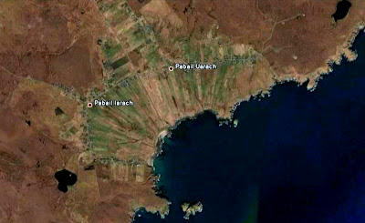
I read somewhere recently that Google Earth is of great assistance to archaeologists researching sites in parts of Afghanistan which are off-limits due to the sway of the Taliban. Well the same is equally true of the Eye Peninsula on the east coast of the island of Lewis in the Outer Hebrides (off limits - on a Sunday, anyway - due to the sway of the Free Church of Scotland!).
Note how on the following extract from GE in the village of Pabail, on the south east coast of the Eye Peninsula, you can see the footprints of various buildings I've labelled A, B, C, D & E
And note how you can see the same buildings on the 1849 Ordnance Survey 6 inch (1:10,560) map:-
A village cleared during the Highland Clearances? I don't think so because, if you pull back the scale a bit, you can see the village of Pabail still existing close by: it's unlikely the occupants of these ruins would have been "cleared" to a location so close by:-
One theory - and this is just pure amateur educated guesswork - is that these ruins are the remains of parts of the old run-rig village of Pabail before it was re-arranged into lots (crofts) on the pattern shown on the 1849 map during the kelp boom of the early 19th century.
I accept, incidentally, that the distinction between "re-arrangement" and "clearance" of a village is a fine one except to note that a number of "re-arranged" villages were later "cleared" in the decades after the end of the kelp boom at the end of the Napoleonic Wars (1815).
Pabail, however, survives to the present day in roughly the same pattern as in the 1840s as can be seen from the present day OS 1:25,000 map (courtesy of Streetmap.co.uk, the best place to view the OS 25k map) and GE which both show the crofting layout well:-
And this is what it looks like courtesy of Google Street View:-
And in the picture below, the ruins are half way to the houses on the skyline (which is the "suburb" of Pabail called Eagleton which didn't exist in 1849):-
And finally a word about the Gaelic rendering of the name of the village. It has two parts and on my unreconstructed 1960 OS one inch map, they are labelled Upper and Lower Bayble. As you can see on the 1849 OS map, these are rendered respectively Pabaill Ard and Pabaill Iosal but on the modern 1:25k map they've become Pabail Uarach and Pabaill Iarach. Now I'm no Gaelic scholar but I'm aware that ard and uarach both mean something like "high" or "upper" whereas iosal and iarach both mean something like "low" or "lower". But why the change over 150 years?
I can't help suspecting the OS went to their in-house Gaelic speaker and asked "What's the Gaelic for "upper"?" and he/she answered uarach. And thus the subtle nuance which led to the upper part of Pabail being named Pabail Ard (as recorded in 1849) rather than Uarach is at risk of being lost to history. Ditto Pabal Iosal/Iarach.
I gather that whether you spell it Pabail, Pabaill or Bayble is pretty academic because it's not a Gaelic name anyway but a Norwegian one meaning "Priest's Village". Of equal interest (to me) is how a place in this Norse-Celtic milieu came to be given the very English name of Eagleton. There must be a story behind that to be discovered - although I note that someone at the Comhairle with more sense of political correctness than history has transliterated it into Baile na h'Iolaire. Tsk!


A mixture of Old Norse (ON), & Gaelic place names coupled with an 18th Century English Speaking Naval Surveyor has lead to many a cock up on moden charts and maps. Witness "Chicken Head" west of Bayble and East of Stornoway.
ReplyDeleteNow on that Headland or Point are the remains of an old church. Thus in O.N. Kirk (church) Nes (Point)
Along comesour English Speaking surveyor (with no gaelic) and a local Rubhach with no English.
O.N. Kirk is translated as Cearc (gaelic) and a Cearc is a hen or chicken.
Thus we get Kirk- Cearc- Chicken and to this day "Chicken Head" nothing to do with chickens but everything to do with an old Church. Confused?