Wednesday, August 17, 2022

The A87 #5 - Kinloch Hourn

It's never been on the A87, of course, but it would be rude to pass through Tomdoun (which used to be on the A87) without nipping along to Kinloch Hourn for a quick look.

approaching Kinloch Hourn - Google Streetview

The whole 31 miles from Invergarry to Kinloch Hourn was one of the first roads built by the Highland Roads & Bridges Commission, on their usual basis of 50% state funding and 50% by local landowners, between 1805-12. The population of Glen Garry is sparse enough as far as Loch Quoich but after that, there's nothing (Glenquoich Lodge having been flooded by the Hydro Board in the mid-1950s as described in this post) until you get to Kinloch Hourn itself and it's just another lodge, a farm and a few estate workers' cottages - you can go for a virtual walk round here. So why did the HRBC build a road to nowhere? Have a look at the map below:-
 

A key plank of the HRBC's strategy was to encourage the herring fishing industry by linking the Great Glen and the east coast road network north of Inverness with what were described in the 1803 report by the engineer Thomas Telford on the industrial opportunities of the north west Highlands that led to the creation of the HRBC (see here) as "the lochs at the back of Skye" - that is Lochs Torridon, Carron, Alsh, Duich, Hourn and Nevis - where the herring were most plentiful. Hence why it built the roads coloured red on the map and this led to the creation (or expansion) of fishing villages like Shieldaig, Jeantown (called Lochcarron today), Plockton, Dornie & Bundalloch and Arisaig.

Fishing boats on Loch Hourn in 1815 by William Daniell

But why, considering Loch Hourn was one of the most prolific herring fisheries, did nothing happen at Kinloch Hourn? Well, this is just an educated guess but I think it's because the terminus of the HRBC's road at the head of the loch was too far inland - it was just too far from the fishing grounds for the fishermen to sail home to and land their catches when there were more conveniently sited spots like Shieldaig and Plockton etc. It's perhaps significant in this respect that the fishing village which did emerge on Loch Hourn - Arnisdale (which is strictly two neighbouring villages called Camusbane and Corran) - is on the outer part of the loch. HRBC plans to establish "boating piers" at Kinloch Hourn came to nothing.
 
Arnisdale with Corran top left and Camusbane bottom right. This is the part of Loch Hourn in the Daniell print above - photo credit: StephenH16
 
The HRBC's original proposal had been to continue the road past Kinloch Hourn along the north shore of the loch to Kyle Rhea which, at that time, was the principal crossing to Skye rather than Kyle Akin. But that was soon abandoned in favour of another route to Kyle Rhea from Invermoriston via Cluanie, Glen Shiel, Shiel Bridge (today's A87) and the Mam Ratagan plus a link to the Glen Garry road between Cluanie and Tomdoun. That's because these were the routes preferred by cattle drovers. Seven years later, in 1812, with the road from Invermoriston via Glen Shiel having reached only as far as Ceannacroc in Glen Moriston and further progress west held up by wrangling over costs, the new owner of Glenelg Estate, Patrick Bruce, revived the plan of reaching Kyle Rhea from Kinloch Hourn (albeit by an inland route rather than along the north shore of Loch Hourn). This intervention allowed the HRBC the opportunity to give the backers of its preferred option, the Glen Shiel route, an ultimatim: deposit their 50% share of its cost by 1st June 1812 or else it would reluctantly fund the Bruce route instead. This did the trick - the Glen Shiel road with its Cluanie-Tomdoun link was built and Kinloch Hourn was destined to remain forever a dead-end. 
 
Kinloch Hourn as depicted on an 1857 Admiralty Chart - photo credit: National Libraries of Scotland

All this meant that the 16 miles from Tomdoun to Kinloch Hourn must count as the least successful road, by some margin, the HRBC ever built - most of the rest of them remain integral parts of the road network to this day. It's a pity because the road to Kinloch Hourn was also one of their most challenging from the engineering perspective. This led to it being completed six years behind schedule and it was literally the death of the contractor, Mr Dick from Perth - he was killed by "falling down a precipice" on his way from Loch Hourn to Arisaig where he and his partner, Mr Readdie, were also building the HRBC road from Fort William. Dick's nephews took over the contract and managed it well enough: the Commission's consulting engineer Thomas Telford remarked somewhat sniffily that their bridges "though somewhat rudely are all strongly built".  
 
a tight corner near Kinloch Hourn
 
In the 1930s, there were proposals to build a power station at Kinloch Hourn powered by water sent down through a tunnel from a dammed and enlarged Loch Quoich: the short steep drop from the loch to the sea (about 650 feet in less than 3 miles) is a hydro-electric engineer's dream if a road engineer's nightmare. But the proposal was defeated in parliament and when the waters of Loch Quoich were harnessed by the Hydro Board in the 1950s, it was on the basis of the water being sent eastwards to the turbines (more about all that in this post). Thus was the seal set on Kinloch Hourn as the remotest of scenic backwaters, frequented only by hillwalkers and deer stalkers and untouched by the industry Thomas Telford had hoped for it 200 years ago.
 
Kinloch Hourn looking east (inland) in 1987

Sunday, August 14, 2022

The A87 #4 - the Tomdoun Hotel

Tomdoun Hotel in the 1950s - photo credit: daves_archive1


At the end of episode 3, we'd arrived at the Tomdoun Hotel ten miles up Glen Garry from the beginning of the A87 at Invergarry. 

Sadly, it's no longer a hotel, though, as it ceased trading at the end of 2011. It was placed on the market but didn't sell as a going concern and was eventually sold in December 2014 (for £235k) for conversion to a house. 

I've long been fascinated by the Tomdoun Hotel - a wayside hostelry one would have thought cast into oblivion by the trunk road which ran past its front door having been re-routed so dramatically (see map in episode 3). I made a point of going to stay at Tomdoun (a reminder that it's pronounced "Tom-DOWN") in the late 1980s and I'm glad I did now that I can't anymore. It was everything I'd imagined it would be - a classic stags' heads and stuffed fish mounted on the wall, dark polished wood, log fire and malt whisky after dinner sort of place: for Python afficionados, it was about as woody as it comes. Regrettably, I didn't have the wit to take any internal pictures but fortunately other people had the presence of mind to do that before the hotel closed. Here's a selection:-

photo credit: DJMS Photos

photo credit: qrtzcntrl

photo credit: Qrtzcntrl

photo credit: Andy Jaffray

photo credit: pete "lilo lil" varley

photo credit: Chris Firth

The hotel was built in 1895, one of the many public buildings erected under the auspices of the Ellice family who owned Glengarry Estate in the late 19th century (most of them in Invergarry village as described in this post). So it's not very old but it is relatively unusual amongst Victorian country house hotels in not having been spoilt by 1950s/60s extensions (like the Balmacara Hotel for example): the Tomdoun Hotel looks almost exactly the same today as the day it was completed. 

The 1895 hotel replaced an earlier inn which stood 200 metres west at the junction of the Kinloch Hourn and Cluanie roads: it was probably built around the same time as these roads were (c.1810-20). You can see the old inn on the 1872 OS 6 inch map below. The 1895 hotel stands at about the "ow" of "Tomdown".

OS 6 inch map, 1872

The old inn and "new" hotel stood side by side for a time as you can see on the second edition of the 6 inch map surveyed in 1899 here but it's gone now. I don't know when it was demolished. 

I've not been able to find a picture of the old inn and would kill to see one ... but wait a minute, what's that in a photo on the wall in one of the internal pictures of the hotel above?


Could that be the old inn? [EDIT 24/6/24 - It is. You can see the photo here.]

If not a confirmed photo, there does exist a brief account of a visit to the old inn. It's written by the pseudonymous "Nauticus on his Hobby-Horse" who made a tour of Scotland on a Cheylesmore tricycle in 1881:-

I found Invergarry Inn half a mile farther along the north bank [of the River Garry from the old bridge over the river: this too would be the old inn at Invergarry before the present hotel was built in 1885]. I had tea with an elderly gentleman, who appeared to go in for enjoying life, hunting all the winter and fishing all the summer. From him I gained the following information:- (1) Glengarry caps are named from this glen; (2) The Garry Falls should on no account be missed; (3) Tomdoun Inn is a good one, and situated in the finest valley in Scotland; (4) The roads on the west coast would be too hilly for my tricycle.

7.30 [pm]. All the inhabitants turned out to see me start, a tricycle never having been seen here before. [After describing a stop at the Garry Falls, Nauticus resumes at the west end of Loch Garry] The road, which from Spean Bridge had consisted of hard sand, now became soft, and covered with fresh metal [gravel]. Hereabouts I began to look out for the "finest valley in Scotland" but bleaker and bleaker became the way, until Tomdoun, a solitary inn, was reached at 9.30. It was being enlarged [this isn't referring to building the new hotel which wasn't till twelve years later], which was unfortunate, but as I was the only lodger I managed pretty well. While they were preparing my meal I took a survey of this wild place among the hills, and while watching the national game of "Throwing the Hammer" I felt that I was really in the Highlands.

[Next morning] Although I had arrived late, I decided to make an early start in the morning. I was called at seven; but as the festive rat had kept me awake the best part of the night, I gladly availed myself of the excuse that it was raining to turn over on the other side and "drive my pigs to market" again."

I don't know what the reference to the "festive rat" means. Did he literally mean he was kept awake by rats scurrying about or is it another metaphor like "driving your pigs to market" (snoring - which I didn't know)?

Advert in Inverness Courier, 7 February 1896 - British Newspaper Archive
 
Nauticus the tricyclist's host at the Tomdoun Inn was Peter Grant who would have rented it from the Ellices of Glengarry Estate. The estate built the new hotel (for £7,000 - about £650k in today's money) and advertised for a new tenant for it (see above) but Peter Grant seems to have secured the lease anyway. He died not long after and was followed in the tenancy of the hotel by his son, another Peter, who had it until his death in 1940. Thereafter it was managed by Peter the younger's daughter until, I believe, the 1960s - three generations over about 80-90 years is quite an achievement.

During the earlier part of the 20th century, the "new" hotel appears to have been more like a sort of hunting lodge open to the public than a typical wayside inn or hotel. Only open during the fishing and stag stalking seasons, J M Barrie was a regular visitor with the Llewelyn Davies brothers who were his wards after their parents died and the inspiration for the characters of Peter Pan. I found the following quotes in a biography of one of the brothers:-

"[The Tomdoun Hotel was] both a family home and provided accommodation for the staff that worked on the farm the Grants owned. It also housed the telegraph office. There were four or five 'suites' to let, guests had a bedroom and adjoining sitting room and shared a bathroom/WC. Meals were provided, either in the private rooms or in the dining room. You took what was offered. There was no bar but drinks could be taken in the drawing room."

and

"[The menu consisted of] mutton broth, trout and then mutton, which one could seldom masticate with any ease. So far as a bath was concerned, and you were fortunate enough to get there first, you might manage to find a trickle of tepid water and God help those who followed. The bedrooms were always spotlessly clean but had the oldest iron bedsteads and the mattresses so hard that [it was] only through real tiredness after a hard day's fishing that sleep came one's way."

It doesn't sound a great improvement over what Nauticus the tricyclist had to put up with in the old inn!

Fishing the Tomdoun water - photo credit: Cap'n Fishy
Trout fishing rather than salmon was the speciality on the Tomdoun Hotel's five miles of private fishing on the River Garry. For eight years (1957-65) it held the record for the biggest brown trout caught in Britain at 17lbs 8oz. It was preserved in a glass case in the hotel and its record was broken by an 18lbs 2oz fish caught just downstream on Loch Garry. (The current record is 30lbs 8oz caught on Loch Awe.)

Tomdoun in December 2019 - photo credit: Allan Maciver

So, closed since 2011, what of the Tomdoun Hotel today? Well it's back as an even more upmarket hunting lodge. Owned together with the neighbouring 9,800 acre East Glenquoich Estate since 2019 by Richard Tuxford, it's been rebranded Tomdoun House and Estate and is available to rent for huntin', fishin' & shootin' parties - there's no tariff on the estate's website so I guess if you need to ask, you can't afford it! As you can see from the photo above, externally there's no change but internally it's had quite the makeover:

Tomdoun in the 2020s - photo credit: Tomdoun Estate

More pictures here. No sign of that photo of the old inn. Or the record trout. I wonder what became of them?

Monday, July 25, 2022

The A87 #3 - Glen Garry

We finished episode 2 of the A87 - the road from Invergarry on the Great Glen to Uig on Skye via Kyle of Lochalsh (map here and click to redirect) - 5 miles west of Invergarry at the junction with the road to Kinloch Hourn. 

The main road straight on from this junction is, in fact, a big diversion of the A87's original route as laid out by the Highland Roads & Bridges Commission in the early 19th century caused by hydro electric developments in the 1950s. Look at the map below (click to enlarge):-


Today, the A87 follows the orange line on the map from Glen Garry over to Bunloyne in Glen Moriston where it joins the A887 from Invermoriston on Loch Ness. But it used to run up Glen Garry as far as Tomdoun (pronounced "Tom-DOWN") where it branched off the road to Kinloch Hourn and went north over the hills to Glen Loyne and then over the next ridge of hills to join the A887 at Cluanie. 

The Moriston Hydro Electric scheme built in the mid-1950s involved building a dam in Glen Loyne to create a reservoir - Loch Loyne - which would flood the A87 as it passed through the glen. The original proposal was for a viaduct over the new reservoir but that was discarded in favour of a new road along its south shore (broken orange line on the map). On the plus side, that would not only be cheaper than the viaduct but also create a route with shallower gradients and a lower summit than the road over to Cluanie (about 800 feet instead of 1,400) making it less liable to closure by snow in winter. But the downside was that it added six miles to the journey from Invergarry to Cluanie so that proposal was in turn discarded in favour of the solid orange line on the map which was only one extra mile. This was actually much more expensive than the original viaduct proposal but the Government picked up the extra cost from the Hydro-Board because it (the Government) would be relieved of the cost of eventually having to upgrade the Tomdoun to Cluanie road (a single track) which, because nobody lives between these two points, could be abandoned. Thus, as well as possessing some of the country's premier ghost junctions (see previous post), the A87 includes an entire ghost road! 
 
The old road disappearing into Loch Loyne approaching from the south. Note the track of the road climbing the hill towards Cluanie on the other side.

For the purposes of this tour along the A87, I'm going to start with the old road up Glen Garry to Tomdoun and over the hills by the ghost road to Cluanie. Then, in subsequent post(s), we'll come back and follow the present road (orange on the map) via Bunloyne and along the north side of Loch Cluanie.

So, starting in Glen Garry, the caption and message on the back of the J Arthur Dixon postcard below, posted at Tomdoun in 1967, sum the glen up quite well:-

As the caption says, Loch Garry is a hydro-electric reservoir although the natural level of the loch was raised (by a dam at its west end) by only 12 feet which is small compared with some hydro-reservoirs. However, as the road ran very close to the shore of the loch, a lot of it had to be re-routed along a slightly higher line. The postcard shows the old road perilously close to being overlapped by the raised loch. Below, 700 yards past Ardochy House, you can see the raised line of the road diverging from the original line:-

Google Streetview

And aerial photography shows the original line of the road along the edge of the loch. At the left, you can even see it under the water:-

National Libraries of Scotland

The National Libraries of Scotland's excellent Georeferenced Map Viewer is great for viewing hydro-electric developments because it allows you to overlay old (pre-hydro) maps over modern aerial imagery. Select Bing Satellite as the background from the drop down menu at the top, then choose a map series to overlay from the dialogue at bottom left (if necessary, open this from the "Choose map layers" link at bottom left). Then use the "Change transparency of overlay" slider at the bottom of that dialogue to reveal the modern aerial photography under the map.

The pre- and post-hydro water levels at the west end of Loch Garry

The writer of the postcard was a bit out with her timing when she said (in 1967) that the road along Loch Garry was a main road to the Isles "until about 4 years ago", though. The Garry Hydro-Electric Scheme (which also included damming and raising Loch Quoich further up the glen beyond Tomdoun as described here) was built between 1950 and 1956 so "about 10 years ago" would be nearer the mark.
 
The postcard view below is at the west end of Loch Garry looking east. It was taken in the 1930s before the loch was raised and this section of the road was flooded and moved to a higher line (to the left).
 
You can see the abutments of the bridge in the middle of the postcard above (click it to enlarge) under the water on aerial imagery:-
 

Although the hydro scheme didn't raise Loch Garry very much compared with other hydro reservoirs (only 12 feet), it did increase its surface area quite a lot by flooding about 2 miles of low lying flood plain of the River Garry at the loch's west end. The picture below (looking west from the "new" A87 over to Bunloyne) shows the reservoir drained down to almost the loch's natural level. The two levels of road are clearly visible:

Loch Garry drained down to almost its natural level: photo credit Peter Jeffrey
 
Away from 20th century hydro-electric developments now, on the south side of Loch Garry at its west end is a farm called Greenfield. In 1803, James Hogg (the poet known as the Ettrick Shepherd) stayed here in a late surviving example of a "creel house". That is a house the walls of which were made of blocks of turf (peat, essentially) rather than stone. The inside of the walls was lined with wattle basketwork ("creel") which was plastered. Creel houses were once very common but due to the perishable nature of their building materials compared with stone, none have survived although the National Trust for Scotland has recently built a replica at Glen Coe. 
 
Replica creel house under construction in Glen Coe with the internal wattle ("creel") lining and turf blocks of the outer walls clearly visible. Photo credit National Trust for Scotland
 
That gentry lived in creel houses as much as ordinary folk obviously took Hogg a little by surprise:-
 
On reaching Glengarry, the first place we came to was Greenfield, possessed by Mr. M'Donald. The house was really a curiosity. It was built of earth, and the walls were all covered with a fine verdure, but on calling we were conducted into a cleanly and neat-looking room, having a chimney, and the walls being plastered. The ladies, Mrs. M'Donald and her sister, were handsome and genteelly dressed, although unapprised of our arrival, unless by second sight. They were very easy and agreeable in the manners, and very unlike the outside of their habitation. 
 
In leaving the MacDonalds of Greenfield's creel house after a late dinner (at which "plenty of punch" was drunk) and crossing the glen to Inchlaggan Farm and taking up lodging with its tenant, Thomas Gillespie, at his shepherd's cottage, Hogg was moving from one world to another. A native of Moffat in the Borders, Gillespie was one of the earliest sheep farmers in the north west Highlands, having come north to rent sheep grazing in Glen Garry in 1782 when he was just 22 years old. It was a condition of the deal that the existing population was cleared off first and the same pattern was repeated as Gillespie increased his holdings on Glengarry and neighbouring estates to become one of the greatest sheep farmers in the Highlands. Hogg was aware of the social dislocation being caused - the Clearances, we call it now - and was uneasy about it but it didn't stop him waxing lyrical about the benefits he expected the expansion of sheep farming to bring. It's an interesting insight into how the enormity of these slow burning disasters often doesn't become fully apparent until long after the event. (You can read Hogg's account of his trip to the Highlands here.)

A mile past Inchlaggan and we're at Tomdoun where the old A87 branched off to the right (north) to cross the hills to Cluanie - that's a convenient place to break until the next instalment.

The west end of Loch Garry as surveyed in the early 1950s before commencement of the hydro works. OS One Inch map, Sheet 36 from National Libraries of Scotland

Wednesday, July 20, 2022

By stress of weather: the loss of the Nelly

I'm conscious it's almost a year since I've posted on here but I'm breaking silence to report that I've bought a subscription to The British Newspaper Archive. 

And boy, is it worth it! For the last few days I've been addicted: I'm like a kid in a sweetie shop peppering it with search terms of interest and coming up with far more gems of results than I'd imagined. I'll need to rationalise my researches somewhat once the novelty has worn off but in the meantime I wanted to share the news story I've found so far that's grabbed me the most. It's from the Caledonian Mercury of 6 October 1779:-


What a story is concealed in these six meagre lines! Let's try and flesh it out a bit with a bit of intelligent speculation.

The Nelly (even the name lends an air of tragedy!) was a sailing ship of - I'm guessing - about 80-90 feet in length and two masts with her home port at Newcastle-upon-Tyne. I suspect she probably looked quite like this:-

Picture credit: Wooden ships

In September 1779, she set out from Lochmaddy in North Uist in the Outer Hebrides to sail east round the north of Scotland to Whitby in Yorkshire. On 16 September, "by stress of weather" (i.e. in a storm) she was wrecked on an island called Eynhallow (as it's now usually spelt) in Orkney. All on board perished except a single seaman.


Eynhallow is a small island (about a quarter of a square mile) in Eynhallow Sound between the mainland of Orkney and the neighbouring island of Rousay.

It looks as though the Nelly was attempting to traverse Orkney through Eynhallow Sound rather than by the normal route through the Pentland Firth between Orkney and the mainland of Scotland. Both routes are plagued by ferocious tidal streams adding to the complexities of navigating an unwieldy 18th century sailing ship. In Eynhallow Sound, the tide races - or rosts (pronounced "roosts") as they're called in Orkney and Shetland dialect - on either side of the island even have names: the Burgar Rost and the Wael Rost. The passage to the north of Eynhallow is also studded with reefs and skerries so it's a navigational death trap: a modern yachtsman recommends (here) the south passage and keeping the yacht's engine running in case needed to get out of trouble, not a luxury available to Captain Nathaniel Brown of the Nelly. Fifty years later, he could have avoided the perils of Orkney waters by using the Caledonian Canal.

The hazards of Eynhallow Sound as seen on a mid-19th century Admiralty Chart - National Library of Scotland


The only survivor from the wreck of the Nelly was a seaman who got ashore by clinging to the ship's separated foremast. Though deserted today, Eynhallow would have had a population of a few dozen in the 18th century. They presumably assisted in rescuing the survivor and sheltered him before taking him over to the mainland of Orkney once the storm had subsided. 

It's interesting to note that the letter informing of the Nelly's loss (addressed to her owners in Newcastle, I assume), dated at Stromness (on the mainland of Orkney) on 24th September, was known about in Edinburgh in time to be published in the Caledonian Mercury on 6th October, only twelve days later. That seems quite a short time to me for the 18th century - was the letter conveyed by ship all the way from Orkney or by post runner overland? (No mail coaches in these days, I think, at least not in the north of Scotland - no roads for them to run on.)

Eynhallow from Mainland with Rousay behind: picture credit Tim Martin

Interesting as well that the Nelly's cargo from Lochmaddy was kelp. I've written about his before (here) but, briefly, kelp was a crystalline material produced by burning seaweed. It was used in the soap and glass making industries until the chemicals kelp contained became more cheaply available from other sources in the second quarter of the 19th century. The seaweed was gathered on the west coast of Scotland (and Orkney) and burnt in pits on the shore to produce kelp: North Uist was prime kelping territory. The industry boomed c.1775-1825 providing employment for islanders and huge wealth for the landowners along whose coasts the seaweed grew until its collapse gave rise to poverty leading to emigration in some of the grimmest episodes of the Highland Clearances while bankrupt landlords were forced to sell their estates. (The owner of North Uist, Lord Macdonald, built Armadale Castle on the profits of kelp then had to sell the island in the 1850s.)

Eynhallow Sound from the west. Eynhallow is the low lying land with no snow, Rousay with the snow. Picture credit: January Joe

And finally, what of the other three characters apart from the surviving seaman - Captain Brown and the two lady passengers? I have a mental image of someone like Ioan Gruffud or the Poldark bloke, all tricorn hat and reefer jacket. Did he die heroically trying to save the ladies? Or was he a scoundrel who's first instinct on realising the ship was lost was to rifle their luggage for valuables while he shouted at them to silence their screams of terror as the Nelly pounded itself to splinters on the rocks of Eynhallow? 

And who were these ladies and why were they going to Whitby? It's a reasonable guess they were "quality", perhaps the daughters of a tacksman (Scottish word for gentleman tenant farmer). And maybe they were actually going to London or Bath or somewhere for the season but Whitby was the nearest to there any ship from Lochmaddy was likely to be sailing to. The fact they're not named suggests the surviving seaman didn't know who they were but did he have the wit to suggest another letter be sent from Stromness to Lord Macdonald's chamberlain on North Uist informing of their demise? We shall never know but the speculation this briefest of notices in the Caledonian Mercury in 1779 provokes almost makes the subscription to the British Newspaper Archive worth it by itself!

The Loss of a Merchantman by Francis Hustwick. Picture credit: Ferens Art Gallery via ArtUK


Wednesday, August 4, 2021

The A87 #2 - Invergarry ghost junction and the Faichem loop

Last year, I wrote a post (here) about what I call ghost junctions - major road junctions that have moved due to realignment of the roads concerned but where the original junction - the ghost - remains, either as a local junction between minor roads or just a faintly discernable footprint. For some reason, I forgot to mention in that post a particularly fine ghost junction - the one at Invergarry between the A82 and the A87 to Kyle of Lochalsh and Uig on Skye. But this, the second post in the series on the A87 (map in the first post), is the perfect place to remedy that omission.

Note first that, with all pictures in this and subsequent posts like the one below with a Google Streetview link under it, if you click the link it will take you to the position in GSV so you can have a virtual look round.  

Invergarry A82/A87 junction - Google Streetview

Pictured above is the present day junction viewed from the south and the bridge over the River Garry with the A87 going off to the left. But this only dates back to 1932 and before that the junction was at an older bridge 600 yards downstream (to the right/east). On the map below (click it to enlarge), the red line is the original approach from the south to the old bridge and junction and the blue line the current:-

Ordnance Survey 25 inch map, 1899

The old road and bridge still exist and are driveable and, fortunately for armchair ghost junction enthusiasts, the Google Streetview car has been along them. Approaching from the south, the old road leaves the present road just before the new bridge here - yes, you can turn onto that track on the right there! Continuing east, you'll end up at the old bridge over the Garry and the old junction on its far side.

Old junction at Invergarry - Google Streetview

The road building history around here is that the first of General Wade's military roads was the one up the Great Glen from Fort William to Inverness built in 1725-27. It passed along the opposite (east) side of Loch Oich but a more general criticism of the Wade roads towards the end of the 18th century was that

"having been laid out with other views than promoting commerce and industry, are generally in such directions, and so inconveniently steep, as to be nearly unfit for the purposes of civil life; and in those parts where they are tolerably accessible ... the use of them is very much circumscribed from the want of bridges over some of the principal rivers."

Thus was born in 1803 the Highland Roads & Bridges Commission (HRBC). Set up by an Act of Parliament and under the engineering superintendence of Thomas Telford (most famous for the Menai Suspension Bridge and author of the words just quoted), the HRBC provided half of the costs of approved road and bridge building schemes, the other half to be met by the local landowners.

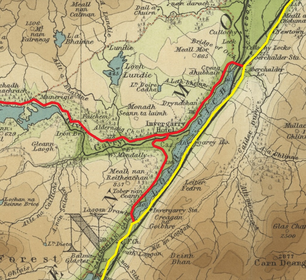
One of the earliest Parliamentary Roads (as they became known) was one down the west side of Loch Oich, with a bridge across the River Garry and linking with the military road on the east side of the loch at each end, and then, branching off from this, a road west up Glen Garry, along the north bank of the river and all the way to the west coast at Kinloch Hourn. Thus was built the old bridge and junction at Invergarry in about 1805-06.

Military road (1725-27) in yellow, Parliamentary (Highland Roads & Bridges Commission) road (1805-06) in red. Bartholomew's half inch map 1902-06 via National Libraries of Scotland

Invergarry Old Bridge (1805-06) viewed from downstream (the east)

Part of the HRBC's work had been to upgrade the road network from one designed in the pre-industrial era for the movement of troops to one adapted to the needs of commerce during the onset of the industrial revolution. 120 years later, there was another imperative - to adapt the road network to the needs of motor traffic. Hence in the 1920s, there began two major road improvement schemes in the Highlands, the A9 from Perth to Inverness in 1924-28 and the A82 from Tyndrum to Inverness via the Glen Coe and the Great Glen in 1931-33 (contemporary news article about that here). The latter scheme included the construction of a new concrete bridge at Invergarry and the re-arrangement of the A82/A87 junction in 1932.

The present bridge (1932) and A82/A87 junction looking south

So, turning on to the A87 at last, the sign beside the road tells us it's 50 miles to Kyle of Lochalsh:-
 
Invergarry - Google Streetview

Note that the 1930s fingerpost at the top of this post indicates 52 3/4 miles to Kyle. So for all the diversons and re-routing the A87 has undergone over the years, it seems to be only 2 3/4 miles shorter between here and Kyle. You find the first such diversion only 200 yards beyond the far (west) end of Invergarry, less than a mile from the junction, at a sign pointing right to Faichem:-

Faichem junction - Google Streetview

This is a loop of the old single track road left when the A87 between Invergarry and Kinloch Hourn junction (4 miles) was doubled in the mid/late 1960s - I don't know the exact date except the new road is marked on the OS 1:2,500 map surveyed in 1967. Anyway, the Faichem loop rejoins the new road about a mile further on and the Google Streetview (GSV) car has been along it so go and have a look - you don't miss anything on the main ("new") road.

400 yards on from where the Faichem loop rejoins the main road, another stretch of the old road opens on the left (here). It's not a loop but remains as an access to Loch Garry Dam. The GSV car has been part of the way along. As there's a timber yard and sawmill down here as well, the traffic along this stretch of old road is heavier than on the Faichem loop so it gives a better idea of how this bit of the A87 may have looked when it was till a single track road in the early 1960s.

The Ordnance Survey One Inch Map, 7th ed. drawn before this part of the A87 was doubled. The current line of the road is in orange leaving the Faichem loop (A to B) and the branch of the old road to Loch Garry Dam and timber yard (C to D). 

Half a mile further on we're beside Loch Garry and there are loops of the old road left as lay-bys when the road was doubled in the mid/late 1960s.
 
Beside Loch Garry - Google Streetview

Below is approximately the same spot in the 1930s:-

After another two miles, we reach a junction on the left sign-posted for Tomdoun and Kinloch Hourn and that's a good point at which to break until the next episode of the A87.

Kinlochourn junction - Google Streetview