We finished episode 2 of the A87 - the road from Invergarry on the Great Glen to Uig on Skye via Kyle of Lochalsh (map here and click to redirect) - 5 miles west of Invergarry at the junction with the road to Kinloch Hourn.
The main road straight on from this junction is, in fact, a big diversion of the A87's original route as laid out by the Highland Roads & Bridges Commission in the early 19th century caused by hydro electric developments in the 1950s. Look at the map below (click to enlarge):-
Today, the A87 follows the orange line on the map from Glen Garry over to Bunloyne in Glen Moriston where it joins the A887 from Invermoriston on Loch Ness. But it used to run up Glen Garry as far as Tomdoun (pronounced "Tom-DOWN") where it branched off the road to Kinloch Hourn and went north over the hills to Glen Loyne and then over the next ridge of hills to join the A887 at Cluanie.
The Moriston Hydro Electric scheme built in the mid-1950s involved building a dam in Glen Loyne to create a reservoir - Loch Loyne - which would flood the A87 as it passed through the glen. The original proposal was for a viaduct over the new reservoir but that was discarded in favour of a new road along its south shore (broken orange line on the map). On the plus side, that would not only be cheaper than the viaduct but also create a route with shallower gradients and a lower summit than the road over to Cluanie (about 800 feet instead of 1,400) making it less liable to closure by snow in winter. But the downside was that it added six miles to the journey from Invergarry to Cluanie so that proposal was in turn discarded in favour of the solid orange line on the map which was only one extra mile. This was actually much more expensive than the original viaduct proposal but the Government picked up the extra cost from the Hydro-Board because it (the Government) would be relieved of the cost of eventually having to upgrade the Tomdoun to Cluanie road (a single track) which, because nobody lives between these two points, could be abandoned. Thus, as well as possessing some of the country's premier ghost junctions (see
previous post), the A87 includes an entire ghost
road!
 |
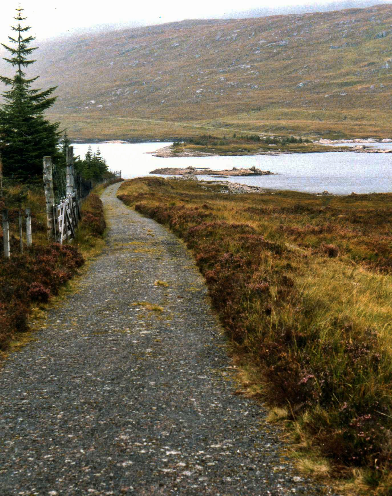
The old road disappearing into Loch Loyne approaching from the south. Note the track of the road climbing the hill towards Cluanie on the other side.
|
For the purposes of this tour along the A87, I'm going to start with the old road up Glen Garry to Tomdoun and over the hills by the ghost road to Cluanie. Then, in subsequent post(s), we'll come back and follow the present road (orange on the map) via Bunloyne and along the north side of Loch Cluanie.
So, starting in Glen Garry, the caption and message on the back of the J Arthur Dixon postcard below, posted at Tomdoun in 1967, sum the glen up quite well:-
As the caption says, Loch Garry is a hydro-electric reservoir although the natural level of the loch was raised (by a dam at its west end) by only 12 feet which is small compared with some hydro-reservoirs. However, as the road ran very close to the shore of the loch, a lot of it had to be re-routed along a slightly higher line. The postcard shows the old road perilously close to being overlapped by the raised loch. Below, 700 yards past Ardochy House, you can see the raised line of the road diverging from the original line:-
And aerial photography shows the original line of the road along the edge of the loch. At the left, you can even see it under the water:-
The National Libraries of Scotland's excellent Georeferenced Map Viewer is great for viewing hydro-electric developments because it allows you to overlay old (pre-hydro) maps over modern aerial imagery. Select Bing Satellite as the background from the drop down menu at the top, then choose a map series to overlay from the dialogue at bottom left (if necessary, open this from the "Choose map layers" link at bottom left). Then use the "Change transparency of overlay" slider at the bottom of that dialogue to reveal the modern aerial photography under the map.
 |
The pre- and post-hydro water levels at the west end of Loch Garry
|
The writer of the postcard was a bit out with her timing when she said (in 1967) that the road along Loch Garry was a main road to the Isles "until about 4 years ago", though. The Garry Hydro-Electric Scheme (which also included damming and raising Loch Quoich further up the glen beyond Tomdoun as described
here) was built between 1950 and 1956 so "about
10 years ago" would be nearer the mark.
The postcard view below is at the west end of Loch Garry looking east. It was taken in the 1930s before the loch was raised and this section of
the road was flooded and moved to a higher line (to the left).
You can see the abutments of the bridge in the middle of the postcard above (click it to enlarge) under the water on aerial imagery:-
Although the hydro scheme didn't raise Loch Garry very much compared with other hydro reservoirs (only 12 feet), it did increase its surface area quite a lot by flooding about 2 miles of low lying flood plain of the River Garry at the loch's west end. The picture below (looking west from the "new" A87 over to Bunloyne) shows the reservoir drained down to almost the loch's natural level. The two levels of road are clearly visible:
.jpg) |
Loch Garry drained down to almost its natural level: photo credit Peter Jeffrey
|
Away from 20th century hydro-electric developments now, on the south side of Loch Garry at its west end is a farm called Greenfield. In 1803, James Hogg (the poet known as the Ettrick Shepherd) stayed here in a late surviving example of a "creel house". That is a house the walls of which were made of blocks of turf (peat, essentially) rather than stone. The inside of the walls was lined with wattle basketwork ("creel") which was plastered. Creel houses were once very common but due to the perishable nature of their building materials compared with stone, none have survived although the National Trust for Scotland has recently built a replica at Glen Coe.
 |
Replica creel house under construction in Glen Coe with the internal wattle ("creel") lining and turf blocks of the outer walls clearly visible. Photo credit National Trust for Scotland
|
That gentry lived in creel houses as much as ordinary folk obviously took Hogg a little by surprise:-
On reaching Glengarry, the first place we came to was Greenfield, possessed by Mr. M'Donald. The house was really a curiosity. It was built of earth, and the walls were all covered with a fine verdure, but on calling we were conducted into a cleanly and neat-looking room, having a chimney, and the walls being plastered. The ladies, Mrs. M'Donald and her sister, were handsome and genteelly dressed, although unapprised of our arrival, unless by second sight. They were very easy and agreeable in the manners, and very unlike the outside of their habitation.
In
leaving the MacDonalds of Greenfield's creel house after a late dinner
(at which "plenty of punch" was drunk) and crossing the glen to Inchlaggan
Farm and taking up lodging with its tenant, Thomas Gillespie, at his
shepherd's cottage, Hogg was moving from one world to another. A native
of Moffat in the Borders, Gillespie was one of the earliest sheep
farmers in the north west Highlands, having come north to rent sheep
grazing in Glen Garry in 1782 when he was just 22 years old. It was a
condition of the deal that the existing population was cleared off first
and the same pattern was repeated as Gillespie increased his holdings
on Glengarry and neighbouring estates to become one of the greatest
sheep farmers in the Highlands. Hogg was aware of the social dislocation
being caused - the Clearances, we call it now - and was uneasy about it
but it didn't stop him waxing lyrical about the benefits he expected
the expansion of sheep farming to bring. It's an interesting insight
into how the enormity of these slow burning disasters often doesn't
become fully apparent until long after the event. (You can read Hogg's account of his trip to the Highlands
here.)
A
mile past Inchlaggan and we're at Tomdoun where the old A87 branched
off to the right (north) to cross the hills to Cluanie - that's a
convenient place to break until the next instalment.
 |
The west end of Loch Garry as surveyed in the early 1950s before commencement of the hydro works. OS One Inch map, Sheet 36 from National Libraries of Scotland
|


.jpg)


No comments:
Post a Comment