Monday, December 27, 2010

Fain Inn

A good five miles from the nearest habitation, a derelict house stands beside the A832 between Dundonnell and Braemore Junction in Wester Ross.

Photo Credit Wilde Tucker. The mountain in the background is An Teallach (pronounced "TCHALL-ach" - gaelic for "The Anvil"

This remote spot - which I drove past this afternoon - is called Fain. (It's from the gaelic word feithean meaning "boggy channels" which is apt because this is on the watershed where streamlets gather amongst the peat bogs to form the Dundonnell River.)


The empty house has something of a reputation as having once been a droving inn called the Fain Inn but I've always had my doubts about this. For a start, it doesn't look old enough to have been a droving inn (even allowing its present corrugated iron roof to have been a later addition). Also, it just doesn't look very "inn shaped", somehow. There's more pictures of the house here.

Photo credit Ben Allison

Anyway, the amazing wealth of information you can derive from the internet allows me confirm that there was an inn at Fain but this building isn't it. Here's the proof:-

First, Ordnance Survey 6 inch map surveyed in 1875


Note how the inn is marked to the north of the burn running in from the north east.

Next, the present day aerial view from Bing Maps:-


Note how the present day building is south of the burn.

The road from Dundonnell to Braemore is known as the Destitution Road because it was built in the 1840s to provide work for the local tenantry suffering from the potato famine. Before this, the main route east from Dundonnell was directly to Altnaharrie (still a hotel until recently) on the west shore of Loch Broom from where there was a ferry across the loch to Ullapool.

The original Fain Inn, of which no trace now survives, would have been established with the opening of the Destitution Road to Braemore in the 1840s. This was years after droving (taking herds of cattle south to market) had ceased but a Widow Mackinnon was noted as living at Fain in the 1861 census.

Photo credit Photospool

Although I didn't stop at the Fain Inn this afternoon, I did stop a couple of miles south and noted this brass plaque recording the upgrading of the Destitution Road from a single track to double track in the 1960s


Lots of history going on in the remotest of places!

Wednesday, October 27, 2010

The Porter's Lodge

Just before the end of the public road out to the Rhue of Arisaig there's a splendidly remote cottage which rejoices under the rather incongruous name "The Porter's Lodge".


As is so often the case with such names, there's an interesting story - this is it.

A few hundred yards past The Porter's Lodge, at the end of the public road, there's a stone shed with a slate roof looking out towards the islands of Rum and Eigg.


This was the goods shed for Arisaig Pier which used to stand here but has now completely crumbled away. Before the railway to Mallaig was built in 1901, Arisaig Pier was the port of call by steamers for the Arisaig - Morar area given that Mallaig and its harbour (like Kyle of Lochalsh) didn't exist before the railway.


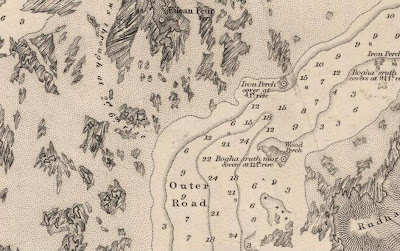
The pier was away out here, about 3-4 miles by road from Arisaig Inn at the end of the road from Fort William, because the loch the village sits at the head of - Loch nan Ceall - has a narrow, shallow and reef strewn entrance unsuitable for steamers to enter as the Google Earth image below shows ...


and the 1858 Admiralty Chart confirms:-


So the MacBrayne's steamers, Claymore (1881-1931) and Clansman (1870-1909), on their weekly trips from Glasgow - which were the main means of conveyance of passengers and goods to the remote parts of the West Highlands before road transport became prevalent in the 1930s - didn't go up the loch. Nor, even, did they come alongside the pier at its mouth because Arisaig was a ferry call - i.e. where the steamer lay off shore and a small launch (the ferry) went out from the shore to meet it.

The eponymous "porter", then, was the ferryman who had acquired his alternative job title because, amongst his duties, was lugging the trunks of passengers - very often gentry visiting the various "big houses" in the area during the season - in and out of the ferry. And the "lodge" was not just where the "porter" lived but also the waiting room for steamer passengers.

A ferry coming out to a ship I know, although you can't see it, to be the Claymore at an unidentified location

I'm obliged to the online edition of the Arisaig, Mallaig and surrounding areas and islands local newspaper, "West Word", for educating me about Arisaig Pier and The Porter's Lodge. The October 2000 edition carries a reprint of an article originally written in 1965 by the Arisaig postman, Pat McCarthy, who lived at The Porter's Lodge and whose great grandfather, Donald MacKinnon, was the last (indeed possibly only) ferryman at Arisaig. The article contains some interesting details such as that the pier was built in 1885 and "the Lodge" a couple of years later. There's a description of the waiting room and a small photo of the pier when it was still in use equipped with a hand crane.

Steamers stopped calling at Arisaig when Mallaig harbour - where they could get alongside - was opened with the arrival of the railway in April 1901. Apparently, MacBrayne's offered their redundant ferryman, Donald MacKinnon, another job in Glasgow but he declined it. Presumably, if his descendants were still living there in the 1960s, they sold him the equally redundant Porter's Lodge - one would like to think at a pretty cheap price as compensation for not having offered him a new job at Mallaig!

The Claymore at Mallaig

Sunday, October 24, 2010

Duncraig Castle

It's the great gothic pile across the bay from Plockton in Wester Ross which featured prominently in "Hamish Macbeth". It was also the scene of the 2004 BBC docudrama "The Dobsons of Duncraig" featuring the extended Dobson family's attempts to transform the castle from dereliction into an upmarket guest house and falling out spectularly in the process.

Photo credit Jeremie Rocher

It's not a castle at all, of course, but a Victorian mansion. It's said the ceilings are adorned with plaster mouldings of poppies and tacked on to its north end (though not visible in that picture) is an awful 1960s modernist institutional extension. This is why.

Duncraig Castle was built in 1866 for Sir Alexander Matheson. He was born in 1805 at nearby Attadale, the son of the tenant farmer there, but made an immense fortune as a partner in the Hong Kong firm of Jardine Matheson & Co. The eponymous co-founder, James Matheson, was Alexander's uncle. The core of JM&Co's business was importing opium into China in exchange for tea to be exported to Britain, hence the poppies on the ceilings at Duncraig: the firm's story was the inspiration for James Clavell's Tai-Pan novels.

Alexander Matheson returned to Scotland, was knighted and bought Attadale before going on to amass a huge estate comprising almost the whole of the parish of Lochalsh (i.e. all the land bordered by Loch Carron down as far as Kyle on the north and west and Loch Alsh and Loch Long on the south east). With his other estate at Ardross Castle in Easter Ross, it made Matheson the biggest landowner in Ross-shire.

Note how some of the tower roofs have since been removed

Duncraig is not Gothic either but what architects call Jacobean, in other words aping the style which followed Tudor when King James VI & I was on the throne of England (1603-25). It's characterised by clusters of tall narrow windows. The architect was Alexander Ross of Inverness who designed a number of Victorian mansion houses and shooting lodges in north west Scotland but also some more humble buildings including many parish schools in the 1870s.

Alexander Matheson was also a prime mover behind the construction of the railway from Inverness and Dingwall to Stromeferry in the 1870s. When the line was extended to Kyle of Lochalsh in 1897, it ran along the shore in front of Duncraig and a private railway station was built for the service of the house. This was common practice during the railway boom - it was sort of the Victorian equivalent of today's "community benefit" from building a wind farm except the benefit went to a local grandee (who in fairness had paid for a hefty chunk of the railway so the analogy is not exact.)

Duncraig Castle bottom right looking over Plockton to Applecross, the Crowlin Islands and Raasay - note the railway line along the shore in the left foreground

In fact, Sir Alexander Matheson had died in 1886 so the benefit of the private station was for his son, Sir Kenneth. But as is often the case with nouveaux riches, however, the money to maintain such a lavish country estate was not destined to pass down many generations and Kenneth Matheson sold Duncraig to Sir Daniel Hamilton in the 1920s (not sure of the exact date.) Hamilton also owned the neighbouring Balmacara Estate to the south of Duncraig - that had also belonged to the Mathesons but again I'm not sure if the two were bought together as all part of the same sale or not.

Daniel Hamilton had in common with Alexander Matheson that he had made money in a family business in the east, India this time. He bought a tract of land in a swamp called the Sunderbans in the Ganges Delta in Bengal, reclaimed it and did much to promote the interests of the local peasantry. He was a pioneer of what would now be called "micro-credit", was said to be close to Gandhi and is still remembered fondly in the Sunderbans. Back home in Scotland, he showed the same philanthropic spirit by bequeathing Balmacara Estate to the National Trust for Scotland and Duncraig Castle to Ross & Cromarty County Council for use as a domestic science college. Sir Daniel died in 1939 and these bequests were to take effect after the death of his wife, Lady Margaret. That happened in 1947 although during the war, Duncraig Castle was used as a naval hospital.

Photo credit Jürgen Ossa
It was during its time as Duncraig Castle College, in 1969, that the hideous modernist extension was added to the north (left) end of the house. This is plainly obvious in the aerial photo above but fortunately it's largely masked by trees and not really obvious in the view from Plockton which is where most people see the Castle from.

Duncraig Castle College closed in 1989 but it took Highland Council 13 years to decide what to do with the building. Apart from accommodating the production team for "Hamish MacBeth" (1995-97 BBC series filmed on location around Plockton starring Robert Carlyle as a village policeman, in the same mould as "Monarch of the Glen"), it mostly lay empty and deteriorating rapidly: a house like Duncraig - any house - dies quickly if left empty in a damp climate like Wester Ross. In the 90s, I subscribed to the West Highland Free Press and recall endless stories about proposals for Duncraig being rented as a back-packers hostel being objected to vociferously by the residents of Plockton and coming to nothing.

The elevation to the sea is at the bottom as in the picture above and this plan doesn't include the 60s extension to the left
Eventually, in 2002, the Council grasped the nettle and concluded it had no option but to sell the Castle. It was put on the market at offers over £350,000 and bought for £505,000 by Sam and Perlin Dobson, a couple from Nottinghamshire with experience in doing up and selling or renting houses. With plans to renovate it as an upmarket guest house-cum-wedding venue etc. (the Castle has a private chapel) Duncraig would be their biggest challenge. The Dobsons imported Sam's parents and several of his siblings and their families to join in the project - and a BBC film crew for good measure to catch them all falling out big style over the next two years and broadcast it to the nation in "The Dobsons of Duncraig". I didn't catch any of that series myself but you can read the unedifying details in this New York Times article.

60's extension cunningly hidden by the trees on the left 
All we need to know for present purposes is that once the dust had settled on the televised shenanigans of 2003-04 and the rest of the family had been evicted (literally, I gather), the Dobsons continued to run Duncraig Castle as a bed and breakfast for five years with some success. But they put it up for sale in early 2009 at offers over £750,000. I don't know how to link directly to a pdf but you can download the sale brochure from top people's estate agents Strutt & Parker via this link (look for the "Download Duncraig" link near the top of that article).

It was bought by Suzanne Hazeldine who is continuing to run the Castle as a bed and breakfast. Duncraig gets pretty good write-ups on Tripadvisor - you can see how people are just blown away by the location and views and the experience of staying in a "Scottish castle" although a regular theme of comments is having to try and ignore the decayed 60s extension as you sweep up the driveway (it's never been occupied again since the college closed in 1989 and the new owner now has plans to demolish it).

The view from Lady Matheson's Room
Meanwhile, Highland Council used the proceeds of sale of the Castle as an endowment for the Duncraig Educational Trust Scheme which makes grants to young people from the Highlands pursuing further education - it seems a reasonable compromise considering the Council couldn't retain Sir Daniel Hamilton's bequest of the building itself.

To bring some other threads of the story up to date, Jardine Matheson & Co is still very much in business and still trading in tea, though not opium. Now known as just "Jardines", the company is still based in Hong Kong, privately owned and run by Scots, the direct descendants of founder William Jardine. Though not a household name itself, perhaps Jardines' best known subsidiary is the Mandarin Oriental luxury hotel chain.


The private railway station, with its miniature octagonal waiting room, remains open as Duncraig Station albeit just a request stop now. I can understand why they kept it open while the college was still going but you can't help thinking it must now be near the top of Network Rail's "to close" list - if I were a railway buff (which I'm not really enough of), I'd be making a point of getting on (or off, or both) at Duncraig soon before the opportunity is lost for ever.

Photo credit Seoras
Sir Alexander Matheson's uncle, James Matheson, the co-founder of Jardine Matheson & Co, also bought a Scottish estate, the whole island of Lewis. And he built in 1847 a castle of similar style and dimensions to Duncraig which also became a college. Happily, though, Lews Castle at Stornoway has managed to retain its further education function to the present as Lews Castle College, a campus of the University of the Highlands and Islands.

Lews Castle, Stornoway - Photo credit Steve
 As far as I know, however, there are no poppies moulded in the ceilings of Lews Castle as there are at Duncraig Castle.


And finally, I expect Sir Daniel Hamilton would have approved of the recent trend towards community ownership of Scottish country estates in the Highlands. Indeed, I wonder if he's not kicking himself in his grave that he didn't leave Balmacara-Duncraig to Plockton Community Trust (or some such) rather than the National Trust. I wonder who he left his estate in Bengal to?

Tuesday, October 5, 2010

Salisbury's Dam

Wherever you find an overtly English name in the Gaelic-Norse cultural milieu of the West Highlands and Islands, there's usually an interesting story behind it.

Extract from the Ordnance Survey 1:25,000 map via Streetmap.co.uk
Sounding as if it would be more at home on the Zambezi, Salisbury's Dam is in fact to be found on the headwaters of the Kilmory River on the island of Rum - or rather that's where its remains are because the dam burst very shortly after it had been completed. This is the story.

Picture copyright RCAHMS
The island of Rum has a fascinating history. It's the site of the earliest yet recorded human settlement in Scotland - a nomadic Mesolithic hunter gatherers' camp dating to around 7,000BC. In medieval times, the island belong to the Clan Macdonald of Clanranald and was purchased from them by the Macleans of Coll, the price being a galley - tradition has it that its timbers were found to be rotten and that Clanranald regretted the deal and had to be held prisoner by Coll before he gave up possession of Rum. But despite the boisterous clan history, the Macleans had little compunction in clearing (or "assisting to emigrate" depending who you listen to) almost the entire population - around 400 people - in the late 1820s in order that the island could be let as a sheep farm. So thorough was this clearance that the farmer actually had to import some families who had been cleared from Skye to act as his labour force. The farm did not prosper, however, and the tenant went bankrupt in 1839. In poor financial shape themselves (in common with a number of clan chiefs at the time), the Macleans sold Rum in 1845 to the Marquis of Salisbury.

"Part of the Isle of Rum" by William Daniell, c.1815. Daniell tended to exaggerate his pictures vertically.
Although he continued to farm the island, Salisbury's main reason for buying Rum was to run it as a sporting estate. This was part of a common cycle - in the 1790s, Hebridean islands became valuable for their kelp (seaweed). When the bottom fell out of that market in 1820s, sheep farming was the thing. When that became less profitable not long after, sporting estates became all the rage following the trend set by Queen Victoria and Prince Albert at their newly acquired Balmoral. The fact that there weren't any deer on Rum to stalk did not deter Salisbury in the least - they could be imported from his English estates. But it was his plans for developing the salmon and sea-trout fishing which were the most audacious.

There are three main rivers on Rum with catchment areas as shown on the following map:-

From Bartholomew's Half Inch scale Sheet 14 "Arisaig and Rum" (1931) 
The Kilmory River (catchment outlined by dark red dots) flows north to meet the sea near the north-most point of the island; the Kinloch River (yellow dots) flows east to drain in to Loch Scresort; and the Abhainn Rhangail (turquoise dots) has its source in a loch near the centre of the island called Long Loch (also marked on early maps by its original name of Loch Sgathaig) and flows to the south west coast at Harris. 

These were all really little more than large streams so the plan was to increase the flow in the Kinloch River by diverting the headwaters of the Kilmory River and Abhainn Rhangail into it. This would add the area outlined by pink dots to the Kinloch catchment and create - so Salisbury hoped - a decent salmon river running past the lodge at Kinloch (this was before Kinloch Castle was built and the lodge at the time no longer exists).

The best account of these works is in "Rum: A Landscape Without Figures" by John Love. He had access to the Salisbury archives and still found it hard to piece together the exact chronology but the first operation, in 1849, seems to have been the building of a dam at the south end of the Long Loch (aka Loch Sgathaig) to raise its level and send its overflow northwards into the Kilmory River instead of south into the Abhainn Rhangail. This dam still exists and can been seen on Google Earth.


At first, there seems to have been a more modest scheme not including the Kinloch River and involving another dam at the north end of the Long Loch and an artificial cut to the Kilmory River. This dam collapsed about two months after it was completed. It seems to have been rebuilt in 1850 and to have stood for a while although there is no trace of it now - I suspect it was removed during a later phase of the works.

The Long Loch (Loch Sgathaig) standing on the dam at its south end - photo credit John Craig
In 1852, the work to divert the headwaters of the Kilmory River (already augmented by the overflow from the Long Loch) into the Kinloch River began. This involved the creation of a new loch by the construction of a dam across the Kilmory about half a mile north of the Long Loch. From this new loch, an artificial channel about 600-700 yards long would take its overflow east to the headwaters of the Kinloch River. This dam is the one the remains of which are marked on the OS 1:25,000 map as "Salisbury's Dam" and photographed above. It famously collapsed just after it was completed in August 1854, sending a torrent of water down Kilmory Glen.

Kilmory River - photo credit Richard Webb
Many accounts give the impression that hydro-engineering on Rum stopped there, the whole thing an expensive fiasco, but this is not so. The idea of a dam across the Kilmory River was abandoned but the following year, 1855, a new channel about half a mile long to run from the Long Loch to the Kinloch River was begun. It seems, however, that Lord Salisbury finally tired of the expense and halted this work shortly before it was completed.

Whether his lordship ever caught a salmon in the Kilmory or Kinloch Rivers is not recorded but he died in 1868 and his son (three times Prime Minister between 1885 and 1902) sold Rum in 1870. The purchaser was Farquhar Campbell of Aros on Mull (an estate which, by coincidence, had also once belonged to the Macleans of Coll). He let the island to grazing and sporting tenants, one of the latter of which, a Lancashire industrialist who had made a fortune in the manufacture of spinning and weaving machinery called John Bullough, bought it in 1888. He was succeeded as owner by his son Sir George in 1891.

The Bulloughs' main interest in Rum was as a sporting estate. Their biggest legacy was the construction of the magnificent Kinloch Castle in 1897 but they also picked up where Salisbury had left off in the importation of deer to improve the island's stock and hydro-engineering to improve the fishing. Not only did they finish off the artificial channel to lead the waters of the Long Loch into the Kinloch River which Lord Salisbury had baulked at completing in 1855, the Bulloughs also commissioned an entirely new cut to the west of the Long Loch (aka Loch Sgathaig) to divert the principal tributary of the Kilmory River into the loch and thereby indirectly into the Kinloch River. Thus was Salisbury's scheme finally completed, albeit without his eponymous dam and about 50 years late. It's all visible on Google Earth as seen below (click to enlarge)


A to B is the cut to lead the overflow from the Long Loch north into the Kilmory River. From Salisbury's Dam to D via C was the cut to lead the headwaters of the Kilmory River into the Kinloch River. B to C was Salisbury's "Plan B" to take the overflow from the Long Loch to the Kinloch River after his dam failed. E to F is the Bulloughs' cut to divert the main tributary of the Kilmory River into a burn running into the Long Loch and thus indirectly into the Kinloch River.

This system all still exists although in places the works have been breached to allow water to flow back into its natural course down the Kilmory River to alleviate flooding in Kinloch Glen. This is what the lower reaches of the Kinloch River look like today in a spate:-

Kinloch River in spate - photo credit Anne Burgess
I've never fished it but I'd guess the fishing on the Kinloch is what estate agents call "challenging" which means it's theoretically possible to catch a migratory fish but, in practice, very unlikely.

Just looking over the Bartholomew's half inch map (pictured above) again, I note also "Schooner Point" next to "Wreck Bay" which sound like they too have an interesting story attached to them. But perhaps most intriguingly of all there's "Ashworth's Model Loch". I suspect I shall be revisiting the place names of Rum in future posts.

Monday, September 13, 2010

Clansman & Hebrides

I meant to finish off the story of the Hebridean Princess by mentioning the fate of the Columba's two sister ships, the Clansman and the Hebrides.

The Clansman was originally posted to the summer only Mallaig to Armadale (Skye) ferry service. These were light duties for such an imposing vessel (although latterly she also gave some sailings to Lochboisdale (South Uist) and Castlebay (Barra)) but her strategic role in MacBrayne's fleet was as back-up to her two sisters on their "lifeline" services to Mull and the Outer Hebrides. In winter 1972, the Clansman was lengthened and converted to a drive-through ferry for the new Ullapool to Stornoway car ferry service which opened in 1973. She was replaced on this route by the Suilven in September 1974 and in summer 1975, the Clansman was on the Oban to Craignure (Mull) service. From 1976 to 1983, she was the summer car ferry between Ardrossan and Brodick (Arran) while in winter, she generally relieved other members of the Calmac fleet during their overhaul.

The Clansman was never particularly successful after her alteration to ro-ro as her engines were not upgraded to cope with her increased tonnage and in September 1983, at less than 20 years old, she was offered for sale by Calmac. She was bought in 1984 by a company called Torbay Seaways who wanted to open a car ferry service between Torquay and the Channel Islands. Unfortunately, they couldn't get planning permission for the necessary vehicle loading linkspan (ramp) so the Clansman was sold later the same year to a Maltese company and renamed Tamira for a service between Malta and its satellite island of Gozo.

   The Clansman in Valetta, Malta, in the mid-80s. Picture credit Fakta om Fartyg

But she was soon sold on again for service across the Red Sea (the fate of many British ferries although some luckier ones end up in the Aegean sailing to the Greek islands) renamed Al Hussein and then Al Rasheed. She was last recorded in Lloyd's Register in 1994-95 and in 2002 was lying abandoned off the coast of Sudan - she can still be seen on Google Earth at co-ordinates 19 22' 35.87"N, 37 18' 56.11"E


The Hebrides spent her entire career with MacBrayne's/Calmac year round on the "Uig Triangle" service between Uig on Skye and Tarbert (Harris) and Lochmaddy (North Uist) until she was sold in 1985 in anticipation of that route being upgraded to ro-ro the following year. The Hebrides was acquired by Torbay Seaways, the same company which had bought the Clansman: not having managed to secure a ro-ro linkspan, the Hebrides' hoist loading method of embarking vehicles off the pier would do as second best.


Renamed Devoniun, she sailed quite successfully to the Channel Islands in the late 80s before being laid up at Ipswich in 1990. Three years later, in 1993, she was sailing across the Adriatic from Italy to Albania named Illyria but by the end of the 90s was laid up once again, this time at Eleusina near Athens in Greece.

Picture credit Fakta om Fartyg 

The Illyria ex Devoniun ex Hebrides is also still visible on Google Earth at co-ordinates 38 2.577' N, 23 31.496' E


The give away is the two white dots on either side near the bow which are the two "telephone box" type control positions for the vehicle loading hoist. Though still visible, that's old GE imagery dated in June 2003 and only just caught the ship as she was very soon after towed away to Aliaga in Turkey (some reports say India) for breaking up, apparently in a fire damaged condition.

On a more cheerful note, Calmac to this day have two sister ships in their fleet called Clansman and Hebrides built in 1998 and 2001 respectively. The Clansman sails from Oban to Castlebay (Barra) and Lochboisdale (South Uist) while the Hebrides follows in her ancestor's footsteps on the route from Uig to Tarbert and Lochmaddy. In the picture below I took in 2003, the Hebridean Princess (ex Columba of 1964) is vacating Castlebay pier to allow the 1998 Clansman in - 30 years earlier, it would have been the other ship having to move to let the Columba in!


Tuesday, September 7, 2010

Hebridean Princess (ex Columba) - Part 3

Picking up from Part 2, less than a year after she had given her last "Sacred Isle Cruise" to Iona and Staffa for Caledonian MacBrayne in September 1988 certificated for 870 passengers, the 1964 built car ferry Columba emerged from a refit at Lowestoft as the mini-cruise liner Hebridean Princess in May 1989 to embark on her new career for Hebridean Island Cruises Ltd with luxury accommodation for just 49.

In common with her past life was still being based at Oban and her ports of call up and down the west coast but the contrast with Calmac's "Mini Cruises" - with their meals in the self service cafeteria and extra for an en suite shower - was out of this world!


To begin with, the Hebridean Princess retained the vehicle loading hoist, the new owners envisaging cruise passengers taking their cars with them, but this was removed after a few years and the space now accommodates the ship's tenders for taking passengers ashore at ports of call where there is no pier she can get alongside. This is clearly seen in the picture below of the HP at Craignure on Mull alongside the pier she was built to serve as a car ferry in 1964

   Photo credit hebrides

The idea of luxury cruises in the dubious weather of the west coast of Scotland was ahead of its time in 1989 but the HP prospered beyond expectations. The company expanded in 2000 by adding another ship, the Hebridean Spirit, and cruises abroad. The name was changed to "Hebridean International Cruises" and the Hebridean Princess sometimes even ventured to such places as the Norwegian fjords. The crowning - literally! - glory came in 2006 with the Queen chartering her for a Scottish cruise to replace the lost Royal Yacht Britannia.

But the recession caught up with HIC and weeks after axing the international cruises and announcing the sale of the Hebridean Spirit, the company went into administration in April 2009. Fortunately, the administrators recognised the strength of the core business of the Hebridean Princess' Scottish cruise programme and she was sold as a going concern to Swan Hellenic: service continues uninterrupted.

"Is that Leonardo de Caprio out there?"

Having been on the go as a cruise ship for 21 years now, the Hebridean Princess is now close to the 24 years (1964-88) she spent as the car ferry Columba for MacBrayne's and Calmac and she seems set fair to celebrate her 50th birthday in 2014 still sailing the same waters she was designed for.

I used to sail on a yacht out of Oban in the late 70s and the Columba was always a familiar and reassuring sight as she did her rounds of the islands. Sadly I never sailed on her - and I'm never likely to now given the Hebridean Princess' legendarily high prices! From Hebridean Island Cruises' website, I see the cheapest berth on the last cruise this year, 5 nights from Fairlie round the Clyde departing 16 November is £928 in a windowless cabin on the "Hebridean Deck" (the car deck!) as pictured below.


At the other end of the spectrum, a billet in the Isle of Arran suite for the 10 night Grand Cruise to St Kilda and the North departing next June will set you back a cool £13,000. And that's per person by the way, albeit fully inclusive with the dinner menu featuring such delights as Guinea Fowl with a Herb Mash and Ribbons of Courgette and Chocolate Nemesis [?] with Crème Chantilly and Mint Syrup.


So it's a lottery win or a fairy godmother for me but, if the latter, then my wish wouldn't be the Hebridean Princess but to be transported 30 years back in time to go on a Calmac Mini Cruise on the Columba (£63 for 3 nights with pie, beans and chips in the cafeteria £1.75 extra and protection from chemical attack thrown in).

"Diz yiz want anurra dod ae herb mash wi yir nemesis there, doll?"

A scan from an early 70s MacBrayne's brochure - I wonder what a "plain" breakfast and tea was like and was the extra 30p for a "non-plain" one worth it?

And finally, below, the Columba, as I recall her in the Sound of Mull in 1986. Sorry about the fore-sheet (bit of yacht rigging belonging to a Westerly 33 called Traigh Iar which I believe is also still very much in commission in the same waters) cutting across what otherwise might have been quite a good picture.


PS - a full detailed history of the Columba available on Ships of Calmac.

Thursday, August 26, 2010

Hebridean Princess (ex Columba) - Part 2

Continuing from Part 1, in 1975 the Columba - the Caledonian MacBrayne car ferry built in 1964 which now operates as the "boutique" luxury cruise ship Hebridean Princess which the Queen chartered recently - moved her summer base from Mallaig back south to Oban to take up a new role as the ferry serving the islands of Coll, Tiree and Colonsay and performing the "Sacred Isle Cruise" to Iona and Staffa. (Hitherto, that cruise had, ever since 1936, been given by the venerable steamer King George V but she was retired in 1974.)

The Columba (left) at her Oban base, the North Pier, in 1975. On the right is her sister, Clansman after lengthening and conversion to a drive-through ro-ro ferry: in 1975 she was operating the Columba's old (1964-72) route to Craignure on Mull. Photo credit "hebrides"
      
The Columba's 1986 summer schedule was typical. On Monday morning, she sailed from Oban at 08.15 up the Sound of Mull for Tiree via calls at Lochaline (09.20), Tobermory (10.30) and Coll (12.15). Arriving at Tiree at 13.15, she retraced her steps back via the same calls to Oban, arriving there at 19.00. But the day wasn't over yet for at 22.00 she sailed for Colonsay where she arrived at 22.30 and spent the night.

On Tuesday morning, the Columba left Colonsay at 06.00 for Oban where she arrived at 08.30. Then it was the "Sacred Isle Cruise" leaving at 09.15, sailing up the Sound of Mull and out round the west of Mull, close by Staffa for a view of Fingal's cave and then to Iona where she arrived at 13.30. Weather permitting, passengers were ferried ashore by the Fionnphort-Iona ferry for an hour or so before the Columba set off again at 16.00 to return via the south coast of Mull and the Firth of Lorne to Oban, getting back there at 18.45 (Price of the cruise in 1986 - £10.45).


Wednesday's schedule was the same as Monday's (Coll & Tiree then Colonsay in the evening) and Thursday was the Sacred Isle Cruise again but on Fridays, the Columba left Oban at 05.30 and sailed directly to Tiree, arriving there at 09.30. She then returned via Coll getting back to Oban at 15.00 and this earlier arrival allowed an onward connection by bus or coach to Glasgow (arriving 20.50 and 21.02 respectively). The Columba then sailed at 16.30 for Colonsay from where she returned the same evening.

On Saturdays, it was out to Coll and Tiree via Tobermory (but not Lochaline) at 06.00 and back via the same calls to arrive back at Oban at 16.30. There was no evening sail to Colonsay on a Saturday and Sunday was spent tied up at Oban's North Pier.

The Columba in the Sound of Mull in 1986 - the name of her owners was painted on the hull in 1984

When built, the Columba and her two sisters, the Clansman and the Hebrides, had been equipped with passenger cabins and this enabled the Columba's summer schedule in the 70s and 80s to be marketed as "Mini Cruises". For example, on Tour A, three nights, you boarded at Oban on Monday evening in time for the sail down to Colonsay and spend the night on board there. Tuesday and Wednesday nights were spent alongside at Oban having spent the days on the Sacred Isle Cruise and the run out to Coll & Tiree respectively. The price in 1986 was £63 per person (£20 supplement for deluxe cabin with en suite shower and toilet) and breakfast, lunch and "high tea" in the self service cafeteria was included.

 The restaurant on the Columba (or one of her sisters) as seen in a 1967 MacBrayne brochure - the table service and white tablecloths had been replaced with self service and formica in the 70s

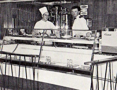
The two pictures below are from a MacBrayne's brochure of 1970:-


In winter in the 70s and 80s (when the Sacred Isle Cruise didn't run and Coll & Tiree and Colonsay were looked after by the Mull and Barra-'Boisdale ferries respectively) the Columba continued as the relief car ferry and was laid up at Greenock when not required where she is seen below in dry-dock in another superb picture by hebrides


That picture shows the vehicle loading hoist (down at car deck level) very clearly and also another less well known feature of the Columba and her sisters. Note the two vertical sliding doors, one up (left) and the other down (right). If you think they look a bit over-engineered just to seal the car deck while at sea, you'd be right. Commissioned at the height of the Cold War, these three car ferries were designed to be floating "citadels" (command posts) in the event of a "NBC (nuclear, biological or chemical) attack" and these doors were part of the equipment designed to hermetically seal the ship's accommodation. They were also equipped with apparatus to spray the decks to wash off nuclear fall-out etc.  
   
Cold War considerations aside, MacBraynes' priority in the 1960s and early 70s had been the introduction of car ferry services to the Western Isles even if, to begin with, this meant adopting less than ideal hoist-loading. In the 1980s the priority became to convert all the services to ro-ro.

In 1988, Calmac decided to axe the Sacred Isle Cruise and commission a new ro-ro ferry - the Lord of the Isles - which was also equipped with a hoist to cover the transition to serve Lochboisdale (ro-ro since 1974), Castlebay (converted to ro-ro 1989) and Coll & Tiree (converted to ro-ro early 90s). As the last remaining purely hoist-loading ferry in the fleet, the Columba was redundant and sold.

A vignette from an early 70s MacBrayne's brochure

But instead of going to the Aegean or the Red Sea pilgrim trade where most redundant British ferries go, the Columba was sold to a new venture started by a Yorkshire family who had previously operated canal boats: keen amarteur sailors in the Western Isles, they were storm-bound one day in Loch Scresort on the Isle of Rum, when they had the idea of offering exclusive "yacht-style" cruises on the west coast ...

... and as once again this post is getting overly long, this is a good point to break before the next instalment to come.