
Last year, I wrote a post (here) about what I call ghost junctions - major road junctions that have moved due to realignment of the roads concerned but where the original junction - the ghost - remains, either as a local junction between minor roads or just a faintly discernable footprint. For some reason, I forgot to mention in that post a particularly fine ghost junction - the one at Invergarry between the A82 and the A87 to Kyle of Lochalsh and Uig on Skye. But this, the second post in the series on the A87 (map in the first post), is the perfect place to remedy that omission.
Note first that, with all pictures in this and subsequent posts like the one below with a Google Streetview link under it, if you click the link it will take you to the position in GSV so you can have a virtual look round.
 |
| Invergarry A82/A87 junction - Google Streetview |
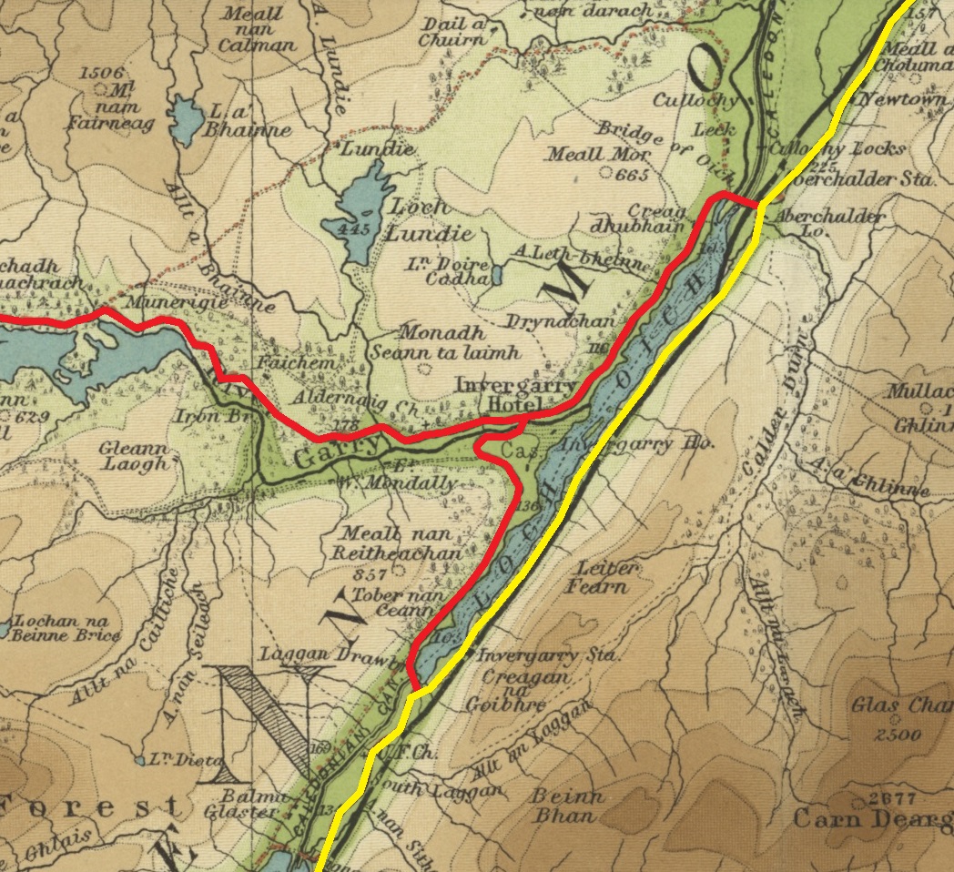
Pictured above is the present day junction viewed from the south and the bridge over the River Garry with the A87 going off to the left. But this only dates back to 1932 and before that the junction was at an older bridge 600 yards downstream (to the right/east). On the map below (click it to enlarge), the red line is the original approach from the south to the old bridge and junction and the blue line the current:-
 |
| Ordnance Survey 25 inch map, 1899 |
The old road and bridge still exist and are driveable and, fortunately for armchair ghost junction enthusiasts, the Google Streetview car has been along them. Approaching from the south, the old road leaves the present road just before the new bridge here - yes, you can turn onto that track on the right there! Continuing east, you'll end up at the old bridge over the Garry and the old junction on its far side.
 |
| Old junction at Invergarry - Google Streetview |
The road building history around here is that the first of General Wade's military roads was the one up the Great Glen from Fort William to Inverness built in 1725-27. It passed along the opposite (east) side of Loch Oich but a more general criticism of the Wade roads towards the end of the 18th century was that
"having been laid out with other views than promoting commerce and industry, are generally in such directions, and so inconveniently steep, as to be nearly unfit for the purposes of civil life; and in those parts where they are tolerably accessible ... the use of them is very much circumscribed from the want of bridges over some of the principal rivers."
Thus was born in 1803 the Highland Roads & Bridges Commission (HRBC). Set up by an Act of Parliament and under the engineering superintendence of Thomas Telford (most famous for the Menai Suspension Bridge and author of the words just quoted), the HRBC provided half of the costs of approved road and bridge building schemes, the other half to be met by the local landowners.
One of the earliest Parliamentary Roads (as they became known) was one down the west side of Loch Oich, with a bridge across the River Garry and linking with the military road on the east side of the loch at each end, and then, branching off from this, a road west up Glen Garry, along the north bank of the river and all the way to the west coast at Kinloch Hourn. Thus was built the old bridge and junction at Invergarry in about 1805-06.
 |
| Military road (1725-27) in yellow, Parliamentary (Highland Roads & Bridges Commission) road (1805-06) in red. Bartholomew's half inch map 1902-06 via National Libraries of Scotland |
 |
| Invergarry Old Bridge (1805-06) viewed from downstream (the east) |
Part of the HRBC's work had been to upgrade the road network from one designed in the pre-industrial era for the movement of troops to one adapted to the needs of commerce during the onset of the industrial revolution. 120 years later, there was another imperative - to adapt the road network to the needs of motor traffic. Hence in the 1920s, there began two major road improvement schemes in the Highlands, the A9 from Perth to Inverness in 1924-28 and the A82 from Tyndrum to Inverness via the Glen Coe and the Great Glen in 1931-33 (contemporary news article about that here). The latter scheme included the construction of a new concrete bridge at Invergarry and the re-arrangement of the A82/A87 junction in 1932.
 |
| The present bridge (1932) and A82/A87 junction looking south |
 |
| Invergarry - Google Streetview |
Note that the 1930s fingerpost at the top of this post indicates 52 3/4 miles to Kyle. So for all the diversons and re-routing the A87 has undergone over the years, it seems to be only 2 3/4 miles shorter between here and Kyle. You find the first such diversion only 200 yards beyond the far (west) end of Invergarry, less than a mile from the junction, at a sign pointing right to Faichem:-
 |
| Faichem junction - Google Streetview |
400 yards on from where the Faichem loop rejoins the main road, another stretch of the old road opens on the left (here). It's not a loop but remains as an access to Loch Garry Dam. The GSV car has been part of the way along. As there's a timber yard and sawmill down here as well, the traffic along this stretch of old road is heavier than on the Faichem loop so it gives a better idea of how this bit of the A87 may have looked when it was till a single track road in the early 1960s.
 | |
| The Ordnance Survey One Inch Map, 7th ed. drawn before this part of the A87 was doubled. The current line of the road is in orange leaving the Faichem loop (A to B) and the branch of the old road to Loch Garry Dam and timber yard (C to D). | |
 |
| Beside Loch Garry - Google Streetview |
Below is approximately the same spot in the 1930s:-

 |
| Kinlochourn junction - Google Streetview |
