.jpg)
Little Garve Bridge is something of a hidden treasure. Considering you can drive to (though not across) it and it's less than half a mile from a trunk road, I'm surprised it's not better known. I think it deserves one of these brown tourist attraction signs off the trunk road concerned - the A835 to Ullapool, just past Garve and the junction with the A832 west to Kyle of Lochalsh and Gairloch.


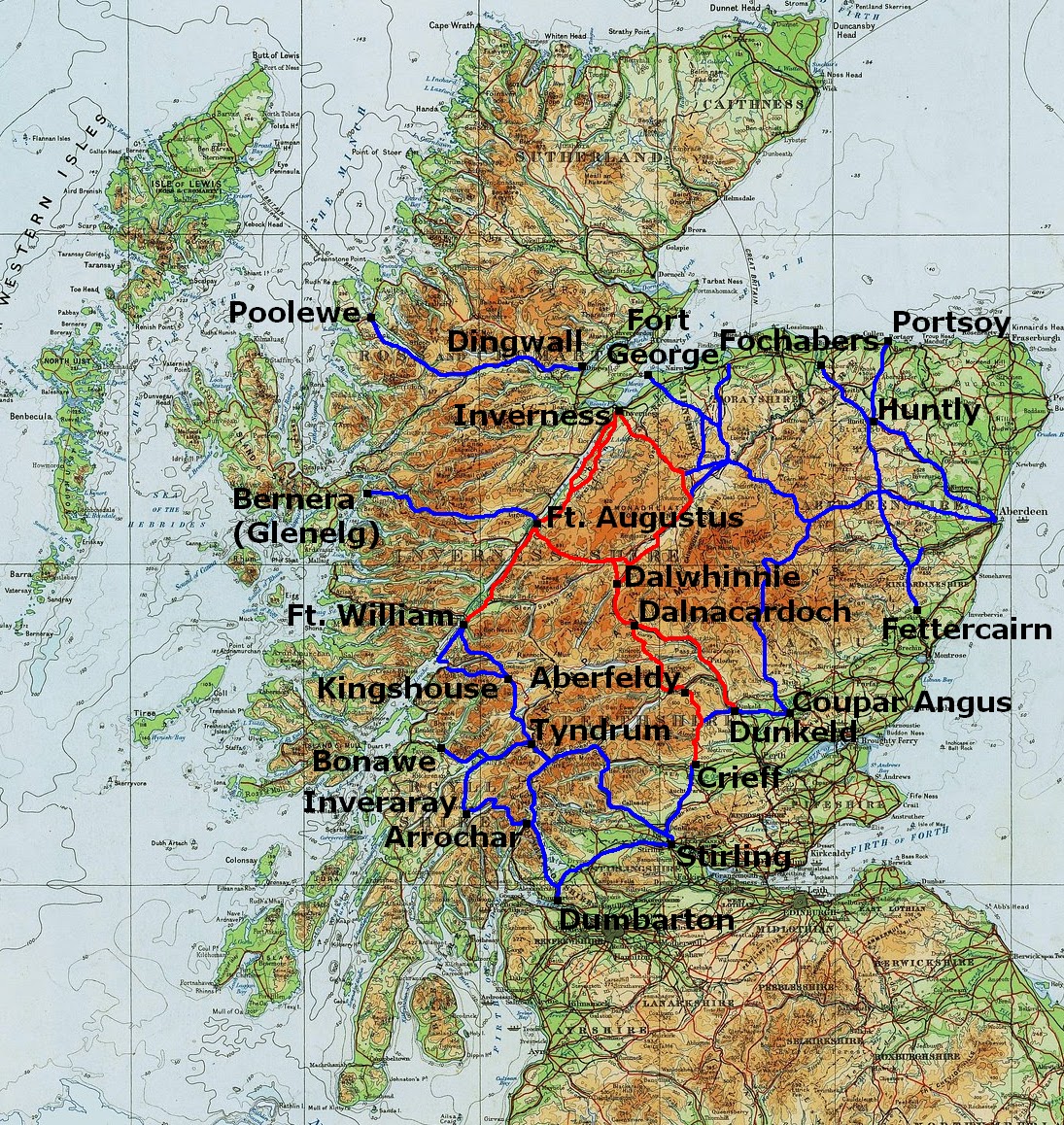 |
| Note that in this map I've mistakenly shown the road to Poolewe as beginning at Dingwall whereas I believe that, in fact, it began at Contin, about 6 miles west of Dingwall |
The Wade Roads were built in the 1720s and 1730s. They were a response to the Jacobite Rebellions of 1715 and 1719 when the main theatre of war had been the Highlands but where there were simply no roads (or bridges) along which the army could be deployed to counter the Highland clans which formed the back-bone of the rebel forces. It's often said the principal beneficiary of Wade's roads were, in fact, the Jacobites who used them to move their army around the Highlands during the final rebellion of 1745-46 (Bonnie Prince Charlie, Battle of Culloden). But that didn't deter further military road building under Caulfeild in the 1740s, 50s and 60s.

.jpg)
William Taylor in "The Military Roads in Scotland" goes so far as to say "Perhaps the only simple and certain fact about the [Contin-Poolewe] road is that, if it was ever made, it was not built by General Wade". The only other notice I've ever found of it is in "New Ways Through the Glens" by A R B Haldane: he records that the Countess of Seaforth, when travelling in 1799 between (presumably) her home at Brahan Castle (just east of Contin) and Poolewe for the packet (boat) to her husband's estates on Lewis, "could only get as far Loch Achanalt, fifteen miles from Contin, where her coach became a complete wreck".
I think the reason why Little Garve Bridge survived while the rest of the road decayed - although, once again, this is just educated guesswork - is that it was incorporated into a new road built in the mid 1790s at the behest of the British Fisheries Society to their new fishing village of Ullapool established in 1788. But this would only have reprieved the bridge for about 20 years because, when the Highland Roads and Bridges Commission (established in 1803) built its new road from Dingwall to Kyle of Lochalsh ("Kyle-Haken" as it was known then) in the 1810s, it bridged the River Blackwater 6 miles downstream from Little Garve at Contin and went along the south side of the Blackwater and Loch Garve, the route of the present day A835. Presumably, the military road on the north side (blue on the map below) was thereupon abandoned.
.jpg)
It's worth noting that the original Ullapool road, built in the 1790s, went straight across the hills as shown roughly in red on the map above instead of following the Blackwater as today's A835 does. I'll conclude this post with a description of the old road in George & Peter Anderson's "Guide to the Highlands and Islands of Scotland, including Orkney and Zetland" published in 1842:-
The district road to Loch Broom, and the village of Ullapool on the shores of that loch, strikes off near Garve Inn, proceeding over the high ascent of the Dirie More. Its course may be seen for a mile or so, tending to the north-east of Loch Garve; and then it bends suddenly westward over a very long and bleak ascent, instead of keeping due north, along the Dirie Water [i.e. the River Blackwater] by Achnaclerach and the deer forest of Kirkan, through which it is now proposed to carry an amended line. The distance to Ullapool is about thirty-seven miles. This road was made about fifty years ago, at the expense of government, and cost about £4500, and it was then one of the best roads in the Highlands; but it has for many years been neglected, and is sadly broken down in innumerable places, so as to be passable only to foot passengers and horsemen It conducts across a dreary district called Strath Dirie and the Dirie More, (the long road or step) to the glen at the head of the larger Loch Broom. There are two very indifferent public-houses on the way, the first at Glascarnock, about twelve miles from Strathgarve, and the other at Braemore, a like distance from the former, at which also provisions are not always to be had; ... The mountain torrents which cross the Ullapool road are exceedingly annoying to travellers; and the largest one; the Torran-du river, a little beyond Glascarnock, is not always fordable with safety; but we are glad to hear that this shocking road will not be permitted to remain long in its present condition to disgrace the county of Ross and that the district trustees have at length fairly commenced building bridges, and improving the worst parts. ... At present no vehicle can pass it, and the only expeditious mode of travelling is by riding a country pony or garron.
 |
| Fording the Torran-du (Abhainn an Torrain Duibh) in the 21st century |

Hi Neil, Another gem of an article. I went straight to Google maps to look for the old road - and I think I can follow it almost all the way over to Aultguish. Magic!
ReplyDelete