 |
| Picture credit Robert Orr |
The picture above came up in my Flickr contacts feed captioned as a ship going up the Clyde with wind turbine blades to King George V Dock.
In my ignorance, I was surprised to learn the KGV dock was still in operation considering the general rundown of shipping on the Upper Clyde. But Google Earth imagery (dating as recently as August 2016) showed a few ships in and a lot of turbine blades lying around.

A quick Google search brought me the picture below:-
 |
| KGV Dock looking east: Picture credit The Glasgow Story |
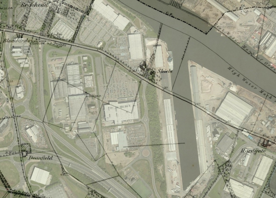
Note how the dock slices through Renfrew Road running from Govan to Renfrew leaving Shiels Farm visible just this side of the dock at the end of a cul-de-sac. The house in the foreground is Braehead House and all that's now covered by Braehead Shopping Centre etc. In fact Shiels Farmhouse is still standing in amongst the retail park, just east of the Sainsbury's petrol station:-
 |
| Shiels - looks to have been quite posh for a farmhouse: Picture credit Thomas Nugent via Geograph |
This is calling out to be viewed then and now on the National Libraries of Scotland Georeferenced Map Viewer (use the transparency of overlay slider):-
 |
| OS 6 inch map 1857 |
On the 1 inch map below, note how at the date of survey the road diversion must have been built but not yet the dock itself:-

And I enjoyed this picture taken in 1977 before the shopping centre etc. was built of a stretch of the Old Govan Road, now the cul-de-sac to Shiels west of the KGV Dock, with the tramlines still in it:-
 |
| Old Govan Road looking west: Picture credit David Douglas via Geograph |
This isn't the only point at which the road along the south side of the Clyde from Glasgow to Govan and Renfrew had to be diverted to accommodate new docks. It also had to be moved to loop round Prince's Dock built in the 1890s. (An earlier scheme involved Govan Road continuing on its original line and being carried across the entrance to the dock by a swing bridge. But this was later abandoned, not uncontroversially, as you can read here.):-
 |
| 1859 6 inch map superimposed over 1920s 1 inch map when the Prince's Dock still existed |
Back at the KGV Dock, it was built in 1931 to accommodate the increasingly larger ships that were getting too big for the Prince's and Queen's Docks further upriver so it was the last major development of Glasgow Harbour. It was originally intended that there be two more similar docks to the west but the economic downturn of the 1930s stopped them going ahead: you can see their outlines on the plan below of land belonging to the Clyde Navigation Trust (click to enlarge):-
 |
| Picture credit Ballast Trust |
There are lots of fascinating aerial pictures, old and new, on the KGV Dock's Canmore entry. The one below is my favourite:-
 |
| KGV Dock looking north east: Picture credit Canmore |
This led me into a bit of a digression about the history of Glasgow Harbour generally. My bible on this is Glasgow's River by Osborne, Quinn & Robertson which I've not looked at for a while. It's out of print now but you can get it second hand off Amazon - see here and 6,95€ including postage is well worth it.

Anyway, a thumbnail sketch of the history is that, in the 17th century, the Clyde was too shallow for seagoing ships to get up to Glasgow so, in 1662, with the city's international trade developing, the magistrates bought 13 acres of land downstream at Newark and built Port Glasgow. The following century, efforts were directed to deepening the river up to Glasgow by building groynes (dikes) out from the banks to narrow the flow of water but speed it up so that the river would scour itself deeper. This began in 1775 and in 1806 work began on joining the ends of the groynes with walls so as to canalise the river. Between the scouring effect and a lot of dredging, foreign going ships were able to reach the Broomielaw by 1818.
 |
| Glasgow around 1780 with ships at the Broomielaw to the west of Jamaica Street Bridge: Picture credit The Glasgow Story |
These works were carried out under Acts of Parliament which were consolidated in 1858 to create the Clyde Navigation Trust charged with running and developing Glasgow Harbour. In 1966, this venerable institution, headquartered at 16 Robertson Street, was merged with Greenock Harbour Trust and the Clyde Lighthouses Trust (which built and maintained the Cumbrae, Cloch and Toward Lights) to form the Clyde Port Authority.
The CPA (which had acquired Ardrossan Harbour in 1968, I think), in turn, was privatised in a management buyout in 1992 to become Clydeport PLC. (Trust ports like the CPA were an interesting sub-set of the privatisations of the 1980s and 90s in that they were given power to privatise themselves if they wanted to unlike the big utilities which were privatised compulsorily.) During the passage of the privatisation legislation through the House of Lords in 1991, the Viscount of Oxfuird (a forklift truck sales executive during the day) gave a thumbnail sketch of the decline of the Clyde as a port which caught my eye:-
It is important to concentrate for one moment on the changing patterns of trade over the recent past. What has happened is entirely beyond the control of the [CPA]. Some 73 per cent. of Britain's trade is now with Europe. That trade has shifted across from the west to the east and south coasts of England. Scottish industry is now based mainly on financial services in the high-tech province which is concerned with high value and low volume and is serviced by air freight or containers. There has been the advent of North Sea oil. Some 12 million tonnes of crude oil trade from the Middle East has been lost to the Clyde.
Scotch whisky used to be made from maize and corn from the United States and Canada. Today, except for a few tonnes of maverick imports from France, it is made from home-grown barley. Britain was formerly a net importer of 30 million tonnes of grain and cereals per year. The European common agricultural policy has changed that. We are now essentially self-sufficient. If anything, we are a modest net exporter.
In 1970 the Clyde exported 1.6 million tonnes of general cargo, mainly to Australia, New Zealand and the Far East. Containerisation changed all that. The trade was lost. Nevertheless the Clyde managed to convert some of it into 750,000 tonnes of container traffic.
Anyway, the newly privatised Clydeport bought the Hunterston Ore Terminal from British Steel in 1993 and the following year sold the land at Braehead once earmarked for the extension of the KGV Dock to a joint venture between Marks & Spencer and Sainsburys for £11m for the shopping centre.
In 2003, Clydeport was taken over by the Peel Group which also owns, amongst other things, Liverpool Docks and Airport as well as something else I was surprised to discover is still operational: the Manchester Ship Canal.
 |
| Peel's red branding in evidence at the Renfrew Road entrance to the KGV Dock |
So changing patterns of trade have transformed the KGV Dock from having been the Clyde Navigation Trust's furthest down-river facility for its biggest ships to its successor's furthest up-river facility for its smaller ships. And though not as busy as in its heyday, it's good to see some ships (apart from the Waverley) still going up the Clyde. And it's pleasing to know that, despite all the changes, Clydeport is still headquartered at 16 Robertson Street.
 |
| The M/S Abis Breskens proceeds up the Clyde to KGV Dock. The crane in the background is at the old John Brown's site in Clydebank (see here) Picture credit Robert Orr |

No comments:
Post a Comment